
ADNAN TORLAK
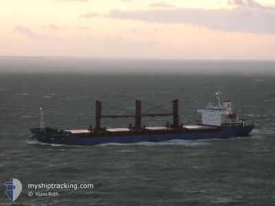
Bulk Carrier
Current Trip
| Trip Time | 14 days |
|---|---|
| Trip Distance | 2709.55 nm |
| AVG Speed | 9.3 Knots |
| MAX Speed | 14.5 Knots |
| Dybgang | 8.3 m |
| AVG Wind | 13.8 knots |
| MAX Wind | 34 knots |
| MIN Temp | 2.1°C / 35.78°F |
| MAX Temp | 18.4°C / 65.12°F |
| Position Modtaget | 22 m siden |
Current Position
| Longitude | -9.64122° |
|---|---|
| Latitude | 30.42512° |
| Status | Moored |
| Fart | |
| Kurs | 324° |
| Område | North Atlantic Ocean |
| Station | T-AIS |
| Position Modtaget | 22 m siden |
Info
Information
The current position of ADNAN TORLAK is in North Atlantic Ocean with coordinates 30.42512° / -9.64122° as reported on 2025-02-11 00:27 by AIS to our vessel tracker app. The vessel's current speed is 0 Knots and is currently inside the port of AGADIR.
The vessel ADNAN TORLAK (IMO: 9243253, MMSI: 636019529) is a Bulk Carrier that was built in 2001 ( 24 år gamle ). It's sailing under the flag of [LR] Liberia.
In this page you can find informations about the vessels current position, last detected port calls, and current voyage information. If the vessels is not in coverage by AIS you will find the latest position.
The current position of ADNAN TORLAK is detected by our AIS receivers and we are not responsible for the reliability of the data. The last position was recorded while the vessel was in Coverage by the Ais receivers of our vessel tracking app.
The current draught of ADNAN TORLAK as reported by AIS is 8.3 meters
Weather
| Temperature | 16°C / 60.8°F |
|---|---|
| Wind Speed | 3 knots |
| Direction | 62° ENE |
| Pressure | 1018.5 hPa |
| Humidity | 42.2 % |
| Cloud Coverage | --- |
Featured Company
Most Visited Ports (Last year)
| Port | Arrivals | |
|---|---|---|
| 2 | ||
| 2 | ||
| 2 | ||
| 1 | ||
| 1 | ||
| 1 |
Last Trips
| Origin | Departure | Destination | Arrival | Distance | |
|---|---|---|---|---|---|
| 2025-01-26 13:25 | 2025-02-10 09:07 | 2709.55 nm | |||
| 2025-01-05 17:23 | 2025-01-22 09:45 | 1067.80 nm | |||
| 2024-12-24 09:45 | 2025-01-05 11:15 | 802.28 nm | |||
| 2024-12-17 18:57 | 2024-12-21 21:02 | 786.55 nm | |||
| 2024-12-01 17:33 | 2024-12-14 02:32 | 2361.76 nm |
Events
| Tid | Hændelsen | Detaljer | Position / Dest | Info |
|---|---|---|---|---|
| 2025-02-11 00:39 | Status er ændret | Default Moored |
30.42514 / -9.64124
[MA] AGADIR
|
Fart: Kurs: 324° |
| 2025-02-11 00:27 | Status er ændret | Moored Default |
30.42512 / -9.64122
[MA] AGADIR
|
Fart: Kurs: 324° |
| 2025-02-11 00:27 | Indenfor Dækning |
30.42512 / -9.64122
North Atlantic Ocean
[MA] AGADIR
|
Fart: Kurs: 55° |
|
| 2025-02-10 08:27 | STOP Sejllads |
30.42507 / -9.64123
[MA] AGADIR
|
Fart: Kurs: 323° |
|
| 2025-02-10 08:07 | Skibe i havn |
|
30.42255 / -9.64201
[MA] AGADIR
|
Fart: 5.3 kn Kurs: 74° |
| 2025-02-10 06:28 | START Sejllads | 3.65 nm, West of AGADIR |
30.43394 / -9.70185
MA AGA
|
Fart: 6.5 kn Kurs: 155° |
| 2025-02-07 03:45 | Status er ændret | Default At anchor |
30.44397 / -9.70457
MA AGA
|
Fart: 0.2 kn Kurs: 144° |
| 2025-02-07 03:42 | Status er ændret | At anchor Default |
30.44401 / -9.70454
MA AGA
|
Fart: 0.2 kn Kurs: 133° |
| 2025-02-07 03:42 | Indenfor Dækning |
30.44401 / -9.70454
North Atlantic Ocean
MA AGA
|
Fart: 0.2 kn Kurs: 300.7° |
|
| 2025-02-07 03:42 | Udenfor Dækning |
30.44401 / -9.70454
North Atlantic Ocean
MA AGA
|
Fart: 0.2 kn Kurs: 300.7° |