
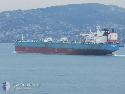
ADVANTAGE SPRING
Crude Oil Tanker
Current Trip
| Time Travelled | 1 day |
|---|---|
| Remaining Time | --- |
| Distance Travelled | 632.61 nm |
| Remaining Distance | --- |
| AVG Speed | 14.3 Knots |
| MAX Speed | 15.3 Knots |
| AVG Wind | 7.7 knots |
| MAX Wind | 17 knots |
| MIN Temp | 5.2°C / 41.36°F |
| MAX Temp | 13.2°C / 55.76°F |
| Dybgang | 9.2 m |
| Position Modtaget | Nu |
Current Position
| Longitude | 20.35626° |
|---|---|
| Latitude | 37.48586° |
| Status | Under way using engine |
| Fart | 14.5 Knots |
| Kurs | 134.3° |
| Område | Ionian Sea |
| Station | T-AIS |
| Position Modtaget | Nu |
Info
Information
The current position of ADVANTAGE SPRING is in Ionian Sea with coordinates 37.48586° / 20.35626° as reported on 2025-02-07 13:54 by AIS to our vessel tracker app. The vessel's current speed is 14.5 Knots and is heading at the port of KALI LIMENES. The estimated time of arrival as calculated by MyShipTracking vessel tracking app is 2025-02-08 12:00 LT
The vessel ADVANTAGE SPRING (IMO: 9466582, MMSI: 538006308) is a Crude Oil Tanker that was built in 2010 ( 15 år gamle ). It's sailing under the flag of [MH] Marshall Is.
In this page you can find informations about the vessels current position, last detected port calls, and current voyage information. If the vessels is not in coverage by AIS you will find the latest position.
The current position of ADVANTAGE SPRING is detected by our AIS receivers and we are not responsible for the reliability of the data. The last position was recorded while the vessel was in Coverage by the Ais receivers of our vessel tracking app.
The current draught of ADVANTAGE SPRING as reported by AIS is 9.2 meters
Weather
| Temperature | 11.9°C / 53.42°F |
|---|---|
| Wind Speed | 8 knots |
| Direction | 131° SE |
| Pressure | 1029.9 hPa |
| Humidity | 75 % |
| Cloud Coverage | 100 % |
Featured Company
Most Visited Ports (Last year)
| Port | Arrivals | |
|---|---|---|
| 3 | ||
| 1 | ||
| 1 | ||
| 1 | ||
| 1 | ||
| 1 |
Last Trips
| Origin | Departure | Destination | Arrival | Distance | |
|---|---|---|---|---|---|
| 2024-12-28 01:10 | 2025-02-04 06:51 | 2620.78 nm | |||
| 2024-11-16 07:44 | 2024-12-26 16:52 | 9514.38 nm |
Events
| Tid | Hændelsen | Detaljer | Position / Dest | Info |
|---|---|---|---|---|
| 2025-02-07 10:25 | Ændre havområde | Greek part of the Ionian Sea Italian part of the Adriatic Sea |
38.10062 / 19.68754
Ionian Sea
GRKLL
|
Fart: 14 kn Kurs: 168° |
| 2025-02-07 10:25 | Indenfor Dækning |
38.10062 / 19.68754
Ionian Sea
GRKLL
|
Fart: 14 kn Kurs: 168° |
|
| 2025-02-06 14:53 | Udenfor Dækning |
41.85476 / 16.66555
Adriatic Sea
GRKLL
|
Fart: 15 kn Kurs: 133.6° |
|
| 2025-02-06 12:37 | Ændre havområde | Italian part of the Adriatic Sea Croatian part of the Adriatic Sea |
42.22093 / 16.10530
Adriatic Sea
GRKLL
|
Fart: 14.5 kn Kurs: 142.3° |
| 2025-02-06 12:03 | ETA er ændret | 2025/02/08 10:00 2025/02/08 12:00 |
42.33267 / 15.98803
GRKLL
|
Fart: 14.7 kn Kurs: 142.1° |
| 2025-02-06 12:01 | Ændre havområde | Croatian part of the Adriatic Sea Italian part of the Adriatic Sea |
42.33652 / 15.98395
Adriatic Sea
GRKLL
|
Fart: 14.7 kn Kurs: 142.1° |
| 2025-02-06 11:22 | Ændre havområde | Italian part of the Adriatic Sea Croatian part of the Adriatic Sea |
42.46382 / 15.85055
Adriatic Sea
GRKLL
|
Fart: 14.7 kn Kurs: 141.8° |
| 2025-02-06 10:04 | Status er ændret | Under way using engine Default |
42.71131 / 15.57499
GRKLL
|
Fart: 14.6 kn Kurs: 138° |
| 2025-02-06 10:04 | Indenfor Dækning |
42.71131 / 15.57499
Adriatic Sea
GRKLL
|
Fart: 14.6 kn Kurs: 141.4° |
|
| 2025-02-05 23:51 | Udenfor Dækning |
44.66929 / 13.51076
Adriatic Sea
GRKLL
|
Fart: 14.4 kn Kurs: 147.7° |