

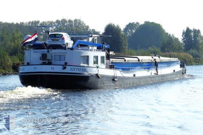
ANTIO SAS
Cargo

Current Trip
WEERT
| Time Travelled | 9 h, 51 mins |
|---|---|
| Remaining Time | --- |
| Distance Travelled | 0.27 nm |
| Remaining Distance | --- |
| AVG Speed | --- |
| MAX Speed | --- |
| AVG Wind | 3.9 knots |
| MAX Wind | 4 knots |
| MIN Temp | 5°C / 41°F |
| MAX Temp | 7.2°C / 44.96°F |
| Dybgang | 0.1 m |
| Position Modtaget | 3 h, 18 m siden |
Current Position
| Longitude | 5.69291° |
|---|---|
| Latitude | 51.44644° |
| Status | Under way using engine |
| Fart | |
| Kurs | --- |
| Område | North Sea |
| Station | T-AIS |
| Position Modtaget | 3 h, 18 m siden |
Information
The current position of ANTIO SAS is in North Sea with coordinates 51.44644° / 5.69291° as reported on 2025-03-05 01:55 by AIS to our vessel tracker app. The vessel's current speed is 0 Knots
The vessel ANTIO SAS (MMSI: 244700276) is a Cargo It's sailing under the flag of [NL] Netherlands.
In this page you can find informations about the vessels current position, last detected port calls, and current voyage information. If the vessels is not in coverage by AIS you will find the latest position.
The current position of ANTIO SAS is detected by our AIS receivers and we are not responsible for the reliability of the data. The last position was recorded while the vessel was in Coverage by the Ais receivers of our vessel tracking app.
The current draught of ANTIO SAS as reported by AIS is 0.1 meters
Weather
| Temperature | 5.2°C / 41.36°F |
|---|---|
| Wind Speed | 3 knots |
| Direction | 278° W |
| Pressure | 1025.4 hPa |
| Humidity | 71.6 % |
| Cloud Coverage | --- |


Featured Company
Last Port Calls
| Port | Arrival | Departure | Time In Port |
|---|---|---|---|
| 2025-03-04 12:39 | 2025-03-04 19:23 | 6 h | |
| 2025-03-04 08:14 | 2025-03-04 08:42 | 28 m | |
| 2025-03-04 00:40 | 2025-03-04 04:22 | 3 h | |
| 2025-03-03 23:47 | 2025-03-04 00:20 | 32 m | |
| 2025-03-03 20:00 | 2025-03-03 20:23 | 22 m | |
| 2025-03-03 15:47 | 2025-03-03 16:19 | 32 m | |
| 2025-02-28 18:02 | 2025-02-28 18:40 | 37 m | |
| 2025-02-28 13:48 | 2025-02-28 14:00 | 12 m | |
| 2025-02-25 19:11 | 2025-02-28 09:39 | 2 d | |
| 2025-02-25 07:22 | 2025-02-25 18:34 | 11 h |
Last Trips
| Origin | Departure | Destination | Arrival | Distance | |
|---|---|---|---|---|---|
| 2025-03-04 09:42 | 2025-03-04 13:39 | 18.40 nm | |||
| 2025-03-04 05:22 | 2025-03-04 09:14 | 30.06 nm | |||
| 2025-03-04 01:20 | 2025-03-04 01:40 | 2.62 nm | |||
| 2025-03-03 21:23 | 2025-03-04 00:47 | 29.99 nm | |||
| 2025-03-03 17:19 | 2025-03-03 21:00 | 17.87 nm | |||
| 2025-02-28 19:40 | 2025-03-03 16:47 | 39.01 nm | |||
| 2025-02-28 15:00 | 2025-02-28 19:02 | 18.28 nm | |||
| 2025-02-28 10:39 | 2025-02-28 14:48 | 31.14 nm | |||
| 2025-02-25 19:34 | 2025-02-25 20:11 | 4.30 nm | |||
| 2025-02-25 05:20 | 2025-02-25 08:22 | 22.95 nm |
Events
| Tid | Hændelsen | Detaljer | Position / Dest | Info |
|---|---|---|---|---|
| 2025-03-05 01:55 | Udenfor Dækning |
51.44644 / 5.69291
North Sea
WEERT
|
Fart: Kurs: 0° |
|
| 2025-03-05 01:54 | Indenfor Dækning |
51.44644 / 5.69291
North Sea
WEERT
|
Fart: Kurs: 0° |
|
| 2025-03-04 19:25 | Udenfor Dækning |
51.44442 / 5.69223
North Sea
WEERT
|
Fart: 4.5 kn Kurs: 6.1° |
|
| 2025-03-04 19:23 | Indenfor Dækning |
51.44222 / 5.69170
North Sea
WEERT
|
Fart: 1.6 kn Kurs: 273.1° |
|
| 2025-03-04 19:23 | Afsejlet fra sidste havn |
|
51.44220 / 5.69184
WEERT
|
Fart: 5.1 kn Kurs: 154.2° |
| 2025-03-04 12:46 | Udenfor Dækning |
51.70499 / 5.35424
North Sea
[NL] S-HERTOGENBOSCH
|
Fart: 5.1 kn Kurs: 154.2° |
|
| 2025-03-04 12:39 | Skibe i havn |
|
51.71499 / 5.34612
[NL] S-HERTOGENBOSCH
|
Fart: 6.1 kn Kurs: 153.5° |
| 2025-03-04 12:34 | Indenfor Dækning |
51.72283 / 5.34069
North Sea
WEERT
|
Fart: 5.4 kn Kurs: 168.5° |
|
| 2025-03-04 10:20 | Udenfor Dækning |
51.88511 / 5.44513
North Sea
WEERT
|
Fart: 10.2 kn Kurs: 234.8° |
|
| 2025-03-04 10:14 | START Sejllads | 0.77 nm, North East of TIEL |
51.89600 / 5.45781
WEERT
|
Fart: 7.8 kn Kurs: 161.3° |