
BERNHARD SCHULTE
Container Ship
Current Trip
| Time Travelled | 8 days |
|---|---|
| Remaining Time | 2 days |
| Distance Travelled | 3214.12 nm |
| Remaining Distance | 901.10 nm |
| AVG Speed | 14.3 Knots |
| MAX Speed | 20.9 Knots |
| AVG Wind | 13.7 knots |
| MAX Wind | 28.9 knots |
| MIN Temp | 3.8°C / 38.84°F |
| MAX Temp | 17°C / 62.6°F |
| Dybgang | 11.6 m |
| Position Modtaget | 1 d siden |
Current Position
| Longitude | -23.94778° |
|---|---|
| Latitude | 38.06858° |
| Status | Under way using engine |
| Fart | 12 Knots |
| Kurs | 96° |
| Område | North Atlantic Ocean |
| Station | T-AIS |
| Position Modtaget | 1 d siden |
Info
Information
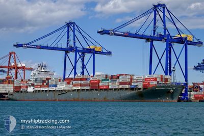
The current position of BERNHARD SCHULTE is in North Atlantic Ocean with coordinates 38.06858° / -23.94778° as reported on 2025-02-27 20:21 by AIS to our vessel tracker app. The vessel's current speed is 12 Knots and is heading at the port of ALGECIRAS. The estimated time of arrival as calculated by MyShipTracking vessel tracking app is 2025-03-03 02:36 LT
The vessel BERNHARD SCHULTE (IMO: 9484546, MMSI: 477639300) is a Container Ship that was built in 2010 ( 15 år gamle ). It's sailing under the flag of [HK] Hong Kong.
In this page you can find informations about the vessels current position, last detected port calls, and current voyage information. If the vessels is not in coverage by AIS you will find the latest position.
The current position of BERNHARD SCHULTE is detected by our AIS receivers and we are not responsible for the reliability of the data. The last position was recorded while the vessel was in Coverage by the Ais receivers of our vessel tracking app.
The current draught of BERNHARD SCHULTE as reported by AIS is 11.6 meters
Weather
| Temperature | 15°C / 59°F |
|---|---|
| Wind Speed | 22 knots |
| Direction | 358° N |
| Pressure | 1020.3 hPa |
| Humidity | 72.2 % |
| Cloud Coverage | 100 % |
Featured Company
Last Port Calls
| Port | Arrival | Departure | Time In Port |
|---|---|---|---|
| 2025-02-19 02:54 | 2025-02-20 07:34 | 1 d | |
| 2025-02-12 20:12 | 2025-02-13 09:17 | 13 h | |
| 2025-02-10 09:25 | 2025-02-11 13:41 | 1 d | |
| 2025-01-31 02:25 | 2025-01-31 11:12 | 8 h | |
| 2025-01-27 15:30 | 2025-01-28 14:59 | 23 h | |
| 2025-01-22 07:13 | 2025-01-23 20:58 | 1 d | |
| 2025-01-14 22:17 | 2025-01-20 20:59 | 5 d | |
| 2025-01-14 21:38 | 2025-01-14 22:06 | 28 m | |
| 2025-01-14 04:53 | 2025-01-14 18:17 | 13 h | |
| 2025-01-12 18:11 | 2025-01-13 07:06 | 12 h |
Last Trips
| Origin | Departure | Destination | Arrival | Distance | |
|---|---|---|---|---|---|
| 2025-02-13 04:17 | 2025-02-18 21:54 | 521.95 nm | |||
| 2025-02-11 08:41 | 2025-02-12 15:12 | 297.02 nm | |||
| 2025-01-31 12:12 | 2025-02-10 04:25 | 3319.39 nm | |||
| 2025-01-28 15:59 | 2025-01-31 03:25 | 901.24 nm | |||
| 2025-01-23 22:58 | 2025-01-27 16:30 | 1005.88 nm | |||
| 2025-01-20 23:59 | 2025-01-22 09:13 | 366.86 nm | |||
| 2025-01-15 01:06 | 2025-01-15 01:17 | 0.23 nm | |||
| 2025-01-14 21:17 | 2025-01-15 00:38 | 27.50 nm | |||
| 2025-01-13 10:06 | 2025-01-14 07:53 | 256.01 nm | |||
| 2025-01-11 07:33 | 2025-01-12 21:11 | 676.65 nm |
Events
| Tid | Hændelsen | Detaljer | Position / Dest | Info |
|---|---|---|---|---|
| 2025-02-27 20:31 | Status er ændret | Default Under way using engine |
38.06596 / -23.90468
ESALG
|
Fart: 12 kn Kurs: 96° |
| 2025-02-27 20:21 | Udenfor Dækning |
38.06858 / -23.94778
North Atlantic Ocean
ESALG
|
Fart: 12 kn Kurs: 96° |
|
| 2025-02-27 11:40 | Status er ændret | Under way using engine Default |
38.11118 / -26.03202
ESALG
|
Fart: 11 kn Kurs: 79° |
| 2025-02-27 11:20 | Status er ændret | Default Under way using engine |
38.09880 / -26.10437
ESALG
|
Fart: 10.6 kn Kurs: 75.5° |
| 2025-02-27 10:57 | Status er ændret | Under way using engine Default |
38.08375 / -26.19168
ESALG
|
Fart: 10.9 kn Kurs: 74° |
| 2025-02-27 10:44 | Indenfor Dækning |
38.08454 / -26.18732
North Atlantic Ocean
ESALG
|
Fart: 10.9 kn Kurs: 77.4° |
|
| 2025-02-27 09:39 | Status er ændret | Default Under way using engine |
38.02830 / -26.48865
ESALG
|
Fart: 11.1 kn Kurs: 82.4° |
| 2025-02-27 09:37 | Status er ændret | Under way using engine Default |
38.02726 / -26.49838
ESALG
|
Fart: 10.9 kn Kurs: 82° |
| 2025-02-27 09:37 | Indenfor Dækning |
38.02726 / -26.49838
North Atlantic Ocean
ESALG
|
Fart: 11.1 kn Kurs: 82.4° |
|
| 2025-02-27 09:37 | Udenfor Dækning |
38.02726 / -26.49838
North Atlantic Ocean
ESALG
|
Fart: 11.1 kn Kurs: 82.4° |