
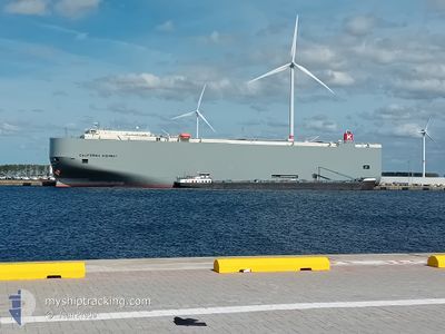
CALIFORNIA HIGHWAY
Vehicles Carrier
Current Trip
| Time Travelled | 6 days |
|---|---|
| Remaining Time | 1 day |
| Distance Travelled | 2750.32 nm |
| Remaining Distance | 589.53 nm |
| AVG Speed | 17.6 Knots |
| MAX Speed | 19 Knots |
| AVG Wind | 8.5 knots |
| MAX Wind | 17 knots |
| MIN Temp | 22.9°C / 73.22°F |
| MAX Temp | 28.3°C / 82.94°F |
| Dybgang | 9.7 m |
| Position Modtaget | 2 d siden |
Current Position
| Longitude | 76.96774° |
|---|---|
| Latitude | 7.98469° |
| Status | Under way using engine |
| Fart | 17.2 Knots |
| Kurs | 300.8° |
| Område | Laccadive Sea |
| Station | T-AIS |
| Position Modtaget | 2 d siden |
Info
Information
The current position of CALIFORNIA HIGHWAY is in Laccadive Sea with coordinates 7.98469° / 76.96774° as reported on 2026-01-01 21:22 by AIS to our vessel tracker app. The vessel's current speed is 17.2 Knots and is heading at the port of SOHAR. The estimated time of arrival as calculated by MyShipTracking vessel tracking app is 2026-01-05 15:46 LT
The vessel CALIFORNIA HIGHWAY (IMO: 9574078, MMSI: 352732000) is a Vehicles Carrier that was built in 2010 ( 16 år gamle ). It's sailing under the flag of [PA] Panama.
In this page you can find informations about the vessels current position, last detected port calls, and current voyage information. If the vessels is not in coverage by AIS you will find the latest position.
The current position of CALIFORNIA HIGHWAY is detected by our AIS receivers and we are not responsible for the reliability of the data. The last position was recorded while the vessel was in Coverage by the Ais receivers of our vessel tracking app.
The current draught of CALIFORNIA HIGHWAY as reported by AIS is 9.7 meters
Weather
| Temperature | 23.1°C / 73.58°F |
|---|---|
| Wind Speed | 14 knots |
| Direction | 41° NE |
| Pressure | 1018.9 hPa |
| Humidity | 64.5 % |
| Cloud Coverage | --- |
Featured Company
Last Port Calls
| Port | Arrival | Departure | Time In Port |
|---|---|---|---|
| 2025-12-28 10:14 | 2025-12-29 02:16 | 16 h | |
| 2025-12-25 13:53 | 2025-12-26 03:43 | 13 h | |
| 2025-12-15 09:14 | 2025-12-15 21:10 | 11 h | |
| 2025-12-08 10:51 | 2025-12-09 17:18 | 1 d | |
| 2025-12-07 08:05 | 2025-12-07 16:04 | 7 h | |
| 2025-12-06 13:49 | 2025-12-06 19:09 | 5 h | |
| 2025-11-17 04:30 | 2025-11-19 01:34 | 1 d |
Last Trips
| Origin | Departure | Destination | Arrival | Distance | |
|---|---|---|---|---|---|
| 2025-12-26 03:43 | 2025-12-28 10:14 | 790.80 nm | |||
| 2025-12-15 21:10 | 2025-12-25 13:53 | 2778.32 nm | |||
| 2025-12-09 17:18 | 2025-12-15 09:14 | 1620.45 nm | |||
| 2025-12-07 16:04 | 2025-12-08 10:51 | 223.46 nm | |||
| 2025-12-06 19:09 | 2025-12-07 08:05 | 181.52 nm | |||
| 2025-11-19 01:34 | 2025-12-06 13:49 | 6967.40 nm | |||
| 2025-10-30 15:40 | 2025-11-17 04:30 | 7445.90 nm |
Events
| Tid | Hændelsen | Detaljer | Position / Dest | Info |
|---|---|---|---|---|
| 2026-01-01 21:29 | Status er ændret | Default Under way using engine |
7.99878 / 76.93906
OM SOH
|
Fart: 17.2 kn Kurs: 300.8° |
| 2026-01-01 21:22 | Udenfor Dækning |
7.98469 / 76.96774
Laccadive Sea
OM SOH
|
Fart: 17.2 kn Kurs: 300.8° |
|
| 2026-01-01 19:29 | ETA er ændret | 2026/01/05 12:30 2026/01/05 04:00 |
7.62515 / 77.36146
OM SOH
|
Fart: 16.9 kn Kurs: 309.8° |
| 2026-01-01 19:13 | Fundet i havområde | Indian part of the Laccadive Sea |
7.57682 / 77.41981
Laccadive Sea
OM SOH
|
Fart: 17.1 kn Kurs: 309.4° |
| 2026-01-01 19:13 | Status er ændret | Under way using engine Default |
7.57682 / 77.41981
OM SOH
|
Fart: 17.2 kn Kurs: 310° |
| 2026-01-01 18:54 | Indenfor Dækning |
7.57682 / 77.41981
Laccadive Sea
OM SOH
|
Fart: 17.1 kn Kurs: 309.4° |
|
| 2025-12-29 02:09 | Status er ændret | Default Under way using engine |
2.21633 / 101.98386
OM SOH
|
Fart: 18.3 kn Kurs: 308.7° |
| 2025-12-29 02:03 | Udenfor Dækning |
2.19896 / 102.00629
Malacca Strait
OM SOH
|
Fart: 18.3 kn Kurs: 308.7° |
|
| 2025-12-29 00:37 | Status er ændret | Under way using engine Default |
1.91870 / 102.35022
OM SOH
|
Fart: 18.6 kn Kurs: 296° |
| 2025-12-29 00:15 | Status er ændret | Default Under way using engine |
1.86893 / 102.45373
OM SOH
|
Fart: 18.5 kn Kurs: 295.4° |