
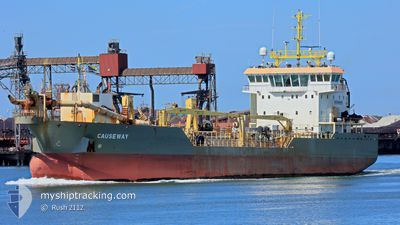
CAUSEWAY
Trailing Suction Hopper Dredger
Current Trip
COTONOU
| Time Travelled | 11 h, 44 mins |
|---|---|
| Remaining Time | --- |
| Distance Travelled | 46.58 nm |
| Remaining Distance | --- |
| AVG Speed | 9.1 Knots |
| MAX Speed | 10.9 Knots |
| AVG Wind | 10.3 knots |
| MAX Wind | 12 knots |
| MIN Temp | 27.1°C / 80.78°F |
| MAX Temp | 27.9°C / 82.22°F |
| Dybgang | 4 m |
| Position Modtaget | 2025-10-18 00:44 |
Current Position
| Longitude | -19.07842° |
|---|---|
| Latitude | 13.93121° |
| Status | Under way using engine |
| Fart | 10.7 Knots |
| Kurs | 166.6° |
| Område | North Atlantic Ocean |
| Station | T-AIS |
| Position Modtaget | 2025-10-18 00:44 |
Info
Information
The current position of CAUSEWAY is in North Atlantic Ocean with coordinates 13.93121° / -19.07842° as reported on 2025-10-18 00:44 by AIS to our vessel tracker app. The vessel's current speed is 10.7 Knots
The vessel CAUSEWAY (IMO: 9653197, MMSI: 210523000) is a Trailing Suction Hopper Dredger that was built in 2013 ( 13 år gamle ). It's sailing under the flag of [CY] Cyprus.
In this page you can find informations about the vessels current position, last detected port calls, and current voyage information. If the vessels is not in coverage by AIS you will find the latest position.
The current position of CAUSEWAY is detected by our AIS receivers and we are not responsible for the reliability of the data. The last position was recorded while the vessel was in Coverage by the Ais receivers of our vessel tracking app.
The current draught of CAUSEWAY as reported by AIS is 4 meters
Weather
| Temperature | 27.8°C / 82.04°F |
|---|---|
| Wind Speed | 11 knots |
| Direction | 185° S |
| Pressure | 1010.7 hPa |
| Humidity | 79.7 % |
| Cloud Coverage | 89 % |
Featured Company
Last Port Calls
| Port | Arrival | Departure | Time In Port |
|---|---|---|---|
| 2026-01-05 09:12 | 2026-01-07 08:01 | 1 d | |
| 2025-12-10 09:25 | 2025-12-14 14:45 | 4 d | |
| 2025-11-28 10:09 | 2025-11-30 03:57 | 1 d | |
| 2025-11-25 06:56 | 2025-11-25 08:16 | 1 h | |
| 2025-11-17 08:12 | 2025-11-18 13:20 | 1 d | |
| 2025-11-05 12:08 | 2025-11-06 15:52 | 1 d |
Most Visited Ports (Last year)
| Port | Arrivals | |
|---|---|---|
| 29 | ||
| 25 | ||
| 13 | ||
| 9 | ||
| 7 | ||
| 7 |
Last Trips
| Origin | Departure | Destination | Arrival | Distance | |
|---|---|---|---|---|---|
| 2025-12-14 14:45 | 2026-01-05 09:12 | 1072.14 nm | |||
| 2025-11-30 03:57 | 2025-12-10 09:25 | 773.10 nm | |||
| 2025-11-25 08:16 | 2025-11-28 10:09 | 277.21 nm | |||
| 2025-11-18 13:20 | 2025-11-25 06:56 | 563.39 nm | |||
| 2025-11-06 15:52 | 2025-11-17 08:12 | 907.85 nm | |||
| 2025-10-28 05:44 | 2025-11-05 12:08 | 701.35 nm |
Events
| Tid | Hændelsen | Detaljer | Position / Dest | Info |
|---|---|---|---|---|
| 2026-01-07 18:25 | START Sejllads | 11.85 nm, West of COTONOU |
6.33453 / 2.23284
COTONOU
|
Fart: 7.2 kn Kurs: 192° |
| 2026-01-07 17:45 | STOP Sejllads | 11.88 nm, West of COTONOU |
6.33688 / 2.23213
COTONOU
|
Fart: 0.1 kn Kurs: 22° |
| 2026-01-07 15:45 | START Sejllads | 12.03 nm, West of COTONOU |
6.33467 / 2.22976
COTONOU
|
Fart: 8.2 kn Kurs: 177° |
| 2026-01-07 15:09 | STOP Sejllads | 12.09 nm, West of COTONOU |
6.33753 / 2.22869
COTONOU
|
Fart: 0.2 kn Kurs: 357° |
| 2026-01-07 13:25 | START Sejllads | 12.08 nm, West of COTONOU |
6.33511 / 2.22893
COTONOU
|
Fart: 7.9 kn Kurs: 178° |
| 2026-01-07 12:49 | STOP Sejllads | 12.08 nm, West of COTONOU |
6.33744 / 2.22882
COTONOU
|
Fart: 0.1 kn Kurs: 349° |
| 2026-01-07 11:05 | START Sejllads | 12.05 nm, West of COTONOU |
6.33411 / 2.22948
COTONOU
|
Fart: 7.5 kn Kurs: 173° |
| 2026-01-07 10:05 | STOP Sejllads | 12.07 nm, West of COTONOU |
6.33633 / 2.22895
COTONOU
|
Fart: 0.2 kn Kurs: 344° |
| 2026-01-07 07:01 | START Sejllads | 0.78 nm, South East of COTONOU |
6.33788 / 2.44268
COTONOU
|
Fart: 10.3 kn Kurs: 173° |
| 2026-01-07 07:01 | Afsejlet fra sidste havn |
|
6.33788 / 2.44268
COTONOU
|
Fart: 1.7 kn Kurs: 101° |