
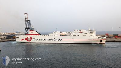
CIUDAD DE VALENCIA
Passenger
Current Trip
ESACE
| Time Travelled | 10 h, 7 mins |
|---|---|
| Remaining Time | --- |
| Distance Travelled | 194.93 nm |
| Remaining Distance | --- |
| AVG Speed | 20.1 Knots |
| MAX Speed | 20.7 Knots |
| AVG Wind | 2.9 knots |
| MAX Wind | 5 knots |
| MIN Temp | 16.2°C / 61.16°F |
| MAX Temp | 17.4°C / 63.32°F |
| Dybgang | 6.6 m |
| Position Modtaget | 14 h, 43 m siden |
Current Position
| Longitude | -13.81578° |
|---|---|
| Latitude | 28.51397° |
| Status | Under way using engine |
| Fart | 20.5 Knots |
| Kurs | 30.9° |
| Område | North Atlantic Ocean |
| Station | T-AIS |
| Position Modtaget | 14 h, 43 m siden |
Information
The current position of CIUDAD DE VALENCIA is in North Atlantic Ocean with coordinates 28.51397° / -13.81578° as reported on 2025-03-01 19:22 by AIS to our vessel tracker app. The vessel's current speed is 20.5 Knots
The vessel CIUDAD DE VALENCIA (IMO: 9869722, MMSI: 247432300) is a Passenger It's sailing under the flag of [IT] Italy.
In this page you can find informations about the vessels current position, last detected port calls, and current voyage information. If the vessels is not in coverage by AIS you will find the latest position.
The current position of CIUDAD DE VALENCIA is detected by our AIS receivers and we are not responsible for the reliability of the data. The last position was recorded while the vessel was in Coverage by the Ais receivers of our vessel tracking app.
The current draught of CIUDAD DE VALENCIA as reported by AIS is 6.6 meters
Weather
| Temperature | 16.2°C / 61.16°F |
|---|---|
| Wind Speed | 4 knots |
| Direction | 169° S |
| Pressure | 1013 hPa |
| Humidity | 72 % |
| Cloud Coverage | 9 % |
Featured Company
Last Port Calls
| Port | Arrival | Departure | Time In Port |
|---|---|---|---|
| 2025-03-01 21:11 | 2025-03-01 23:59 | 2 h | |
| 2025-03-01 17:40 | 2025-03-01 19:15 | 1 h | |
| 2025-03-01 08:07 | 2025-03-01 12:28 | 4 h | |
| 2025-02-28 21:30 | 2025-03-01 01:29 | 3 h | |
| 2025-02-27 20:57 | 2025-02-28 16:15 | 19 h | |
| 2025-02-27 08:59 | 2025-02-27 15:52 | 6 h | |
| 2025-02-27 03:20 | 2025-02-27 06:21 | 3 h | |
| 2025-02-26 19:15 | 2025-02-26 20:58 | 1 h | |
| 2025-02-24 07:25 | 2025-02-25 13:14 | 1 d | |
| 2025-02-22 21:27 | 2025-02-22 23:39 | 2 h |
Most Visited Ports (Last year)
| Port | Arrivals | |
|---|---|---|
| 105 | ||
| 104 | ||
| 104 | ||
| 60 | ||
| 53 | ||
| 52 |
Last Trips
| Origin | Departure | Destination | Arrival | Distance | |
|---|---|---|---|---|---|
| 2025-03-01 19:15 | 2025-03-01 21:11 | 32.84 nm | |||
| 2025-03-01 12:28 | 2025-03-01 17:40 | 102.94 nm | |||
| 2025-03-01 01:29 | 2025-03-01 08:07 | 53.52 nm | |||
| 2025-02-28 16:15 | 2025-02-28 21:30 | 103.53 nm | |||
| 2025-02-27 15:52 | 2025-02-27 20:57 | 105.40 nm | |||
| 2025-02-27 06:21 | 2025-02-27 08:59 | 53.13 nm | |||
| 2025-02-26 20:58 | 2025-02-27 03:20 | 103.08 nm | |||
| 2025-02-25 14:14 | 2025-02-26 19:15 | 619.43 nm | |||
| 2025-02-22 23:39 | 2025-02-24 08:25 | 589.07 nm | |||
| 2025-02-22 19:14 | 2025-02-22 21:27 | 32.31 nm |
Events
| Tid | Hændelsen | Detaljer | Position / Dest | Info |
|---|---|---|---|---|
| 2025-03-01 23:59 | Afsejlet fra sidste havn |
|
28.95271 / -13.52657
ESACE
|
Fart: 6.2 kn Kurs: 199° |
| 2025-03-01 23:52 | START Sejllads |
28.96536 / -13.52987
[ES] ARRECIFE
|
Fart: 6.5 kn Kurs: 205° |
|
| 2025-03-01 21:35 | STOP Sejllads |
28.97002 / -13.52701
[ES] ARRECIFE
|
Fart: Kurs: 194° |
|
| 2025-03-01 21:11 | Skibe i havn |
|
28.96057 / -13.53262
[ES] ARRECIFE
|
Fart: 7.5 kn Kurs: 23° |
| 2025-03-01 19:27 | Status er ændret | Default Under way using engine |
28.54022 / -13.79833
ESACE
|
Fart: 20.5 kn Kurs: 30.9° |
| 2025-03-01 19:22 | Udenfor Dækning |
28.51397 / -13.81578
North Atlantic Ocean
ESACE
|
Fart: 20.5 kn Kurs: 30.9° |
|
| 2025-03-01 19:15 | Afsejlet fra sidste havn |
|
28.48631 / -13.84216
ESACE
|
Fart: 13.2 kn Kurs: 57° |
| 2025-03-01 19:07 | START Sejllads |
28.49150 / -13.85635
[ES] PUERTO DEL ROSARIO
|
Fart: 6.2 kn Kurs: 181° |
|
| 2025-03-01 19:05 | Dybgangen er ændret | 6.6 6.5 |
28.49367 / -13.85595
[ES] PUERTO DEL ROSARIO
|
Fart: 1.4 kn Kurs: 175° |
| 2025-03-01 19:05 | Destination er ændret | ESACE ES |
28.49367 / -13.85595
[ES] PUERTO DEL ROSARIO
|
Fart: 1.4 kn Kurs: 175° |