
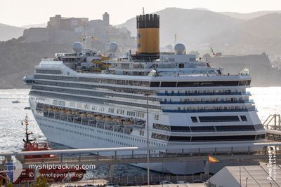
COSTA FORTUNA
Passengers Ship
Current Trip
BQKRA
| Time Travelled | 1 day |
|---|---|
| Remaining Time | --- |
| Distance Travelled | 494.70 nm |
| Remaining Distance | --- |
| AVG Speed | 12.9 Knots |
| MAX Speed | 18.3 Knots |
| AVG Wind | 13.7 knots |
| MAX Wind | 17 knots |
| MIN Temp | 24.4°C / 75.92°F |
| MAX Temp | 26.7°C / 80.06°F |
| Dybgang | 8.3 m |
| Position Modtaget | 4 m siden |
Current Position
| Longitude | -68.27794° |
|---|---|
| Latitude | 12.14920° |
| Status | Moored |
| Fart | 0.1 Knots |
| Kurs | 159° |
| Område | Caribbean Sea |
| Station | T-AIS |
| Position Modtaget | 4 m siden |
Info
Information
The current position of COSTA FORTUNA is in Caribbean Sea with coordinates 12.14920° / -68.27794° as reported on 2025-03-09 15:29 by AIS to our vessel tracker app. The vessel's current speed is 0.1 Knots
The vessel COSTA FORTUNA (IMO: 9239783, MMSI: 247094800) is a Passengers Ship that was built in 2003 ( 22 år gamle ). It's sailing under the flag of [IT] Italy.
In this page you can find informations about the vessels current position, last detected port calls, and current voyage information. If the vessels is not in coverage by AIS you will find the latest position.
The current position of COSTA FORTUNA is detected by our AIS receivers and we are not responsible for the reliability of the data. The last position was recorded while the vessel was in Coverage by the Ais receivers of our vessel tracking app.
The current draught of COSTA FORTUNA as reported by AIS is 8.3 meters
Weather
| Temperature | 26.2°C / 79.16°F |
|---|---|
| Wind Speed | 15 knots |
| Direction | 98° E |
| Pressure | 1016.7 hPa |
| Humidity | 76.6 % |
| Cloud Coverage | 30 % |
Featured Company
Last Port Calls
| Port | Arrival | Departure | Time In Port |
|---|---|---|---|
| 2025-03-07 07:03 | 2025-03-07 23:09 | 16 h | |
| 2025-03-06 06:52 | 2025-03-06 22:33 | 15 h | |
| 2025-03-05 06:20 | 2025-03-05 18:36 | 12 h | |
| 2025-03-03 07:08 | 2025-03-03 18:24 | 11 h | |
| 2025-03-02 07:19 | 2025-03-02 18:13 | 10 h | |
| 2025-02-28 06:41 | 2025-02-28 23:18 | 16 h | |
| 2025-02-27 06:50 | 2025-02-27 22:09 | 15 h | |
| 2025-02-26 07:31 | 2025-02-26 18:21 | 10 h | |
| 2025-02-25 06:59 | 2025-02-25 17:22 | 10 h | |
| 2025-02-24 06:58 | 2025-02-24 19:10 | 12 h |
Last Trips
| Origin | Departure | Destination | Arrival | Distance | |
|---|---|---|---|---|---|
| 2025-03-06 22:33 | 2025-03-07 07:03 | 123.79 nm | |||
| 2025-03-05 18:36 | 2025-03-06 06:52 | 137.89 nm | |||
| 2025-03-03 18:24 | 2025-03-05 06:20 | 266.57 nm | |||
| 2025-03-02 18:13 | 2025-03-03 07:08 | 131.43 nm | |||
| 2025-02-28 23:18 | 2025-03-02 07:19 | 376.03 nm | |||
| 2025-02-27 22:09 | 2025-02-28 06:41 | 123.38 nm | |||
| 2025-02-26 18:21 | 2025-02-27 06:50 | 196.40 nm | |||
| 2025-02-25 17:22 | 2025-02-26 07:31 | 135.59 nm | |||
| 2025-02-24 19:10 | 2025-02-25 06:59 | 132.13 nm | |||
| 2025-02-23 17:59 | 2025-02-24 06:58 | 133.68 nm |
Events
| Tid | Hændelsen | Detaljer | Position / Dest | Info |
|---|---|---|---|---|
| 2025-03-09 12:20 | Status er ændret | Moored Under way using engine |
12.14918 / -68.27796
BQKRA
|
Fart: 0.2 kn Kurs: 160° |
| 2025-03-09 12:12 | STOP Sejllads | 7.41 nm, South East of GOTO |
12.14968 / -68.27836
BQKRA
|
Fart: 0.3 kn Kurs: 150° |
| 2025-03-09 09:37 | Dybgangen er ændret | 8.3 8 |
12.05519 / -68.08911
BQKRA
|
Fart: 13.1 kn Kurs: 239° |
| 2025-03-09 09:37 | Destination er ændret | BQKRA GPPTP |
12.05519 / -68.08911
BQKRA
|
Fart: 13.1 kn Kurs: 239° |
| 2025-03-09 09:37 | ETA er ændret | 2025/03/09 12:00 |
12.05519 / -68.08911
BQKRA
|
Fart: 13.1 kn Kurs: 239° |
| 2025-03-09 09:30 | Status er ændret | Under way using engine Default |
12.06869 / -68.06558
GPPTP
|
Fart: 13.1 kn Kurs: 240° |
| 2025-03-09 09:23 | Status er ændret | Default Under way using engine |
12.08176 / -68.04333
GPPTP
|
Fart: 13.1 kn Kurs: 240° |
| 2025-03-09 09:13 | Ændre havområde | Bonaire part of the Caribbean Sea Guadeloupe and Martinique part of the Caribbean Sea |
12.09929 / -68.01302
Caribbean Sea
|
Fart: 13.1 kn Kurs: 240° |
| 2025-03-09 09:13 | Status er ændret | Under way using engine Default |
12.10020 / -68.01139
GPPTP
|
Fart: 13.4 kn Kurs: 240° |
| 2025-03-09 09:00 | Indenfor Dækning |
12.09929 / -68.01302
Caribbean Sea
|
Fart: 13.1 kn Kurs: 240° |