
ETE N
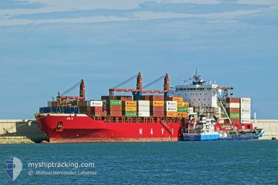
Container Ship
Current Trip
| Time Travelled | 12 h, 47 mins |
|---|---|
| Remaining Time | 2 days |
| Distance Travelled | 136.71 nm |
| Remaining Distance | 731.86 nm |
| AVG Speed | 11.6 Knots |
| MAX Speed | 12.6 Knots |
| AVG Wind | 9.5 knots |
| MAX Wind | 18.7 knots |
| MIN Temp | 10.6°C / 51.08°F |
| MAX Temp | 13.4°C / 56.12°F |
| Dybgang | 11 m |
| Position Modtaget | 2 h, 51 m siden |
Current Position
| Longitude | 6.81129° |
|---|---|
| Latitude | 42.98357° |
| Status | Under way using engine |
| Fart | 11.8 Knots |
| Kurs | 197.3° |
| Område | Mediterranean Sea - Western Basin |
| Station | T-AIS |
| Position Modtaget | 2 h, 51 m siden |
Info
Information
The current position of ETE N is in Mediterranean Sea - Western Basin with coordinates 42.98357° / 6.81129° as reported on 2025-02-28 18:17 by AIS to our vessel tracker app. The vessel's current speed is 11.8 Knots and is heading at the port of ALGECIRAS. The estimated time of arrival as calculated by MyShipTracking vessel tracking app is 2025-03-03 10:04 LT
The vessel ETE N (IMO: 9509126, MMSI: 636019197) is a Container Ship that was built in 2012 ( 13 år gamle ). It's sailing under the flag of [LR] Liberia.
In this page you can find informations about the vessels current position, last detected port calls, and current voyage information. If the vessels is not in coverage by AIS you will find the latest position.
The current position of ETE N is detected by our AIS receivers and we are not responsible for the reliability of the data. The last position was recorded while the vessel was in Coverage by the Ais receivers of our vessel tracking app.
The current draught of ETE N as reported by AIS is 11 meters
Weather
| Temperature | 11.6°C / 52.88°F |
|---|---|
| Wind Speed | 3 knots |
| Direction | 177° S |
| Pressure | 1017.4 hPa |
| Humidity | 68.7 % |
| Cloud Coverage | 100 % |
Featured Company
Last Port Calls
| Port | Arrival | Departure | Time In Port |
|---|---|---|---|
| 2025-02-27 12:40 | 2025-02-28 08:22 | 19 h | |
| 2025-02-24 03:11 | 2025-02-25 02:53 | 23 h | |
| 2025-02-21 07:33 | 2025-02-22 11:25 | 1 d | |
| 2025-02-18 02:08 | 2025-02-18 15:08 | 13 h | |
| 2025-02-16 08:39 | 2025-02-16 22:13 | 13 h | |
| 2025-02-12 15:47 | 2025-02-13 14:44 | 22 h | |
| 2025-02-09 19:04 | 2025-02-10 10:50 | 15 h | |
| 2025-02-07 09:24 | 2025-02-08 09:56 | 1 d | |
| 2025-02-04 21:26 | 2025-02-04 22:43 | 1 h | |
| 2025-02-04 10:25 | 2025-02-04 19:39 | 9 h |
Most Visited Ports (Last year)
| Port | Arrivals | |
|---|---|---|
| 18 | ||
| 17 | ||
| 13 | ||
| 11 | ||
| 11 | ||
| 4 |
Last Trips
| Origin | Departure | Destination | Arrival | Distance | |
|---|---|---|---|---|---|
| 2025-02-25 03:53 | 2025-02-27 13:40 | 266.42 nm | |||
| 2025-02-22 12:25 | 2025-02-24 04:11 | 379.33 nm | |||
| 2025-02-18 16:08 | 2025-02-21 08:33 | 496.89 nm | |||
| 2025-02-16 23:13 | 2025-02-18 03:08 | 92.37 nm | |||
| 2025-02-13 15:44 | 2025-02-16 09:39 | 874.20 nm | |||
| 2025-02-10 11:50 | 2025-02-12 16:47 | 294.41 nm | |||
| 2025-02-08 10:56 | 2025-02-09 20:04 | 357.16 nm | |||
| 2025-02-04 23:43 | 2025-02-07 10:24 | 525.42 nm | |||
| 2025-02-04 20:39 | 2025-02-04 22:26 | 9.10 nm | |||
| 2025-02-04 00:58 | 2025-02-04 11:25 | 79.52 nm |
Events
| Tid | Hændelsen | Detaljer | Position / Dest | Info |
|---|---|---|---|---|
| 2025-02-28 18:23 | Status er ændret | Default Under way using engine |
42.96483 / 6.80367
ALGECIRAS SPAIN
|
Fart: 11.8 kn Kurs: 197.3° |
| 2025-02-28 18:17 | Udenfor Dækning |
42.98357 / 6.81129
Mediterranean Sea - Western Basin
ALGECIRAS SPAIN
|
Fart: 11.8 kn Kurs: 197.3° |
|
| 2025-02-28 14:07 | Fundet i havområde | French part of the Mediterranean Sea - Western Basin |
43.59900 / 7.46399
Mediterranean Sea - Western Basin
ALGECIRAS SPAIN
|
Fart: 11.3 kn Kurs: 255.6° |
| 2025-02-28 13:58 | Fundet i havområde | Mon�gasque part of the Mediterranean Sea - Western Basin |
43.60608 / 7.50146
Mediterranean Sea - Western Basin
ALGECIRAS SPAIN
|
Fart: 11.3 kn Kurs: 255° |
| 2025-02-28 13:31 | Ændre havområde | French part of the Mediterranean Sea - Western Basin Italian part of the Mediterranean Sea - Western Basin |
43.62844 / 7.61555
Mediterranean Sea - Western Basin
ALGECIRAS SPAIN
|
Fart: 11.4 kn Kurs: 253.2° |
| 2025-02-28 12:52 | Ændre havområde | Italian part of the Mediterranean Sea - Western Basin Italian part of the Ligurian Sea |
43.66883 / 7.77438
Mediterranean Sea - Western Basin
ALGECIRAS SPAIN
|
Fart: 11.1 kn Kurs: 248.8° |
| 2025-02-28 11:53 | Status er ændret | Under way using engine Default |
43.74080 / 8.01574
ALGECIRAS SPAIN
|
Fart: 12.2 kn Kurs: 242° |
| 2025-02-28 11:14 | Status er ændret | Default Under way using engine |
43.81303 / 8.17509
ALGECIRAS SPAIN
|
Fart: 12.6 kn Kurs: 220.2° |
| 2025-02-28 11:08 | Status er ændret | Under way using engine Default |
43.82493 / 8.19602
ALGECIRAS SPAIN
|
Fart: 12.5 kn Kurs: 212° |
| 2025-02-28 10:25 | Status er ændret | Default Under way using engine |
43.95195 / 8.30023
ALGECIRAS SPAIN
|
Fart: 12.2 kn Kurs: 211° |