
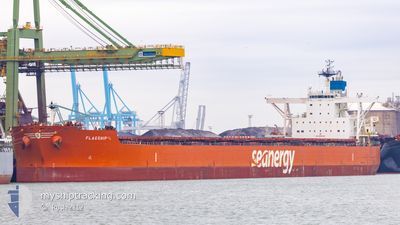
FLAGSHIP
Cargo
Current Trip
| Time Travelled | 20 days |
|---|---|
| Remaining Time | 10 days |
| Distance Travelled | 5623.90 nm |
| Remaining Distance | 2936.06 nm |
| AVG Speed | 11.3 Knots |
| MAX Speed | 15.9 Knots |
| AVG Wind | 15.4 knots |
| MAX Wind | 32 knots |
| MIN Temp | 15.9°C / 60.62°F |
| MAX Temp | 28.9°C / 84.02°F |
| Dybgang | 10.7 m |
| Position Modtaget | 9 h, 30 m siden |
Current Position
| Longitude | 14.52709° |
|---|---|
| Latitude | -33.85284° |
| Status | Under way using engine |
| Fart | 10.9 Knots |
| Kurs | 286.6° |
| Område | South Atlantic Ocean |
| Station | T-AIS |
| Position Modtaget | 9 h, 30 m siden |
Info
Information
The current position of FLAGSHIP is in South Atlantic Ocean with coordinates -33.85284° / 14.52709° as reported on 2025-03-20 06:26 by AIS to our vessel tracker app. The vessel's current speed is 10.9 Knots and is heading at the port of PONTA UBU. The estimated time of arrival as calculated by MyShipTracking vessel tracking app is 2025-03-30 13:04 LT
The vessel FLAGSHIP (IMO: 9514224, MMSI: 538009408) is a Cargo It's sailing under the flag of [MH] Marshall Is.
In this page you can find informations about the vessels current position, last detected port calls, and current voyage information. If the vessels is not in coverage by AIS you will find the latest position.
The current position of FLAGSHIP is detected by our AIS receivers and we are not responsible for the reliability of the data. The last position was recorded while the vessel was in Coverage by the Ais receivers of our vessel tracking app.
The current draught of FLAGSHIP as reported by AIS is 10.7 meters
Weather
| Temperature | 20.2°C / 68.36°F |
|---|---|
| Wind Speed | 11 knots |
| Direction | 126° SE |
| Pressure | 1014.7 hPa |
| Humidity | 83.7 % |
| Cloud Coverage | 94 % |
Featured Company
Events
| Tid | Hændelsen | Detaljer | Position / Dest | Info |
|---|---|---|---|---|
| 2025-03-20 06:30 | Status er ændret | Default Under way using engine |
-33.84893 / 14.51009
BR POU
|
Fart: 10.9 kn Kurs: 286.6° |
| 2025-03-20 06:26 | Status er ændret | Under way using engine Default |
-33.85284 / 14.52709
BR POU
|
Fart: 11.1 kn Kurs: 285° |
| 2025-03-20 06:26 | Udenfor Dækning |
-33.85284 / 14.52709
South Atlantic Ocean
BR POU
|
Fart: 10.9 kn Kurs: 286.6° |
|
| 2025-03-20 05:49 | Status er ændret | Default Under way using engine |
-33.88513 / 14.65755
BR POU
|
Fart: 11 kn Kurs: 287.3° |
| 2025-03-20 04:55 | Status er ændret | Under way using engine Default |
-33.93258 / 14.84507
BR POU
|
Fart: 10.7 kn Kurs: 288° |
| 2025-03-20 04:48 | Indenfor Dækning |
-33.93199 / 14.84278
South Atlantic Ocean
BR POU
|
Fart: 10.7 kn Kurs: 287.2° |
|
| 2025-03-20 02:43 | Status er ændret | Default Under way using engine |
-34.04046 / 15.30255
BR POU
|
Fart: 11 kn Kurs: 284° |
| 2025-03-20 02:37 | Udenfor Dækning |
-34.04530 / 15.32458
South Atlantic Ocean
BR POU
|
Fart: 11 kn Kurs: 284° |
|
| 2025-03-20 02:28 | Status er ændret | Under way using engine Default |
-34.05223 / 15.35652
BR POU
|
Fart: 11.1 kn Kurs: 284° |
| 2025-03-20 02:24 | Status er ændret | Default Under way using engine |
-34.05520 / 15.37018
BR POU
|
Fart: 11.2 kn Kurs: 284.4° |