
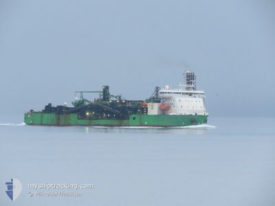
FLINTSTONE
Pipe Burying Vessel
Current Trip
| Time Travelled | --- |
|---|---|
| Remaining Time | --- |
| Distance Travelled | 1108.55 nm |
| Remaining Distance | --- |
| AVG Speed | 12.9 Knots |
| MAX Speed | 14.4 Knots |
| AVG Wind | 14.8 knots |
| MAX Wind | 18 knots |
| MIN Temp | 10.5°C / 50.9°F |
| MAX Temp | 23.5°C / 74.3°F |
| Dybgang | 7.3 m |
| Position Modtaget | 22 h, 52 m siden |
Current Position
| Longitude | -97.24019° |
|---|---|
| Latitude | 21.00057° |
| Status | Under way using engine |
| Fart | 13.3 Knots |
| Kurs | 93.3° |
| Område | Gulf of Mexico |
| Station | T-AIS |
| Position Modtaget | 22 h, 52 m siden |
Info
Information
The current position of FLINTSTONE is in Gulf of Mexico with coordinates 21.00057° / -97.24019° as reported on 2025-03-04 23:05 by AIS to our vessel tracker app. The vessel's current speed is 13.3 Knots
The vessel FLINTSTONE (IMO: 9528433, MMSI: 245861000) is a Pipe Burying Vessel that was built in 2011 ( 14 år gamle ). It's sailing under the flag of [NL] Netherlands.
In this page you can find informations about the vessels current position, last detected port calls, and current voyage information. If the vessels is not in coverage by AIS you will find the latest position.
The current position of FLINTSTONE is detected by our AIS receivers and we are not responsible for the reliability of the data. The last position was recorded while the vessel was in Coverage by the Ais receivers of our vessel tracking app.
The current draught of FLINTSTONE as reported by AIS is 7.3 meters
Weather
| Temperature | 24.5°C / 76.1°F |
|---|---|
| Wind Speed | 9 knots |
| Direction | 128° SE |
| Pressure | 1002.1 hPa |
| Humidity | 84 % |
| Cloud Coverage | 39 % |
Featured Company
Last Port Calls
Most Visited Ports (Last year)
| Port | Arrivals | |
|---|---|---|
| 14 | ||
| 8 | ||
| 3 | ||
| 2 | ||
| 1 | ||
| 1 |
Last Trips
| Origin | Departure | Destination | Arrival | Distance |
|---|
Events
| Tid | Hændelsen | Detaljer | Position / Dest | Info |
|---|---|---|---|---|
| 2025-03-04 23:05 | Udenfor Dækning |
21.00057 / -97.24019
Gulf of Mexico
OFFSHORE DOS BOCAS
|
Fart: 13.3 kn Kurs: 93.3° |
|
| 2025-03-04 22:52 | Status er ændret | Under way using engine Moored |
20.97925 / -97.28794
OFFSHORE DOS BOCAS
|
Fart: 12.7 kn Kurs: 59.3° |
| 2025-03-04 22:50 | Ændre havområde | Mexican part of the Gulf of Mexico United States part of the North Atlantic Ocean |
20.97506 / -97.29535
Gulf of Mexico
OFFSHORE DOS BOCAS
|
Fart: 11.7 kn Kurs: 61.5° |
| 2025-03-04 22:46 | Dybgangen er ændret | 7.3 6.6 |
20.97034 / -97.30478
OFFSHORE DOS BOCAS
|
Fart: 8.9 kn Kurs: 62° |
| 2025-03-04 22:46 | Destination er ændret | OFFSHORE DOS BOCAS MXTUX |
20.97034 / -97.30478
OFFSHORE DOS BOCAS
|
Fart: 8.9 kn Kurs: 62° |
| 2025-03-04 22:46 | ETA er ændret | 2025/03/05 09:00 2024/12/17 08:00 |
20.97034 / -97.30478
OFFSHORE DOS BOCAS
|
Fart: 8.9 kn Kurs: 62° |
| 2025-03-04 22:45 | Indenfor Dækning |
20.97097 / -97.30351
North Atlantic Ocean
OFFSHORE DOS BOCAS
|
Fart: 9.6 kn Kurs: 61.9° |