
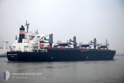
GLORIOUS SAKURA
Wood Chips Carrier
Current Trip
| Trip Time | 29 days |
|---|---|
| Trip Distance | 6045.92 nm |
| AVG Speed | 11.6 Knots |
| MAX Speed | 15.9 Knots |
| Dybgang | 7.5 m |
| AVG Wind | 11.6 knots |
| MAX Wind | 30.8 knots |
| MIN Temp | 3.8°C / 38.84°F |
| MAX Temp | 28.6°C / 83.48°F |
| Position Modtaget | 2025-01-02 01:02 |
Current Position
| Longitude | 121.03870° |
|---|---|
| Latitude | 25.44704° |
| Status | Under way using engine |
| Fart | 14.4 Knots |
| Kurs | 215.7° |
| Område | Eastern China Sea |
| Station | T-AIS |
| Position Modtaget | 2025-01-02 01:02 |
Info
Information
The current position of GLORIOUS SAKURA is in Eastern China Sea with coordinates 25.44704° / 121.03870° as reported on 2025-01-02 01:02 by AIS to our vessel tracker app. The vessel's current speed is 14.4 Knots and is currently inside the port of SAKAIMINATO.
The vessel GLORIOUS SAKURA (IMO: 9363699, MMSI: 370962000) is a Wood Chips Carrier that was built in 2009 ( 16 år gamle ). It's sailing under the flag of [PA] Panama.
In this page you can find informations about the vessels current position, last detected port calls, and current voyage information. If the vessels is not in coverage by AIS you will find the latest position.
The current position of GLORIOUS SAKURA is detected by our AIS receivers and we are not responsible for the reliability of the data. The last position was recorded while the vessel was in Coverage by the Ais receivers of our vessel tracking app.
The current draught of GLORIOUS SAKURA as reported by AIS is 7.5 meters
Weather
| Temperature | 7.7°C / 45.86°F |
|---|---|
| Wind Speed | 20 knots |
| Direction | 77° ENE |
| Pressure | 1025.9 hPa |
| Humidity | 55.1 % |
| Cloud Coverage | 100 % |
Featured Company
Last Port Calls
| Port | Arrival | Departure | Time In Port |
|---|---|---|---|
| 2025-03-13 09:54 | |||
| 2025-02-07 12:13 | 2025-02-12 09:17 | 4 d |
Most Visited Ports (Last year)
| Port | Arrivals | |
|---|---|---|
| 6 | ||
| 4 | ||
| 4 | ||
| 1 | ||
| 1 | ||
| 1 |
Last Trips
| Origin | Departure | Destination | Arrival | Distance | |
|---|---|---|---|---|---|
| 2025-02-12 09:17 | 2025-03-13 09:54 | 6045.92 nm | |||
| 2024-12-30 10:29 | 2025-02-07 12:13 | 5346.00 nm |
Events
| Tid | Hændelsen | Detaljer | Position / Dest | Info |
|---|---|---|---|---|
| 2025-03-13 01:22 | STOP Sejllads |
35.54028 / 133.25664
[JP] SAKAIMINATO
|
Fart: 0.1 kn Kurs: 236° |
|
| 2025-03-13 00:54 | Skibe i havn |
|
35.54838 / 133.27109
[JP] SAKAIMINATO
|
Fart: 5.5 kn Kurs: 242° |
| 2025-03-13 00:42 | START Sejllads | 0.38 nm, South West of KAIZAKI |
35.55333 / 133.29297
ID KUM
|
Fart: 6.3 kn Kurs: 272° |
| 2025-03-12 23:57 | STOP Sejllads | 0.71 nm, South East of KAIZAKI |
35.54862 / 133.30624
ID KUM
|
Fart: 0.2 kn Kurs: 296° |
| 2025-03-07 10:57 | START Sejllads | 8.21 nm, East of WAILINGDING ISLAND |
22.15250 / 114.16014
ID KUM
|
Fart: 5.6 kn Kurs: 162° |
| 2025-03-07 01:18 | STOP Sejllads | 7.95 nm, South of HONG KONG |
22.15948 / 114.15506
ID KUM
|
Fart: Kurs: 114° |