
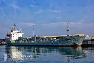
GRIT CEMENT II
Cement Carrier
Current Trip
| Trip Time | 3 days |
|---|---|
| Trip Distance | 148.74 nm |
| AVG Speed | 5.7 Knots |
| MAX Speed | 5.7 Knots |
| Dybgang | 7.9 m |
| AVG Wind | 5.6 knots |
| MAX Wind | 13 knots |
| MIN Temp | 14.3°C / 57.74°F |
| MAX Temp | 17.4°C / 63.32°F |
| Position Modtaget | 4 m siden |
Current Position
| Longitude | 35.03526° |
|---|---|
| Latitude | 32.81136° |
| Status | Moored |
| Fart | |
| Kurs | 65° |
| Område | Mediterranean Sea - Eastern Basin |
| Station | T-AIS |
| Position Modtaget | 4 m siden |
Info
Information
The current position of GRIT CEMENT II is in Mediterranean Sea - Eastern Basin with coordinates 32.81136° / 35.03526° as reported on 2025-02-05 01:31 by AIS to our vessel tracker app. The vessel's current speed is 0 Knots and is currently inside the port of HAIFA.
The vessel GRIT CEMENT II (IMO: 9064281, MMSI: 352534000) is a Cement Carrier that was built in 1992 ( 33 år gamle ). It's sailing under the flag of [PA] Panama.
In this page you can find informations about the vessels current position, last detected port calls, and current voyage information. If the vessels is not in coverage by AIS you will find the latest position.
The current position of GRIT CEMENT II is detected by our AIS receivers and we are not responsible for the reliability of the data. The last position was recorded while the vessel was in Coverage by the Ais receivers of our vessel tracking app.
The current draught of GRIT CEMENT II as reported by AIS is 7.9 meters
Weather
| Temperature | 14°C / 57.2°F |
|---|---|
| Wind Speed | 5 knots |
| Direction | 266° W |
| Pressure | 1013.7 hPa |
| Humidity | 75.8 % |
| Cloud Coverage | 27 % |
Featured Company
Last Port Calls
| Port | Arrival | Departure | Time In Port |
|---|---|---|---|
| 2025-02-04 08:40 | |||
| 2025-01-30 08:22 | 2025-02-01 06:44 | 1 d | |
| 2025-01-24 14:09 | 2025-01-27 00:35 | 2 d | |
| 2025-01-18 15:12 | 2025-01-22 12:12 | 3 d | |
| 2025-01-14 20:57 | 2025-01-17 04:52 | 2 d | |
| 2025-01-04 13:58 | 2025-01-08 12:12 | 3 d | |
| 2024-12-27 00:42 | 2024-12-28 11:41 | 1 d | |
| 2024-12-23 01:18 | 2024-12-24 15:46 | 1 d | |
| 2024-12-16 19:03 | 2024-12-19 06:48 | 2 d | |
| 2024-12-13 20:22 | 2024-12-16 01:21 | 2 d |
Last Trips
| Origin | Departure | Destination | Arrival | Distance | |
|---|---|---|---|---|---|
| 2025-02-01 08:44 | 2025-02-04 10:40 | 148.74 nm | |||
| 2025-01-27 02:35 | 2025-01-30 10:22 | 174.12 nm | |||
| 2025-01-22 14:12 | 2025-01-24 16:09 | 271.20 nm | |||
| 2025-01-17 06:52 | 2025-01-18 17:12 | 299.12 nm | |||
| 2025-01-08 14:12 | 2025-01-14 22:57 | 293.62 nm | |||
| 2024-12-28 13:41 | 2025-01-04 15:58 | 388.59 nm | |||
| 2024-12-24 17:46 | 2024-12-27 02:42 | 10.49 nm | |||
| 2024-12-19 08:48 | 2024-12-23 03:18 | 165.64 nm | |||
| 2024-12-16 03:21 | 2024-12-16 21:03 | 170.47 nm | |||
| 2024-12-11 15:19 | 2024-12-13 22:22 | 294.05 nm |
Events
| Tid | Hændelsen | Detaljer | Position / Dest | Info |
|---|---|---|---|---|
| 2025-02-04 14:17 | Status er ændret | Moored Default |
32.81134 / 35.03530
[IL] HAIFA
|
Fart: Kurs: 65° |
| 2025-02-04 13:40 | Status er ændret | Default Moored |
32.81137 / 35.03528
[IL] HAIFA
|
Fart: Kurs: 65° |
| 2025-02-04 09:09 | Status er ændret | Moored Under way using engine |
32.81137 / 35.03531
[IL] HAIFA
|
Fart: 0.1 kn Kurs: 64° |
| 2025-02-04 09:05 | STOP Sejllads |
32.81144 / 35.03524
[IL] HAIFA
|
Fart: 0.3 kn Kurs: 63° |
|
| 2025-02-04 08:40 | Skibe i havn |
|
32.83079 / 35.02037
[IL] HAIFA
|
Fart: 7.4 kn Kurs: 193.7° |
| 2025-02-04 08:25 | START Sejllads | 1.58 nm, North of HAIFA |
32.85596 / 35.01157
IL HFA
|
Fart: 3.2 kn Kurs: 148° |
| 2025-02-04 08:20 | STOP Sejllads | 1.69 nm, North of HAIFA |
32.85778 / 35.01168
IL HFA
|
Fart: 0.3 kn Kurs: 233° |
| 2025-02-04 07:51 | START Sejllads | 3.24 nm, North of HAIFA |
32.88162 / 34.99462
IL HFA
|
Fart: 4.1 kn Kurs: 184° |
| 2025-02-04 07:41 | Status er ændret | Under way using engine At anchor |
32.88404 / 34.99186
IL HFA
|
Fart: 0.9 kn Kurs: 8° |
| 2025-02-04 01:10 | Status er ændret | At anchor Default |
32.88307 / 34.99164
IL HFA
|
Fart: Kurs: 54° |