
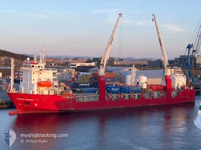
HANNAH KRISTINA
Ro-Ro Cargo
Current Trip
| Time Travelled | 1 day |
|---|---|
| Remaining Time | 13 h, 2 mins |
| Distance Travelled | 284.16 nm |
| Remaining Distance | 196.33 nm |
| AVG Speed | 14.2 Knots |
| MAX Speed | 15.3 Knots |
| AVG Wind | 8.6 knots |
| MAX Wind | 15 knots |
| MIN Temp | -16.8°C / 1.76°F |
| MAX Temp | -0.3°C / 31.46°F |
| Dybgang | 6.5 m |
| Position Modtaget | 2 m siden |
Current Position
| Longitude | 11.97686° |
|---|---|
| Latitude | 65.39074° |
| Status | Under way using engine |
| Fart | 13.8 Knots |
| Kurs | 158.4° |
| Område | Norwegian Sea |
| Station | T-AIS |
| Position Modtaget | 2 m siden |
Info
Information
The current position of HANNAH KRISTINA is in Norwegian Sea with coordinates 65.39074° / 11.97686° as reported on 2026-01-06 18:40 by AIS to our vessel tracker app. The vessel's current speed is 13.8 Knots and is heading at the port of KRISTIANSUND. The estimated time of arrival as calculated by MyShipTracking vessel tracking app is 2026-01-07 07:44 LT
The vessel HANNAH KRISTINA (IMO: 9159933, MMSI: 257130000) is a Ro-Ro Cargo that was built in 1999 ( 27 år gamle ). It's sailing under the flag of [NO] Norway.
In this page you can find informations about the vessels current position, last detected port calls, and current voyage information. If the vessels is not in coverage by AIS you will find the latest position.
The current position of HANNAH KRISTINA is detected by our AIS receivers and we are not responsible for the reliability of the data. The last position was recorded while the vessel was in Coverage by the Ais receivers of our vessel tracking app.
The current draught of HANNAH KRISTINA as reported by AIS is 6.5 meters
Weather
| Temperature | -2.6°C / 27.32°F |
|---|---|
| Wind Speed | 11 knots |
| Direction | 140° SE |
| Pressure | 1015.8 hPa |
| Humidity | 71.2 % |
| Cloud Coverage | 100 % |
Featured Company
Last Port Calls
| Port | Arrival | Departure | Time In Port |
|---|---|---|---|
| 2026-01-05 03:26 | 2026-01-05 16:15 | 12 h | |
| 2026-01-04 04:13 | 2026-01-04 06:09 | 1 h | |
| 2026-01-02 23:58 | 2026-01-03 14:07 | 14 h | |
| 2026-01-02 18:36 | 2026-01-02 23:06 | 4 h | |
| 2025-12-31 05:10 | 2026-01-02 17:35 | 2 d | |
| 2025-12-29 06:00 | 2025-12-29 17:18 | 11 h | |
| 2025-12-26 10:31 | 2025-12-27 16:42 | 1 d | |
| 2025-12-26 04:47 | 2025-12-26 09:40 | 4 h | |
| 2025-12-22 12:03 | 2025-12-22 22:40 | 10 h | |
| 2025-12-19 06:32 | 2025-12-20 20:40 | 1 d |
Last Trips
| Origin | Departure | Destination | Arrival | Distance | |
|---|---|---|---|---|---|
| 2026-01-04 07:09 | 2026-01-05 04:26 | 239.67 nm | |||
| 2026-01-03 15:07 | 2026-01-04 05:13 | 113.77 nm | |||
| 2026-01-03 00:06 | 2026-01-03 00:58 | 11.86 nm | |||
| 2026-01-02 18:35 | 2026-01-02 19:36 | 11.89 nm | |||
| 2025-12-29 18:18 | 2025-12-31 06:10 | 345.51 nm | |||
| 2025-12-27 17:42 | 2025-12-29 07:00 | 348.62 nm | |||
| 2025-12-26 10:40 | 2025-12-26 11:31 | 12.32 nm | |||
| 2025-12-22 23:40 | 2025-12-26 05:47 | 812.91 nm | |||
| 2025-12-20 21:40 | 2025-12-22 13:03 | 344.12 nm | |||
| 2025-12-19 06:29 | 2025-12-19 07:32 | 13.10 nm |
Events
| Tid | Hændelsen | Detaljer | Position / Dest | Info |
|---|---|---|---|---|
| 2026-01-06 15:32 | START Sejllads | 0.36 nm, East of SANDNESSJOEN |
66.02673 / 12.65654
NOKSU
|
Fart: 7.6 kn Kurs: 291° |
| 2026-01-06 15:11 | Status er ændret | Under way using engine Moored |
66.02479 / 12.66636
NOKSU
|
Fart: Kurs: 239° |
| 2026-01-06 14:51 | Status er ændret | Moored Under way using engine |
66.02481 / 12.66643
NOKSU
|
Fart: Kurs: 240° |
| 2026-01-06 14:47 | Destination er ændret | NOKSU NOSSJ |
66.02485 / 12.66647
NOKSU
|
Fart: Kurs: 240° |
| 2026-01-06 14:47 | ETA er ændret | 2026/01/07 12:00 2026/01/06 10:00 |
66.02485 / 12.66647
NOKSU
|
Fart: Kurs: 240° |
| 2026-01-06 09:04 | STOP Sejllads | 0.61 nm, East of SANDNESSJOEN |
66.02489 / 12.66679
NOSSJ
|
Fart: 0.1 kn Kurs: 241° |
| 2026-01-05 17:03 | Status er ændret | Under way using engine Moored |
63.20785 / 7.89659
NOSSJ
|
Fart: 14.5 kn Kurs: 59.5° |
| 2026-01-05 17:03 | Destination er ændret | NOSSJ KRISTIANSUND |
63.20368 / 7.88102
NOSSJ
|
Fart: 14.5 kn Kurs: 59.5° |
| 2026-01-05 17:03 | ETA er ændret | 2026/01/06 10:00 2026/01/05 08:30 |
63.20368 / 7.88102
NOSSJ
|
Fart: 14.5 kn Kurs: 59.5° |
| 2026-01-05 16:15 | Afsejlet fra sidste havn |
|
63.10073 / 7.76338
KRISTIANSUND
|
Fart: 6.8 kn Kurs: 253° |