
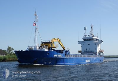
HAV SAGA
General Cargo
Current Trip
| Time Travelled | 10 days |
|---|---|
| Remaining Time | 2 h, 29 mins |
| Distance Travelled | 1393.16 nm |
| Remaining Distance | 27.88 nm |
| AVG Speed | 9.1 Knots |
| MAX Speed | 18.1 Knots |
| AVG Wind | 8.3 knots |
| MAX Wind | 33 knots |
| MIN Temp | -1.5°C / 29.3°F |
| MAX Temp | 8.2°C / 46.76°F |
| Dybgang | 5.6 m |
| Position Modtaget | 1 m siden |
Current Position
| Longitude | 8.27389° |
|---|---|
| Latitude | 63.31393° |
| Status | Under way using engine |
| Fart | 10.7 Knots |
| Kurs | 41.7° |
| Område | Norwegian Sea |
| Station | T-AIS |
| Position Modtaget | 1 m siden |
Info
Information
The current position of HAV SAGA is in Norwegian Sea with coordinates 63.31393° / 8.27389° as reported on 2025-03-20 22:34 by AIS to our vessel tracker app. The vessel's current speed is 10.7 Knots and is heading at the port of HALSA. The estimated time of arrival as calculated by MyShipTracking vessel tracking app is 2025-03-21 02:05 LT
The vessel HAV SAGA (IMO: 8719073, MMSI: 231108000) is a General Cargo that was built in 1990 ( 35 år gamle ). It's sailing under the flag of [FO] Faroe Is.
In this page you can find informations about the vessels current position, last detected port calls, and current voyage information. If the vessels is not in coverage by AIS you will find the latest position.
The current position of HAV SAGA is detected by our AIS receivers and we are not responsible for the reliability of the data. The last position was recorded while the vessel was in Coverage by the Ais receivers of our vessel tracking app.
The current draught of HAV SAGA as reported by AIS is 5.6 meters
Weather
| Temperature | 2.2°C / 35.96°F |
|---|---|
| Wind Speed | 8 knots |
| Direction | 145° SE |
| Pressure | 1021.9 hPa |
| Humidity | 81.8 % |
| Cloud Coverage | 58 % |
Featured Company
Last Port Calls
| Port | Arrival | Departure | Time In Port |
|---|---|---|---|
| 2025-03-08 22:07 | 2025-03-10 18:14 | 1 d | |
| 2025-03-06 20:07 | 2025-03-07 20:20 | 1 d | |
| 2025-02-28 02:46 | 2025-03-01 00:05 | 21 h | |
| 2025-02-17 07:51 | 2025-02-18 00:43 | 16 h | |
| 2025-02-12 01:58 | 2025-02-12 16:49 | 14 h | |
| 2025-02-06 10:25 | 2025-02-07 01:25 | 14 h | |
| 2025-02-02 06:44 | 2025-02-03 01:03 | 18 h | |
| 2025-01-29 07:07 | 2025-01-30 23:02 | 1 d | |
| 2025-01-23 20:34 | 2025-01-25 19:48 | 1 d | |
| 2025-01-23 00:38 | 2025-01-23 01:15 | 37 m |
Last Trips
| Origin | Departure | Destination | Arrival | Distance | |
|---|---|---|---|---|---|
| 2025-03-07 20:20 | 2025-03-08 22:07 | 259.21 nm | |||
| 2025-03-01 00:05 | 2025-03-06 20:07 | 977.03 nm | |||
| 2025-02-18 00:43 | 2025-02-28 02:46 | 1481.94 nm | |||
| 2025-02-12 16:49 | 2025-02-17 07:51 | 1025.96 nm | |||
| 2025-02-07 01:25 | 2025-02-12 01:58 | 980.64 nm | |||
| 2025-02-03 01:03 | 2025-02-06 10:25 | 376.34 nm | |||
| 2025-01-30 23:02 | 2025-02-02 06:44 | 491.81 nm | |||
| 2025-01-25 19:48 | 2025-01-29 07:07 | 736.58 nm | |||
| 2025-01-23 01:15 | 2025-01-23 20:34 | 153.72 nm | |||
| 2025-01-22 14:30 | 2025-01-23 00:38 | 84.42 nm |
Events
| Tid | Hændelsen | Detaljer | Position / Dest | Info |
|---|---|---|---|---|
| 2025-03-20 05:50 | ETA er ændret | 2025/03/22 04:00 2025/03/22 08:00 |
61.62531 / 4.97989
HALSA
|
Fart: 9.8 kn Kurs: 4.1° |
| 2025-03-20 05:47 | Status er ændret | Under way using engine Default |
61.61947 / 4.97911
HALSA
|
Fart: 9.9 kn Kurs: 23° |
| 2025-03-20 05:45 | Status er ændret | Default Under way using engine |
61.61504 / 4.97661
HALSA
|
Fart: 9.9 kn Kurs: 25.8° |
| 2025-03-20 01:19 | Ændre havområde | Norwegian part of the Norwegian Sea Norwegian part of the North Sea |
61.00057 / 4.81031
Norwegian Sea
HALSA
|
Fart: 10.5 kn Kurs: 53.8° |
| 2025-03-19 14:09 | START Sejllads | 0.58 nm, South of VORMEDAL |
59.34387 / 5.31325
HALSA
|
Fart: 5.7 kn Kurs: 1.6° |
| 2025-03-19 13:39 | STOP Sejllads | 0.61 nm, North East of HUSOYA |
59.34216 / 5.31191
HALSA
|
Fart: 0.2 kn Kurs: 194° |
| 2025-03-19 06:38 | START Sejllads | 0.88 nm, South of EGERSUND |
58.43712 / 5.98721
HALSA
|
Fart: 3.8 kn Kurs: 144° |
| 2025-03-19 06:17 | Status er ændret | Under way using engine Moored |
58.43865 / 5.97931
HALSA
|
Fart: Kurs: 359° |
| 2025-03-19 05:44 | Dybgangen er ændret | 5.6 4.6 |
58.43865 / 5.97923
HALSA
|
Fart: Kurs: 359° |
| 2025-03-19 05:42 | Destination er ændret | HALSA EGERSUND |
58.43865 / 5.97923
HALSA
|
Fart: Kurs: 359° |