
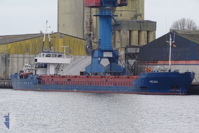
HELGA
General Cargo
Current Trip
| Trip Time | 2 days |
|---|---|
| Trip Distance | 492.87 nm |
| AVG Speed | 7.5 Knots |
| MAX Speed | 8.4 Knots |
| Dybgang | 4 m |
| AVG Wind | 14.5 knots |
| MAX Wind | 20 knots |
| MIN Temp | -0.5°C / 31.1°F |
| MAX Temp | 2°C / 35.6°F |
| Position Modtaget | 1 m siden |
Current Position
| Longitude | 21.13188° |
|---|---|
| Latitude | 55.69617° |
| Status | Moored |
| Fart | |
| Kurs | 338° |
| Område | Baltic Sea |
| Station | T-AIS |
| Position Modtaget | 1 m siden |
Info
Information
The current position of HELGA is in Baltic Sea with coordinates 55.69617° / 21.13188° as reported on 2025-02-03 13:54 by AIS to our vessel tracker app. The vessel's current speed is 0 Knots and is currently inside the port of KLAIPEDA.
The vessel HELGA (IMO: 8402577, MMSI: 341832000) is a General Cargo that was built in 1984 ( 41 år gamle ). It's sailing under the flag of [KN] St Kitts Nevis.
In this page you can find informations about the vessels current position, last detected port calls, and current voyage information. If the vessels is not in coverage by AIS you will find the latest position.
The current position of HELGA is detected by our AIS receivers and we are not responsible for the reliability of the data. The last position was recorded while the vessel was in Coverage by the Ais receivers of our vessel tracking app.
The current draught of HELGA as reported by AIS is 4 meters
Weather
| Temperature | 1.6°C / 34.88°F |
|---|---|
| Wind Speed | 13 knots |
| Direction | 324° NW |
| Pressure | 1024.7 hPa |
| Humidity | 74.4 % |
| Cloud Coverage | 100 % |
Featured Company
Last Port Calls
| Port | Arrival | Departure | Time In Port |
|---|---|---|---|
| 2025-02-03 12:33 | |||
| 2025-01-30 06:37 | 2025-01-31 18:53 | 1 d | |
| 2025-01-30 04:46 | |||
| 2025-01-09 19:12 |
Most Visited Ports (Last year)
| Port | Arrivals | |
|---|---|---|
| 11 | ||
| 10 | ||
| 7 | ||
| 4 | ||
| 2 | ||
| 2 |
Last Trips
| Origin | Departure | Destination | Arrival | Distance | |
|---|---|---|---|---|---|
| 2025-01-31 21:53 | 2025-02-03 14:33 | 492.87 nm | |||
| 2025-01-30 07:46 | 2025-01-30 09:37 | 4.85 nm |
Events
| Tid | Hændelsen | Detaljer | Position / Dest | Info |
|---|---|---|---|---|
| 2025-02-03 13:54 | Status er ændret | Moored Default |
55.69617 / 21.13188
[LT] KLAIPEDA
|
Fart: Kurs: 338° |
| 2025-02-03 13:51 | Status er ændret | Default Moored |
55.69618 / 21.13188
[LT] KLAIPEDA
|
Fart: Kurs: 339° |
| 2025-02-03 13:42 | Status er ændret | Moored Default |
55.69618 / 21.13188
[LT] KLAIPEDA
|
Fart: Kurs: 339° |
| 2025-02-03 13:27 | Status er ændret | Default Moored |
55.69618 / 21.13187
[LT] KLAIPEDA
|
Fart: Kurs: 339° |
| 2025-02-03 13:09 | Status er ændret | Moored Under way using engine |
55.69618 / 21.13189
[LT] KLAIPEDA
|
Fart: Kurs: 339° |
| 2025-02-03 13:05 | STOP Sejllads |
55.69617 / 21.13189
[LT] KLAIPEDA
|
Fart: 0.3 kn Kurs: 338° |
|
| 2025-02-03 12:33 | Skibe i havn |
|
55.72448 / 21.09357
[LT] KLAIPEDA
|
Fart: 7.3 kn Kurs: 120.7° |
| 2025-02-03 11:39 | Status er ændret | Under way using engine Default |
55.78640 / 20.92373
LT KLJ
|
Fart: 7.8 kn Kurs: 134° |
| 2025-02-03 11:29 | Status er ændret | Default Under way using engine |
55.80089 / 20.89574
LT KLJ
|
Fart: 7.8 kn Kurs: 138° |
| 2025-02-03 11:23 | Ændre havområde | Lithuanian part of the Baltic Sea Finnish part of the Baltic Sea |
55.80994 / 20.87818
Baltic Sea
LT KLJ
|
Fart: 7.8 kn Kurs: 138° |