
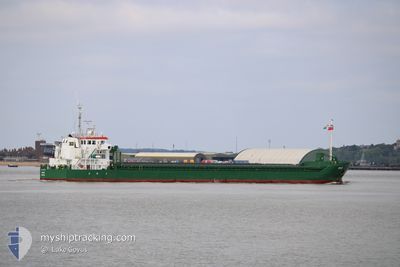
HELGE
General Cargo
Current Trip
| Time Travelled | 12 h, 26 mins |
|---|---|
| Remaining Time | 15 h, 15 mins |
| Distance Travelled | 131.98 nm |
| Remaining Distance | 181.83 nm |
| AVG Speed | 11 Knots |
| MAX Speed | 13.5 Knots |
| AVG Wind | 11.2 knots |
| MAX Wind | 18 knots |
| MIN Temp | -1.5°C / 29.3°F |
| MAX Temp | 3.6°C / 38.48°F |
| Dybgang | 3.7 m |
| Position Modtaget | 1 h, 15 m siden |
Current Position
| Longitude | 4.27318° |
|---|---|
| Latitude | 53.11153° |
| Status | Under way using engine |
| Fart | 11.5 Knots |
| Kurs | 232.9° |
| Område | North Sea |
| Station | T-AIS |
| Position Modtaget | 1 h, 15 m siden |
Info
Information
The current position of HELGE is in North Sea with coordinates 53.11153° / 4.27318° as reported on 2025-02-13 19:13 by AIS to our vessel tracker app. The vessel's current speed is 11.5 Knots and is heading at the port of TILBURY. The estimated time of arrival as calculated by MyShipTracking vessel tracking app is 2025-02-14 11:44 LT
The vessel HELGE (IMO: 9677404, MMSI: 244750397) is a General Cargo that was built in 2013 ( 12 år gamle ). It's sailing under the flag of [NL] Netherlands.
In this page you can find informations about the vessels current position, last detected port calls, and current voyage information. If the vessels is not in coverage by AIS you will find the latest position.
The current position of HELGE is detected by our AIS receivers and we are not responsible for the reliability of the data. The last position was recorded while the vessel was in Coverage by the Ais receivers of our vessel tracking app.
The current draught of HELGE as reported by AIS is 3.7 meters
Weather
| Temperature | 3.8°C / 38.84°F |
|---|---|
| Wind Speed | 13 knots |
| Direction | 59° ENE |
| Pressure | 1024.5 hPa |
| Humidity | 63 % |
| Cloud Coverage | 100 % |
Featured Company
Last Port Calls
| Port | Arrival | Departure | Time In Port |
|---|---|---|---|
| 2025-02-10 17:59 | 2025-02-13 08:03 | 2 d | |
| 2025-01-05 00:05 | 2025-02-10 14:49 | ||
| 2024-12-28 06:31 | 2025-01-04 09:59 | 7 d | |
| 2024-12-23 15:36 | |||
| 2024-12-19 04:40 | 2024-12-19 15:29 | 10 h | |
| 2024-12-15 18:09 | 2024-12-16 20:01 | 1 d | |
| 2024-12-10 09:55 | 2024-12-10 12:44 | 2 h | |
| 2024-12-07 04:40 | 2024-12-07 14:48 | 10 h | |
| 2024-12-01 06:42 |
Most Visited Ports (Last year)
| Port | Arrivals | |
|---|---|---|
| 8 | ||
| 7 | ||
| 6 | ||
| 6 | ||
| 4 | ||
| 4 |
Last Trips
| Origin | Departure | Destination | Arrival | Distance | |
|---|---|---|---|---|---|
| 2025-02-10 15:49 | 2025-02-10 18:59 | 29.27 nm | |||
| 2025-01-04 10:59 | 2025-01-05 01:05 | 135.10 nm | |||
| 2024-12-23 16:36 | 2024-12-28 07:31 | 511.97 nm | |||
| 2024-12-16 21:01 | 2024-12-19 05:40 | 395.01 nm | |||
| 2024-12-10 13:44 | 2024-12-15 19:09 | 969.57 nm | |||
| 2024-12-07 15:48 | 2024-12-10 10:55 | 684.80 nm | |||
| 2024-12-01 08:42 | 2024-12-07 05:40 | 980.82 nm |
Events
| Tid | Hændelsen | Detaljer | Position / Dest | Info |
|---|---|---|---|---|
| 2025-02-13 19:31 | Status er ændret | Default Under way using engine |
53.07515 / 4.19738
TILBURY
|
Fart: 11.5 kn Kurs: 232.9° |
| 2025-02-13 19:13 | Udenfor Dækning |
53.11153 / 4.27318
North Sea
TILBURY
|
Fart: 11.5 kn Kurs: 232.9° |
|
| 2025-02-13 18:16 | Status er ændret | Under way using engine Default |
53.24943 / 4.45228
TILBURY
|
Fart: 11.1 kn Kurs: 204° |
| 2025-02-13 18:06 | Indenfor Dækning |
53.24712 / 4.45042
North Sea
TILBURY
|
Fart: 11 kn Kurs: 205.7° |
|
| 2025-02-13 16:03 | Status er ændret | Default Under way using engine |
53.52628 / 4.89846
TILBURY
|
Fart: 12.5 kn Kurs: 250.6° |
| 2025-02-13 16:01 | Udenfor Dækning |
53.52848 / 4.90939
North Sea
TILBURY
|
Fart: 12.5 kn Kurs: 250.6° |
|
| 2025-02-13 13:01 | ETA er ændret | 2025/02/14 15:00 2025/02/14 12:00 |
53.73803 / 5.94427
TILBURY
|
Fart: 12.9 kn Kurs: 253.4° |
| 2025-02-13 12:47 | Status er ændret | Under way using engine Default |
53.75295 / 6.02441
TILBURY
|
Fart: 10.4 kn Kurs: 251° |
| 2025-02-13 12:45 | Status er ændret | Default Under way using engine |
53.75453 / 6.03300
TILBURY
|
Fart: 11.6 kn Kurs: 253° |
| 2025-02-13 12:41 | Ændre havområde | Dutch part of the North Sea German part of the North Sea |
53.75795 / 6.05161
North Sea
TILBURY
|
Fart: 11.6 kn Kurs: 253° |