
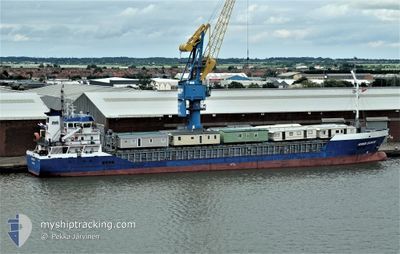
HILDA B
General Cargo
Current Trip
| Time Travelled | 3 days |
|---|---|
| Remaining Time | 13 h, 55 mins |
| Distance Travelled | 552.93 nm |
| Remaining Distance | 284.53 nm |
| AVG Speed | 9.9 Knots |
| MAX Speed | 11.6 Knots |
| AVG Wind | 11.1 knots |
| MAX Wind | 24.7 knots |
| MIN Temp | 1.9°C / 35.42°F |
| MAX Temp | 6.4°C / 43.52°F |
| Dybgang | 5.5 m |
| Position Modtaget | 19 h, 33 m siden |
Current Position
| Longitude | 5.44133° |
|---|---|
| Latitude | 57.30875° |
| Status | Under way using engine |
| Fart | 7.3 Knots |
| Kurs | 260.6° |
| Område | North Sea |
| Station | T-AIS |
| Position Modtaget | 19 h, 33 m siden |
Info
Information
The current position of HILDA B is in North Sea with coordinates 57.30875° / 5.44133° as reported on 2025-03-02 21:22 by AIS to our vessel tracker app. The vessel's current speed is 7.3 Knots and is heading at the port of DUNDEE. The estimated time of arrival as calculated by MyShipTracking vessel tracking app is 2025-03-04 06:50 LT
The vessel HILDA B (IMO: 9466233, MMSI: 210525000) is a General Cargo that was built in 2011 ( 14 år gamle ). It's sailing under the flag of [CY] Cyprus.
In this page you can find informations about the vessels current position, last detected port calls, and current voyage information. If the vessels is not in coverage by AIS you will find the latest position.
The current position of HILDA B is detected by our AIS receivers and we are not responsible for the reliability of the data. The last position was recorded while the vessel was in Coverage by the Ais receivers of our vessel tracking app.
The current draught of HILDA B as reported by AIS is 5.5 meters
Weather
| Temperature | 7.1°C / 44.78°F |
|---|---|
| Wind Speed | 12 knots |
| Direction | 265° W |
| Pressure | 1022.8 hPa |
| Humidity | 92.8 % |
| Cloud Coverage | 100 % |
Featured Company
Last Port Calls
| Port | Arrival | Departure | Time In Port |
|---|---|---|---|
| 2025-02-27 04:13 | 2025-02-28 12:06 | 1 d | |
| 2025-02-24 17:03 | 2025-02-26 13:21 | 1 d | |
| 2025-02-16 20:23 | 2025-02-18 19:37 | 1 d | |
| 2025-02-13 17:10 | 2025-02-14 17:48 | 1 d | |
| 2025-02-06 02:36 | 2025-02-11 00:22 | 4 d | |
| 2025-01-24 15:12 | 2025-02-03 17:24 | 10 d | |
| 2025-01-23 06:09 | 2025-01-24 14:51 | 1 d | |
| 2025-01-21 10:29 | 2025-01-21 23:19 | 12 h | |
| 2025-01-15 14:30 | 2025-01-17 17:00 | 2 d | |
| 2025-01-13 04:24 | 2025-01-13 13:46 | 9 h |
Last Trips
| Origin | Departure | Destination | Arrival | Distance | |
|---|---|---|---|---|---|
| 2025-02-26 14:21 | 2025-02-27 05:13 | 132.00 nm | |||
| 2025-02-18 19:37 | 2025-02-24 18:03 | 872.57 nm | |||
| 2025-02-14 18:48 | 2025-02-16 20:23 | 535.79 nm | |||
| 2025-02-11 00:22 | 2025-02-13 18:10 | 524.56 nm | |||
| 2025-02-03 18:24 | 2025-02-06 02:36 | 406.97 nm | |||
| 2025-01-24 15:51 | 2025-01-24 16:12 | 1.83 nm | |||
| 2025-01-22 00:19 | 2025-01-23 07:09 | 332.47 nm | |||
| 2025-01-17 17:00 | 2025-01-21 11:29 | 153.43 nm | |||
| 2025-01-13 13:46 | 2025-01-15 14:30 | 393.75 nm | |||
| 2025-01-08 23:03 | 2025-01-13 04:24 | 842.66 nm |
Events
| Tid | Hændelsen | Detaljer | Position / Dest | Info |
|---|---|---|---|---|
| 2025-03-02 21:33 | Status er ændret | Default Under way using engine |
57.30434 / 5.39762
GBDUN
|
Fart: 7.3 kn Kurs: 260.6° |
| 2025-03-02 21:22 | Udenfor Dækning |
57.30875 / 5.44133
North Sea
GBDUN
|
Fart: 7.3 kn Kurs: 260.6° |
|
| 2025-03-02 12:25 | Ændre havområde | Norwegian part of the North Sea Norwegian part of the Skaggerak |
57.56114 / 7.79070
North Sea
GBDUN
|
Fart: 9.6 kn Kurs: 259.7° |
| 2025-03-02 09:52 | Ændre havområde | Norwegian part of the Skaggerak Danish part of the Skaggerak |
57.62368 / 8.48740
Skaggerak
GBDUN
|
Fart: 8.5 kn Kurs: 256.4° |
| 2025-03-02 00:38 | Ændre havområde | Danish part of the Skaggerak Danish part of the Kattegat |
57.80203 / 10.92164
Skaggerak
GBDUN
|
Fart: 9 kn Kurs: 317.7° |
| 2025-03-01 21:17 | Fundet i havområde | Danish part of the Kattegat |
57.34804 / 11.47813
Kattegat
GBDUN
|
Fart: 9.9 kn Kurs: 326.5° |
| 2025-03-01 13:14 | Ændre havområde | Swedish part of the Kattegat Danish part of the Kattegat |
56.13215 / 12.51951
Kattegat
GBDUN
|
Fart: 9.8 kn Kurs: 319.2° |
| 2025-03-01 12:56 | Ændre havområde | Danish part of the Kattegat Swedish part of the Kattegat |
56.09633 / 12.57979
Kattegat
GBDUN
|
Fart: 9.7 kn Kurs: 314.2° |
| 2025-03-01 11:10 | Ændre havområde | Swedish part of the Kattegat Danish part of the Kattegat |
55.82143 / 12.72021
Kattegat
GBDUN
|
Fart: 10.5 kn Kurs: 5.1° |
| 2025-03-01 09:14 | Ændre havområde | Danish part of the Kattegat Swedish part of the Kattegat |
55.48662 / 12.70965
Kattegat
GBDUN
|
Fart: 10.2 kn Kurs: 5° |