
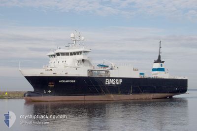
HOLMFOSS
Reefer
Current Trip
| Time Travelled | 2 days |
|---|---|
| Remaining Time | 2 h, 55 mins |
| Distance Travelled | 586.46 nm |
| Remaining Distance | 24.87 nm |
| AVG Speed | 9.2 Knots |
| MAX Speed | 14.3 Knots |
| AVG Wind | 22.3 knots |
| MAX Wind | 36.5 knots |
| MIN Temp | 3.9°C / 39.02°F |
| MAX Temp | 10.3°C / 50.54°F |
| Dybgang | 6 m |
| Position Modtaget | 21 m siden |
Current Position
| Longitude | 0.25178° |
|---|---|
| Latitude | 53.69741° |
| Status | Under way using engine |
| Fart | 4.1 Knots |
| Kurs | 5° |
| Område | North Sea |
| Station | T-AIS |
| Position Modtaget | 21 m siden |
Info
Information
The current position of HOLMFOSS is in North Sea with coordinates 53.69741° / 0.25178° as reported on 2025-12-16 11:33 by AIS to our vessel tracker app. The vessel's current speed is 4.1 Knots and is heading at the port of GRIMSBY. The estimated time of arrival as calculated by MyShipTracking vessel tracking app is 2025-12-16 14:50 LT
The vessel HOLMFOSS (IMO: 9359662, MMSI: 257302000) is a Reefer that was built in 2007 ( 18 år gamle ). It's sailing under the flag of [NO] Norway.
In this page you can find informations about the vessels current position, last detected port calls, and current voyage information. If the vessels is not in coverage by AIS you will find the latest position.
The current position of HOLMFOSS is detected by our AIS receivers and we are not responsible for the reliability of the data. The last position was recorded while the vessel was in Coverage by the Ais receivers of our vessel tracking app.
The current draught of HOLMFOSS as reported by AIS is 6 meters
Weather
| Temperature | 7.7°C / 45.86°F |
|---|---|
| Wind Speed | 11 knots |
| Direction | 10° N |
| Pressure | 1009.3 hPa |
| Humidity | 90.5 % |
| Cloud Coverage | 100 % |
Featured Company
Last Port Calls
| Port | Arrival | Departure | Time In Port |
|---|---|---|---|
| 2025-12-13 20:30 | 2025-12-13 21:30 | 59 m | |
| 2025-12-13 12:21 | 2025-12-13 13:38 | 1 h | |
| 2025-12-13 05:12 | 2025-12-13 06:03 | 50 m | |
| 2025-12-13 04:04 | 2025-12-13 04:56 | 51 m | |
| 2025-12-12 02:24 | 2025-12-12 02:36 | 12 m | |
| 2025-12-11 08:44 | 2025-12-11 12:15 | 3 h | |
| 2025-12-11 01:12 | 2025-12-11 03:31 | 2 h | |
| 2025-12-10 22:26 | 2025-12-10 23:44 | 1 h | |
| 2025-12-08 22:48 | 2025-12-08 23:03 | 14 m | |
| 2025-12-08 20:33 | 2025-12-08 20:58 | 25 m |
Last Trips
| Origin | Departure | Destination | Arrival | Distance | |
|---|---|---|---|---|---|
| 2025-12-13 13:38 | 2025-12-13 20:30 | 2.70 nm | |||
| 2025-12-13 06:03 | 2025-12-13 12:21 | 66.33 nm | |||
| 2025-12-13 04:56 | 2025-12-13 05:12 | 1.26 nm | |||
| 2025-12-12 02:36 | 2025-12-13 04:04 | 215.85 nm | |||
| 2025-12-11 12:15 | 2025-12-12 02:24 | 189.01 nm | |||
| 2025-12-11 03:31 | 2025-12-11 08:44 | 73.38 nm | |||
| 2025-12-10 23:44 | 2025-12-11 01:12 | 20.00 nm | |||
| 2025-12-08 23:03 | 2025-12-10 22:26 | 277.60 nm | |||
| 2025-12-08 20:58 | 2025-12-08 22:48 | 25.61 nm | |||
| 2025-12-08 13:57 | 2025-12-08 20:33 | 93.13 nm |
Events
| Tid | Hændelsen | Detaljer | Position / Dest | Info |
|---|---|---|---|---|
| 2025-12-16 11:50 | Status er ændret | Default Under way using engine |
53.70539 / .28959
GRIMSBY UK
|
Fart: 5.5 kn Kurs: 81.7° |
| 2025-12-16 11:48 | Status er ændret | Under way using engine Default |
53.70529 / .28429
GRIMSBY UK
|
Fart: 5.5 kn Kurs: 79° |
| 2025-12-16 11:34 | Status er ændret | Default Under way using engine |
53.69833 / .25227
GRIMSBY UK
|
Fart: 4.1 kn Kurs: 5° |
| 2025-12-16 11:33 | Ændre havområde | United Kingdom part of the North Sea Norwegian part of the North Sea |
53.69741 / .25178
North Sea
GRIMSBY UK
|
Fart: 4.1 kn Kurs: 12° |
| 2025-12-16 11:33 | Status er ændret | Under way using engine Default |
53.69704 / .25167
GRIMSBY UK
|
Fart: 4.2 kn Kurs: 326° |
| 2025-12-16 11:14 | Indenfor Dækning |
53.69741 / .25178
North Sea
GRIMSBY UK
|
Fart: 4.1 kn Kurs: 12° |
|
| 2025-12-15 09:07 | Status er ændret | Default Under way using engine |
58.13970 / 4.18018
GRIMSBY UK
|
Fart: 10.4 kn Kurs: 244.5° |
| 2025-12-15 09:02 | Status er ændret | Under way using engine Default |
58.14490 / 4.20240
GRIMSBY UK
|
Fart: 9.7 kn Kurs: 252° |
| 2025-12-15 09:02 | Udenfor Dækning |
58.14490 / 4.20240
North Sea
GRIMSBY UK
|
Fart: 10.4 kn Kurs: 244.5° |
|
| 2025-12-15 08:52 | Status er ændret | Default Under way using engine |
58.15598 / 4.25006
GRIMSBY UK
|
Fart: 10.4 kn Kurs: 245.9° |