
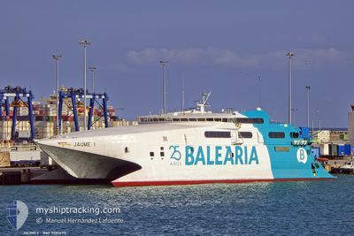
JAUME I
High speed craft
Current Trip
| Trip Time | 1 h, 10 mins |
|---|---|
| Trip Distance | 30.81 nm |
| AVG Speed | 18.3 Knots |
| MAX Speed | 18.3 Knots |
| Dybgang | 3.4 m |
| AVG Wind | 9.3 knots |
| MAX Wind | 17.8 knots |
| MIN Temp | 11.8°C / 53.24°F |
| MAX Temp | 15.2°C / 59.36°F |
| Position Modtaget | 1 m siden |
Current Position
| Longitude | -5.43924° |
|---|---|
| Latitude | 36.12924° |
| Status | Under way using engine |
| Fart | |
| Kurs | 54° |
| Område | Strait of Gibraltar |
| Station | T-AIS |
| Position Modtaget | 1 m siden |
Info
Information
The current position of JAUME I is in Strait of Gibraltar with coordinates 36.12924° / -5.43924° as reported on 2025-03-12 09:49 by AIS to our vessel tracker app. The vessel's current speed is 0 Knots and is currently inside the port of ALGECIRAS.
The vessel JAUME I (IMO: 9081693, MMSI: 209873000) is a High speed craft that was built in 1994 ( 31 år gamle ). It's sailing under the flag of [CY] Cyprus.
In this page you can find informations about the vessels current position, last detected port calls, and current voyage information. If the vessels is not in coverage by AIS you will find the latest position.
The current position of JAUME I is detected by our AIS receivers and we are not responsible for the reliability of the data. The last position was recorded while the vessel was in Coverage by the Ais receivers of our vessel tracking app.
The current draught of JAUME I as reported by AIS is 3.4 meters
Weather
| Temperature | 12°C / 53.6°F |
|---|---|
| Wind Speed | 5 knots |
| Direction | 270° W |
| Pressure | 1010.9 hPa |
| Humidity | 91.9 % |
| Cloud Coverage | 100 % |
Featured Company
Last Port Calls
| Port | Arrival | Departure | Time In Port |
|---|---|---|---|
| 2025-03-12 09:16 | |||
| 2025-03-12 08:05 | 2025-03-12 08:06 | 0 m | |
| 2025-03-11 22:10 | 2025-03-12 07:02 | 8 h | |
| 2025-03-11 20:52 | 2025-03-11 21:31 | 39 m | |
| 2025-03-11 19:13 | 2025-03-11 20:08 | 54 m | |
| 2025-03-11 17:51 | 2025-03-11 18:33 | 42 m | |
| 2025-03-11 13:35 | 2025-03-11 17:10 | 3 h | |
| 2025-03-11 11:29 | 2025-03-11 12:57 | 1 h | |
| 2025-03-11 09:21 | 2025-03-11 10:48 | 1 h | |
| 2025-03-11 07:52 | 2025-03-11 08:40 | 48 m |
Most Visited Ports (Last year)
| Port | Arrivals | |
|---|---|---|
| 360 | ||
| 202 | ||
| 141 | ||
| 2 | ||
| 1 |
Last Trips
| Origin | Departure | Destination | Arrival | Distance | |
|---|---|---|---|---|---|
| 2025-03-12 09:06 | 2025-03-12 10:16 | 30.81 nm | |||
| 2025-03-12 08:02 | 2025-03-12 09:05 | 32.34 nm | |||
| 2025-03-11 22:31 | 2025-03-11 23:10 | 15.62 nm | |||
| 2025-03-11 21:08 | 2025-03-11 21:52 | 16.72 nm | |||
| 2025-03-11 19:33 | 2025-03-11 20:13 | 15.71 nm | |||
| 2025-03-11 18:10 | 2025-03-11 18:51 | 16.70 nm | |||
| 2025-03-11 13:57 | 2025-03-11 14:35 | 15.17 nm | |||
| 2025-03-11 11:48 | 2025-03-11 12:29 | 16.85 nm | |||
| 2025-03-11 09:40 | 2025-03-11 10:21 | 16.03 nm | |||
| 2025-03-11 08:08 | 2025-03-11 08:52 | 17.04 nm |
Events
| Tid | Hændelsen | Detaljer | Position / Dest | Info |
|---|---|---|---|---|
| 2025-03-12 09:29 | STOP Sejllads |
36.12926 / -5.43917
[ES] ALGECIRAS
|
Fart: 0.2 kn Kurs: 56° |
|
| 2025-03-12 09:16 | Skibe i havn |
|
36.14820 / -5.43072
[ES] ALGECIRAS
|
Fart: 9 kn Kurs: 223° |
| 2025-03-12 09:10 | Ændre havområde | Spanish part of the Strait of Gibraltar Gibraltarian part of the Strait of Gibraltar |
36.14534 / -5.40609
Strait of Gibraltar
ALG CEU ALG
|
Fart: 14.1 kn Kurs: 311.4° |
| 2025-03-12 08:56 | Ændre havområde | Gibraltarian part of the Strait of Gibraltar Spanish part of the Strait of Gibraltar |
36.05372 / -5.35735
Strait of Gibraltar
ALG CEU ALG
|
Fart: 25.7 kn Kurs: 341.2° |
| 2025-03-12 08:55 | ETA er ændret | 2025/03/12 10:30 2025/03/12 09:30 |
36.05167 / -5.35656
ALG CEU ALG
|
Fart: 25.8 kn Kurs: 342.5° |
| 2025-03-12 08:53 | ETA er ændret | 2025/03/12 09:30 2025/03/11 23:30 |
36.03621 / -5.35105
ALG CEU ALG
|
Fart: 25.8 kn Kurs: 343.9° |
| 2025-03-12 08:38 | START Sejllads | 2.3 nm, North of CEUTA |
35.93204 / -5.31466
ALG CEU ALG
|
Fart: 25.2 kn Kurs: 338° |
| 2025-03-12 08:14 | ETA er ændret | 2025/03/11 23:30 2025/03/10 14:30 |
36.12925 / -5.43923
[ES] ALGECIRAS
|
Fart: Kurs: 52° |
| 2025-03-12 08:13 | STOP Sejllads |
36.12926 / -5.43926
[ES] ALGECIRAS
|
Fart: Kurs: 54° |
|
| 2025-03-12 08:13 | ETA er ændret | 2025/03/10 14:30 2025/03/08 23:30 |
36.14492 / -5.43114
[ES] ALGECIRAS
|
Fart: 8.9 kn Kurs: 16° |