

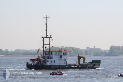
KOLLMAR
Law Enforcement

Current Trip
| Trip Time | 5 h, 13 mins |
|---|---|
| Trip Distance | 13.23 nm |
| AVG Speed | 4.4 Knots |
| MAX Speed | 9.1 Knots |
| Dybgang | 1.3 m |
| AVG Wind | 6.6 knots |
| MAX Wind | 8.8 knots |
| MIN Temp | 18.7°C / 65.66°F |
| MAX Temp | 21.6°C / 70.88°F |
| Position Modtaget | 1 m siden |
Current Position
| Longitude | 9.68668° |
|---|---|
| Latitude | 53.57162° |
| Status | Under way using engine |
| Fart | |
| Kurs | 280° |
| Område | North Sea |
| Station | T-AIS |
| Position Modtaget | 1 m siden |
Information
The current position of KOLLMAR is in North Sea with coordinates 53.57162° / 9.68668° as reported on 2025-05-25 06:27 by AIS to our vessel tracker app. The vessel's current speed is 0 Knots and is currently inside the port of WEDEL.
The vessel KOLLMAR (MMSI: 211430400) is a Law Enforcement It's sailing under the flag of [DE] Germany.
In this page you can find informations about the vessels current position, last detected port calls, and current voyage information. If the vessels is not in coverage by AIS you will find the latest position.
The current position of KOLLMAR is detected by our AIS receivers and we are not responsible for the reliability of the data. The last position was recorded while the vessel was in Coverage by the Ais receivers of our vessel tracking app.
The current draught of KOLLMAR as reported by AIS is 1.3 meters
Weather
| Temperature | 12.8°C / 55.04°F |
|---|---|
| Wind Speed | 9 knots |
| Direction | 214° SW |
| Pressure | 1006.6 hPa |
| Humidity | 98.2 % |
| Cloud Coverage | 100 % |


Featured Company
Last Port Calls
| Port | Arrival | Departure | Time In Port |
|---|---|---|---|
| 2025-05-20 15:44 | |||
| 2025-05-19 14:01 | 2025-05-20 10:31 | 20 h | |
| 2025-05-19 13:24 | 2025-05-19 13:42 | 18 m | |
| 2025-05-19 11:51 | 2025-05-19 13:03 | 1 h | |
| 2025-05-19 11:07 | 2025-05-19 11:27 | 19 m | |
| 2025-05-19 09:50 | 2025-05-19 10:17 | 27 m | |
| 2025-05-15 14:17 | 2025-05-19 08:15 | 3 d | |
| 2025-05-15 10:41 | 2025-05-15 14:03 | 3 h | |
| 2025-05-14 14:23 | 2025-05-15 06:51 | 16 h | |
| 2025-05-14 07:36 | 2025-05-14 07:39 | 3 m |
Most Visited Ports (Last year)
| Port | Arrivals | |
|---|---|---|
| 111 | ||
| 36 | ||
| 11 | ||
| 2 |
Last Trips
| Origin | Departure | Destination | Arrival | Distance | |
|---|---|---|---|---|---|
| 2025-05-20 10:31 | 2025-05-20 15:44 | 13.23 nm | |||
| 2025-05-19 13:42 | 2025-05-19 14:01 | 0.32 nm | |||
| 2025-05-19 13:03 | 2025-05-19 13:24 | 0.45 nm | |||
| 2025-05-19 11:27 | 2025-05-19 11:51 | 0.62 nm | |||
| 2025-05-19 10:17 | 2025-05-19 11:07 | 1.24 nm | |||
| 2025-05-19 08:15 | 2025-05-19 09:50 | 2.44 nm | |||
| 2025-05-15 14:03 | 2025-05-15 14:17 | 1.21 nm | |||
| 2025-05-15 06:51 | 2025-05-15 10:41 | 20.45 nm | |||
| 2025-05-14 07:39 | 2025-05-14 14:23 | 44.36 nm | |||
| 2025-05-14 07:27 | 2025-05-14 07:36 | 1.09 nm |
Events
| Tid | Hændelsen | Detaljer | Position / Dest | Info |
|---|---|---|---|---|
| 2025-05-20 13:44 | STOP Sejllads |
53.57165 / 9.68673
[DE] WEDEL
|
Fart: Kurs: 511° |
|
| 2025-05-20 13:44 | Skibe i havn |
|
53.57165 / 9.68673
[DE] WEDEL
|
Fart: 0.7 kn Kurs: 511° |
| 2025-05-20 13:31 | START Sejllads | 0.74 nm, West of WEDEL |
53.56546 / 9.67987
UNTERELBE
|
Fart: 3.1 kn Kurs: 84.5° |
| 2025-05-20 13:18 | STOP Sejllads | 1.08 nm, West of WEDEL |
53.56556 / 9.67004
UNTERELBE
|
Fart: 0.2 kn Kurs: 511° |
| 2025-05-20 12:28 | START Sejllads | 1.46 nm, South East of STADERSAND |
53.61060 / 9.56539
UNTERELBE
|
Fart: 4.4 kn Kurs: 82° |
| 2025-05-20 12:22 | STOP Sejllads | 1.38 nm, South East of STADERSAND |
53.61051 / 9.56223
UNTERELBE
|
Fart: 0.3 kn Kurs: 175° |
| 2025-05-20 12:02 | START Sejllads | 0.88 nm, South East of STADERSAND |
53.61774 / 9.55420
UNTERELBE
|
Fart: 3.1 kn Kurs: 195° |
| 2025-05-20 11:50 | STOP Sejllads | 0.81 nm, South East of STADERSAND |
53.61960 / 9.55384
UNTERELBE
|
Fart: 0.2 kn Kurs: 122° |
| 2025-05-20 11:42 | START Sejllads | 1.04 nm, South East of STADERSAND |
53.61730 / 9.55894
UNTERELBE
|
Fart: 4.2 kn Kurs: 303° |
| 2025-05-20 11:32 | STOP Sejllads | 1.35 nm, South East of STADERSAND |
53.61433 / 9.56610
UNTERELBE
|
Fart: 0.3 kn Kurs: 135° |