

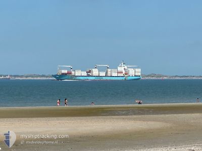
MAERSK NEWCASTLE
Container Ship

Current Trip
| Time Travelled | 7 days |
|---|---|
| Remaining Time | --- |
| Distance Travelled | 282.58 nm |
| Remaining Distance | --- |
| AVG Speed | 6.3 Knots |
| MAX Speed | 13.5 Knots |
| AVG Wind | 18 knots |
| MAX Wind | 29.9 knots |
| MIN Temp | 11.1°C / 51.98°F |
| MAX Temp | 14.5°C / 58.1°F |
| Dybgang | 7.4 m |
| Position Modtaget | 1 m siden |
Current Position
| Longitude | 11.65195° |
|---|---|
| Latitude | 57.54004° |
| Status | At anchor |
| Fart | |
| Kurs | 279° |
| Område | Kattegat |
| Station | T-AIS |
| Position Modtaget | 1 m siden |
Information
The current position of MAERSK NEWCASTLE is in Kattegat with coordinates 57.54004° / 11.65195° as reported on 2025-06-11 21:22 by AIS to our vessel tracker app. The vessel's current speed is 0 Knots
The vessel MAERSK NEWCASTLE (IMO: 9215878, MMSI: 563460000) is a Container Ship that was built in 2001 ( 24 år gamle ). It's sailing under the flag of [SG] Singapore.
In this page you can find informations about the vessels current position, last detected port calls, and current voyage information. If the vessels is not in coverage by AIS you will find the latest position.
The current position of MAERSK NEWCASTLE is detected by our AIS receivers and we are not responsible for the reliability of the data. The last position was recorded while the vessel was in Coverage by the Ais receivers of our vessel tracking app.
The current draught of MAERSK NEWCASTLE as reported by AIS is 7.4 meters
Weather
| Temperature | 13.5°C / 56.3°F |
|---|---|
| Wind Speed | 12 knots |
| Direction | 281° W |
| Pressure | 1019.9 hPa |
| Humidity | 79.6 % |
| Cloud Coverage | 6 % |


Featured Company
Last Port Calls
| Port | Arrival | Departure | Time In Port |
|---|---|---|---|
| 2025-06-04 05:49 | 2025-06-04 14:23 | 8 h | |
| 2025-06-01 16:44 | 2025-06-03 05:11 | 1 d | |
| 2025-05-29 23:49 | 2025-05-31 09:29 | 1 d | |
| 2025-05-25 19:07 | 2025-05-26 22:13 | 1 d | |
| 2025-05-22 19:19 | 2025-05-24 05:30 | 1 d | |
| 2025-05-19 04:35 | 2025-05-20 22:56 | 1 d | |
| 2025-05-16 09:12 | 2025-05-17 20:00 | 1 d | |
| 2025-05-12 21:41 | 2025-05-13 22:45 | 1 d | |
| 2025-05-09 09:57 | 2025-05-11 14:36 | 2 d | |
| 2025-05-06 21:32 | 2025-05-07 22:20 | 1 d |
Most Visited Ports (Last year)
| Port | Arrivals | |
|---|---|---|
| 14 | ||
| 9 | ||
| 6 | ||
| 6 | ||
| 6 | ||
| 5 |
Last Trips
| Origin | Departure | Destination | Arrival | Distance | |
|---|---|---|---|---|---|
| 2025-06-03 05:11 | 2025-06-04 05:49 | 389.98 nm | |||
| 2025-05-31 09:29 | 2025-06-01 16:44 | 387.25 nm | |||
| 2025-05-26 22:13 | 2025-05-29 23:49 | 400.43 nm | |||
| 2025-05-24 05:30 | 2025-05-25 19:07 | 389.77 nm | |||
| 2025-05-20 22:56 | 2025-05-22 19:19 | 397.85 nm | |||
| 2025-05-17 20:00 | 2025-05-19 04:35 | 383.93 nm | |||
| 2025-05-13 22:45 | 2025-05-16 09:12 | 391.88 nm | |||
| 2025-05-11 14:36 | 2025-05-12 21:41 | 385.50 nm | |||
| 2025-05-07 22:20 | 2025-05-09 09:57 | 380.90 nm | |||
| 2025-05-05 11:23 | 2025-05-06 21:32 | 383.36 nm |
Events
| Tid | Hændelsen | Detaljer | Position / Dest | Info |
|---|---|---|---|---|
| 2025-06-10 08:19 | Destination er ændret | SEGOT ANCH-SEGOT SEGOT-SEGOT ANCH |
57.54243 / 11.64677
SEGOT ANCH-SEGOT
|
Fart: Kurs: 142° |
| 2025-06-10 07:28 | Status er ændret | At anchor Under way using engine |
57.54024 / 11.65029
SEGOT-SEGOT ANCH
|
Fart: 0.7 kn Kurs: 281° |
| 2025-06-10 07:08 | STOP Sejllads | 4.69 nm, South West of VRANGO |
57.54160 / 11.64628
SEGOT-SEGOT ANCH
|
Fart: 0.3 kn Kurs: 55° |
| 2025-06-09 16:30 | START Sejllads | 10.01 nm, West of RORO |
57.81737 / 11.32132
SEGOT-SEGOT ANCH
|
Fart: 3.1 kn Kurs: 184° |
| 2025-06-09 14:04 | STOP Sejllads | 15.66 nm, South West of STANSVIKS |
57.83300 / 11.12217
SEGOT-SEGOT ANCH
|
Fart: 0.3 kn Kurs: 242° |
| 2025-06-08 16:24 | START Sejllads | 8.37 nm, West of RORO |
57.77266 / 11.36011
SEGOT-SEGOT ANCH
|
Fart: 3.1 kn Kurs: 190° |
| 2025-06-08 10:41 | STOP Sejllads | 12.85 nm, West of RORO |
57.80530 / 11.22560
SEGOT-SEGOT ANCH
|
Fart: 0.3 kn Kurs: 159° |
| 2025-06-08 04:07 | ETA er ændret | 2025/06/12 22:00 2025/06/04 14:00 |
57.80942 / 11.35589
SEGOT-SEGOT ANCH
|
Fart: 1 kn Kurs: 147° |
| 2025-06-06 17:10 | START Sejllads | 3.4 nm, West of VRANGO |
57.55953 / 11.67645
SEGOT-SEGOT ANCH
|
Fart: 3.3 kn Kurs: 273° |
| 2025-06-06 16:56 | Status er ændret | Under way using engine At anchor |
57.55106 / 11.67476
SEGOT-SEGOT ANCH
|
Fart: 1.4 kn Kurs: 306° |