
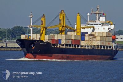
NEGAR
General Cargo
Current Trip
KHOWR MUSA ANCHORAGE
| Time Travelled | 1 day |
|---|---|
| Remaining Time | --- |
| Distance Travelled | 417.35 nm |
| Remaining Distance | --- |
| AVG Speed | 12.9 Knots |
| MAX Speed | 15.7 Knots |
| AVG Wind | 6.8 knots |
| MAX Wind | 21 knots |
| MIN Temp | 19.5°C / 67.1°F |
| MAX Temp | 26.5°C / 79.7°F |
| Dybgang | 6.5 m |
| Position Modtaget | 4 h, 4 m siden |
Current Position
| Longitude | 50.88385° |
|---|---|
| Latitude | 28.14421° |
| Status | Under way using engine |
| Fart | 13.1 Knots |
| Kurs | 321.3° |
| Område | Persian Gulf |
| Station | T-AIS |
| Position Modtaget | 4 h, 4 m siden |
Info
Information
The current position of NEGAR is in Persian Gulf with coordinates 28.14421° / 50.88385° as reported on 2025-03-09 09:42 by AIS to our vessel tracker app. The vessel's current speed is 13.1 Knots
The vessel NEGAR (IMO: 9165839, MMSI: 422036900) is a General Cargo that was built in 1999 ( 26 år gamle ). It's sailing under the flag of [IR] Iran.
In this page you can find informations about the vessels current position, last detected port calls, and current voyage information. If the vessels is not in coverage by AIS you will find the latest position.
The current position of NEGAR is detected by our AIS receivers and we are not responsible for the reliability of the data. The last position was recorded while the vessel was in Coverage by the Ais receivers of our vessel tracking app.
The current draught of NEGAR as reported by AIS is 6.5 meters
Weather
| Temperature | 19.7°C / 67.46°F |
|---|---|
| Wind Speed | 8 knots |
| Direction | 317° NW |
| Pressure | 1012.6 hPa |
| Humidity | 74.7 % |
| Cloud Coverage | --- |
Featured Company
Last Port Calls
| Port | Arrival | Departure | Time In Port |
|---|---|---|---|
| 2025-03-05 20:25 | 2025-03-07 16:24 | 1 d | |
| 2025-02-15 00:48 | 2025-02-16 21:34 | 1 d | |
| 2025-01-23 02:44 | 2025-01-24 11:16 | 1 d | |
| 2025-01-08 23:21 | 2025-01-10 02:44 | 1 d |
Most Visited Ports (Last year)
| Port | Arrivals | |
|---|---|---|
| 5 | ||
| 4 | ||
| 2 | ||
| 2 | ||
| 1 | ||
| 1 |
Last Trips
| Origin | Departure | Destination | Arrival | Distance | |
|---|---|---|---|---|---|
| 2025-02-17 00:34 | 2025-03-05 23:55 | 3014.83 nm | |||
| 2025-01-24 14:16 | 2025-02-15 03:48 | 268.70 nm | |||
| 2025-01-10 06:14 | 2025-01-23 05:44 | 2711.11 nm | |||
| 2024-12-31 20:44 | 2025-01-09 02:51 | 572.32 nm |
Events
| Tid | Hændelsen | Detaljer | Position / Dest | Info |
|---|---|---|---|---|
| 2025-03-09 09:44 | Status er ændret | Default Under way using engine |
28.14990 / 50.87868
KHOWR MUSA ANCHORAGE
|
Fart: 13.1 kn Kurs: 321.3° |
| 2025-03-09 09:42 | Status er ændret | Under way using engine Default |
28.14421 / 50.88385
KHOWR MUSA ANCHORAGE
|
Fart: 13.1 kn Kurs: 322° |
| 2025-03-09 09:42 | Indenfor Dækning |
28.14421 / 50.88385
Persian Gulf
|
Fart: 13.1 kn Kurs: 321.3° |
|
| 2025-03-09 09:42 | Udenfor Dækning |
28.14421 / 50.88385
Persian Gulf
|
Fart: 13.1 kn Kurs: 321.3° |
|
| 2025-03-08 12:38 | Status er ændret | Default Under way using engine |
26.34910 / 55.42585
KHOWR MUSA ANCHORAGE
|
Fart: 12.9 kn Kurs: 257.8° |
| 2025-03-08 12:38 | Status er ændret | Under way using engine Default |
26.34963 / 55.42843
KHOWR MUSA ANCHORAGE
|
Fart: 13 kn Kurs: 258° |
| 2025-03-08 12:38 | Udenfor Dækning |
26.34963 / 55.42843
Persian Gulf
|
Fart: 12.9 kn Kurs: 257.8° |
|
| 2025-03-08 12:33 | Status er ændret | Default Under way using engine |
26.35332 / 55.44742
KHOWR MUSA ANCHORAGE
|
Fart: 12.9 kn Kurs: 256.1° |
| 2025-03-08 12:17 | Ændre havområde | Iranian part of the Persian Gulf Tanzanian part of the Indian Ocean |
26.36588 / 55.50886
Persian Gulf
|
Fart: 12.7 kn Kurs: 256.8° |
| 2025-03-08 12:17 | Status er ændret | Under way using engine Default |
26.36614 / 55.51007
KHOWR MUSA ANCHORAGE
|
Fart: 12.8 kn Kurs: 259° |