
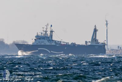
NORDKAP
Factory Trawler
Current Trip
| Time Travelled | 1 day |
|---|---|
| Remaining Time | --- |
| Distance Travelled | 105.82 nm |
| Remaining Distance | --- |
| AVG Speed | 9.9 Knots |
| MAX Speed | 11.8 Knots |
| AVG Wind | 16.2 knots |
| MAX Wind | 18.9 knots |
| MIN Temp | -3.5°C / 25.7°F |
| MAX Temp | -1.2°C / 29.84°F |
| Dybgang | 6.8 m |
| Position Modtaget | 22 h, 31 m siden |
Current Position
| Longitude | 33.53798° |
|---|---|
| Latitude | 70.90428° |
| Status | Under way using engine |
| Fart | 8.9 Knots |
| Kurs | 31.7° |
| Område | Barentsz Sea |
| Station | T-AIS |
| Position Modtaget | 22 h, 31 m siden |
Info
Information
The current position of NORDKAP is in Barentsz Sea with coordinates 70.90428° / 33.53798° as reported on 2025-02-13 20:07 by AIS to our vessel tracker app. The vessel's current speed is 8.9 Knots and is heading at the port of MURMANSK. The estimated time of arrival as calculated by MyShipTracking vessel tracking app is 2025-02-14 00:00 LT
The vessel NORDKAP (IMO: 8913241, MMSI: 273316960) is a Factory Trawler that was built in 1990 ( 35 år gamle ). It's sailing under the flag of [RU] Russia.
In this page you can find informations about the vessels current position, last detected port calls, and current voyage information. If the vessels is not in coverage by AIS you will find the latest position.
The current position of NORDKAP is detected by our AIS receivers and we are not responsible for the reliability of the data. The last position was recorded while the vessel was in Coverage by the Ais receivers of our vessel tracking app.
The current draught of NORDKAP as reported by AIS is 6.8 meters
Weather
| Temperature | -2.6°C / 27.32°F |
|---|---|
| Wind Speed | 17 knots |
| Direction | 19° NNE |
| Pressure | 1019.1 hPa |
| Humidity | 59.9 % |
| Cloud Coverage | 100 % |
Featured Company
Events
| Tid | Hændelsen | Detaljer | Position / Dest | Info |
|---|---|---|---|---|
| 2025-02-13 20:07 | Udenfor Dækning |
70.90428 / 33.53798
Barentsz Sea
BARENTS SEA
|
Fart: 8.9 kn Kurs: 31.7° |
|
| 2025-02-13 13:16 | Ændre havområde | Russian part of the Barentsz Sea Norwegian part of the Barentsz Sea |
70.14504 / 31.60443
Barentsz Sea
BARENTS SEA
|
Fart: 10.9 kn Kurs: 82° |
| 2025-02-13 09:28 | ETA er ændret | 2025/02/14 00:00 2025/02/12 09:00 |
69.77070 / 30.08911
BARENTS SEA
|
Fart: 11.8 kn Kurs: 11.3° |
| 2025-02-13 09:23 | Status er ændret | Under way using engine Moored |
69.75796 / 30.08139
BARENTS SEA
|
Fart: 11.7 kn Kurs: 11.6° |
| 2025-02-13 09:21 | Destination er ændret | BARENTS SEA KIRKENES |
69.75116 / 30.07717
BARENTS SEA
|
Fart: 11.7 kn Kurs: 11.6° |
| 2025-02-13 09:12 | START Sejllads | 0.39 nm, East of KIRKENES |
69.73207 / 30.07807
KIRKENES
|
Fart: 5.2 kn Kurs: 339° |
| 2025-02-13 09:12 | Afsejlet fra sidste havn |
|
69.73207 / 30.07807
KIRKENES
|
Fart: 3.2 kn Kurs: 48° |
| 2025-02-12 13:35 | Status er ændret | Moored Under way using engine |
69.72954 / 30.07737
[NO] KIRKENES
|
Fart: Kurs: 72° |
| 2025-02-12 13:25 | STOP Sejllads |
69.72951 / 30.07715
[NO] KIRKENES
|
Fart: Kurs: 72° |
|
| 2025-02-12 13:19 | Skibe i havn |
|
69.72982 / 30.06973
[NO] KIRKENES
|
Fart: 5.3 kn Kurs: 159.7° |