
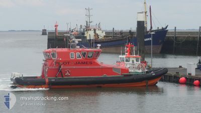
JAMES
Pilot Vessel
Current Trip
| Time Travelled | 1 h, 50 mins |
|---|---|
| Remaining Time | --- |
| Distance Travelled | 0.44 nm |
| Remaining Distance | --- |
| AVG Speed | --- |
| MAX Speed | --- |
| AVG Wind | 13 knots |
| MAX Wind | 13 knots |
| MIN Temp | 2.7°C / 36.86°F |
| MAX Temp | 2.7°C / 36.86°F |
| Dybgang | 0.9 m |
| Position Modtaget | 1 h, 48 m siden |
Current Position
| Longitude | 10.03734° |
|---|---|
| Latitude | 54.67046° |
| Status | Under way using engine |
| Fart | 21 Knots |
| Kurs | 298.1° |
| Område | Baltic Sea |
| Station | T-AIS |
| Position Modtaget | 1 h, 48 m siden |
Info
Information
The current position of JAMES is in Baltic Sea with coordinates 54.67046° / 10.03734° as reported on 2025-02-09 11:06 by AIS to our vessel tracker app. The vessel's current speed is 21 Knots
The vessel JAMES (IMO: 9335599, MMSI: 232029828) is a Pilot Vessel It's sailing under the flag of [GB] United Kingdom.
In this page you can find informations about the vessels current position, last detected port calls, and current voyage information. If the vessels is not in coverage by AIS you will find the latest position.
The current position of JAMES is detected by our AIS receivers and we are not responsible for the reliability of the data. The last position was recorded while the vessel was in Coverage by the Ais receivers of our vessel tracking app.
The current draught of JAMES as reported by AIS is 0.9 meters
Weather
| Temperature | 2.7°C / 36.86°F |
|---|---|
| Wind Speed | 14 knots |
| Direction | 59° ENE |
| Pressure | 1034.7 hPa |
| Humidity | 84.8 % |
| Cloud Coverage | 100 % |
Featured Company
Last Port Calls
| Port | Arrival | Departure | Time In Port |
|---|---|---|---|
| 2025-02-09 11:04 | 2025-02-09 11:05 | 0 m | |
| 2025-02-08 20:15 | 2025-02-09 06:56 | 10 h | |
| 2025-02-08 14:09 | 2025-02-08 15:38 | 1 h | |
| 2025-02-07 20:48 | 2025-02-08 11:48 | 14 h | |
| 2025-02-07 09:01 | 2025-02-07 10:06 | 1 h | |
| 2025-02-05 14:28 | 2025-02-07 06:17 | 1 d | |
| 2025-02-05 14:17 |
Last Trips
| Origin | Departure | Destination | Arrival | Distance | |
|---|---|---|---|---|---|
| 2025-02-08 16:38 | 2025-02-08 21:15 | 33.12 nm | |||
| 2025-02-08 12:48 | 2025-02-08 15:09 | 33.74 nm | |||
| 2025-02-07 11:06 | 2025-02-07 21:48 | 88.83 nm | |||
| 2025-02-07 07:17 | 2025-02-07 10:01 | 25.23 nm | |||
| 2025-02-05 15:17 | 2025-02-05 15:28 | 1.46 nm |
Events
| Tid | Hændelsen | Detaljer | Position / Dest | Info |
|---|---|---|---|---|
| 2025-02-09 11:06 | Udenfor Dækning |
54.67046 / 10.03734
Baltic Sea
KAPPELN
|
Fart: 21 kn Kurs: 298.1° |
|
| 2025-02-09 11:05 | Afsejlet fra sidste havn |
|
54.66459 / 10.04298
KAPPELN
|
Fart: 23.1 kn Kurs: 338° |
| 2025-02-09 11:04 | Skibe i havn |
|
54.66190 / 10.04441
[DE] OLPENITZ
|
Fart: 21.5 kn Kurs: 347° |
| 2025-02-09 10:28 | Ændre havområde | German part of the Baltic Sea German part of the North Sea |
54.47722 / 10.20201
Baltic Sea
KAPPELN
|
Fart: 22.4 kn Kurs: 339.2° |
| 2025-02-09 09:59 | START Sejllads | 1.28 nm, South West of STICKENHΟRN SPORT |
54.36539 / 10.14705
KAPPELN
|
Fart: 7.9 kn Kurs: 101.9° |
| 2025-02-09 09:17 | STOP Sejllads | 1.34 nm, South West of STICKENHΟRN SPORT |
54.36568 / 10.14355
KAPPELN
|
Fart: 0.3 kn Kurs: 103° |
| 2025-02-09 06:56 | Afsejlet fra sidste havn |
|
54.31620 / 9.71181
KAPPELN
|
Fart: 7.3 kn Kurs: 29° |
| 2025-02-09 06:54 | Destination er ændret | KAPPELN RENDSBURG |
54.31283 / 9.70498
[DE] RENDSBURG
|
Fart: 7.3 kn Kurs: 61° |
| 2025-02-09 06:54 | ETA er ændret | 2025/02/09 13:00 2025/02/08 18:00 |
54.31283 / 9.70498
[DE] RENDSBURG
|
Fart: 7.3 kn Kurs: 61° |
| 2025-02-09 06:43 | START Sejllads |
54.30779 / 9.66838
[DE] RENDSBURG
|
Fart: 6.8 kn Kurs: 61° |