

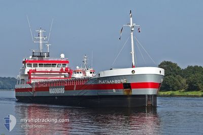
PLATAANBORG
General Cargo

Current Trip
| Time Travelled | 1 day |
|---|---|
| Remaining Time | 16 h, 30 mins |
| Distance Travelled | 259.80 nm |
| Remaining Distance | 183.50 nm |
| AVG Speed | 8.8 Knots |
| MAX Speed | 12.2 Knots |
| AVG Wind | 14.6 knots |
| MAX Wind | 21.8 knots |
| MIN Temp | 8.2°C / 46.76°F |
| MAX Temp | 13°C / 55.4°F |
| Dybgang | 5.8 m |
| Position Modtaget | 2 h, 43 m siden |
Current Position
| Longitude | -5.72123° |
|---|---|
| Latitude | 55.06000° |
| Status | Under way using engine |
| Fart | 10.7 Knots |
| Kurs | 332.8° |
| Område | Inner Seas off the West Coast of Scotland |
| Station | T-AIS |
| Position Modtaget | 2 h, 43 m siden |
Information
The current position of PLATAANBORG is in Inner Seas off the West Coast of Scotland with coordinates 55.06000° / -5.72123° as reported on 2025-06-07 22:49 by AIS to our vessel tracker app. The vessel's current speed is 10.7 Knots and is heading at the port of EASTHAM. The estimated time of arrival as calculated by MyShipTracking vessel tracking app is 2025-06-08 19:03 LT
The vessel PLATAANBORG (IMO: 9489522, MMSI: 245169000) is a General Cargo that was built in 2009 ( 16 år gamle ). It's sailing under the flag of [NL] Netherlands.
In this page you can find informations about the vessels current position, last detected port calls, and current voyage information. If the vessels is not in coverage by AIS you will find the latest position.
The current position of PLATAANBORG is detected by our AIS receivers and we are not responsible for the reliability of the data. The last position was recorded while the vessel was in Coverage by the Ais receivers of our vessel tracking app.
The current draught of PLATAANBORG as reported by AIS is 5.8 meters
Weather
| Temperature | 10.1°C / 50.18°F |
|---|---|
| Wind Speed | 12 knots |
| Direction | 295° WNW |
| Pressure | 1010.7 hPa |
| Humidity | 79.9 % |
| Cloud Coverage | 98 % |


Featured Company
Last Port Calls
| Port | Arrival | Departure | Time In Port |
|---|---|---|---|
| 2025-06-05 21:15 | 2025-06-06 19:19 | 22 h | |
| 2025-05-29 07:58 | 2025-05-30 22:01 | 1 d | |
| 2025-05-18 08:46 | 2025-05-19 21:30 | 1 d | |
| 2025-05-14 23:20 | 2025-05-15 18:28 | 19 h | |
| 2025-05-13 15:35 | 2025-05-14 13:12 | 21 h | |
| 2025-05-05 18:22 | 2025-05-07 16:59 | 1 d | |
| 2025-04-30 08:44 | 2025-05-01 15:17 | 1 d | |
| 2025-04-29 21:09 | 2025-04-29 21:28 | 18 m | |
| 2025-04-28 21:47 | 2025-04-29 20:06 | 22 h | |
| 2025-04-28 17:41 | 2025-04-28 21:18 | 3 h |
Last Trips
| Origin | Departure | Destination | Arrival | Distance | |
|---|---|---|---|---|---|
| 2025-05-30 22:01 | 2025-06-05 21:15 | 1294.25 nm | |||
| 2025-05-19 21:30 | 2025-05-29 07:58 | 1454.76 nm | |||
| 2025-05-15 18:28 | 2025-05-18 08:46 | 515.74 nm | |||
| 2025-05-14 13:12 | 2025-05-14 23:20 | 91.91 nm | |||
| 2025-05-07 16:59 | 2025-05-13 15:35 | 1025.69 nm | |||
| 2025-05-01 15:17 | 2025-05-05 18:22 | 903.56 nm | |||
| 2025-04-29 21:28 | 2025-04-30 08:44 | 63.00 nm | |||
| 2025-04-29 20:06 | 2025-04-29 21:09 | 8.60 nm | |||
| 2025-04-28 21:18 | 2025-04-28 21:47 | 2.55 nm | |||
| 2025-04-26 02:06 | 2025-04-28 17:41 | 606.50 nm |
Events
| Tid | Hændelsen | Detaljer | Position / Dest | Info |
|---|---|---|---|---|
| 2025-06-07 22:57 | Status er ændret | Default Under way using engine |
55.08072 / -5.73898
RAYNES JETTY
|
Fart: 10.7 kn Kurs: 332.8° |
| 2025-06-07 22:49 | Udenfor Dækning |
55.06000 / -5.72123
Inner Seas off the West Coast of Scotland
RAYNES JETTY
|
Fart: 10.7 kn Kurs: 332.8° |
|
| 2025-06-07 22:48 | Status er ændret | Under way using engine Default |
55.05820 / -5.71961
RAYNES JETTY
|
Fart: 10.6 kn Kurs: 331° |
| 2025-06-07 22:45 | Status er ændret | Default Under way using engine |
55.04903 / -5.71132
RAYNES JETTY
|
Fart: 10.3 kn Kurs: 332.2° |
| 2025-06-07 18:22 | Ændre havområde | United Kingdom part of the Inner Seas off the West Coast of Scotland United Kingdom part of the Irish Sea and St. George's Channel |
54.48174 / -5.23754
Inner Seas off the West Coast of Scotland
RAYNES JETTY
|
Fart: 7.8 kn Kurs: 333.6° |
| 2025-06-07 15:53 | Dybgangen er ændret | 5.8 2.9 |
54.16896 / -4.97629
RAYNES JETTY
|
Fart: 9.1 kn Kurs: 334.8° |
| 2025-06-07 15:53 | ETA er ændret | 2025/06/15 06:00 2025/06/07 03:30 |
54.16896 / -4.97629
RAYNES JETTY
|
Fart: 9.1 kn Kurs: 334.8° |
| 2025-06-07 15:37 | Status er ændret | Under way using engine Default |
54.13242 / -4.94723
RAYNES JETTY
|
Fart: 9.1 kn Kurs: 337° |
| 2025-06-07 15:37 | Status er ændret | Default Under way using engine |
54.13050 / -4.94572
RAYNES JETTY
|
Fart: 9 kn Kurs: 334.6° |
| 2025-06-07 15:29 | Status er ændret | Under way using engine Default |
54.11299 / -4.93189
RAYNES JETTY
|
Fart: 9.3 kn Kurs: 336° |