
PRIMROSE ATLANTIC
Cargo
Current Trip
| Time Travelled | 5 days |
|---|---|
| Remaining Time | --- |
| Distance Travelled | 1662.80 nm |
| Remaining Distance | --- |
| AVG Speed | 12.3 Knots |
| MAX Speed | 15.1 Knots |
| AVG Wind | 14.3 knots |
| MAX Wind | 25.9 knots |
| MIN Temp | 4.6°C / 40.28°F |
| MAX Temp | 22.9°C / 73.22°F |
| Dybgang | 7.3 m |
| Position Modtaget | 5 d siden |
Current Position
| Longitude | 134.97430° |
|---|---|
| Latitude | 33.64752° |
| Status | Under way using engine |
| Fart | 12.6 Knots |
| Kurs | 181.6° |
| Område | Philippine Sea |
| Station | T-AIS |
| Position Modtaget | 5 d siden |
Info
Information
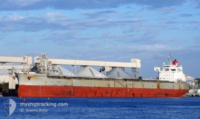
The current position of PRIMROSE ATLANTIC is in Philippine Sea with coordinates 33.64752° / 134.97430° as reported on 2025-02-09 09:58 by AIS to our vessel tracker app. The vessel's current speed is 12.6 Knots and is heading at the port of PORTLAND. The estimated time of arrival as calculated by MyShipTracking vessel tracking app is 2025-02-27 12:00 LT
The vessel PRIMROSE ATLANTIC (IMO: 9544097, MMSI: 374907000) is a Cargo It's sailing under the flag of [PA] Panama.
In this page you can find informations about the vessels current position, last detected port calls, and current voyage information. If the vessels is not in coverage by AIS you will find the latest position.
The current position of PRIMROSE ATLANTIC is detected by our AIS receivers and we are not responsible for the reliability of the data. The last position was recorded while the vessel was in Coverage by the Ais receivers of our vessel tracking app.
The current draught of PRIMROSE ATLANTIC as reported by AIS is 7.3 meters
Weather
| Temperature | 22.6°C / 72.68°F |
|---|---|
| Wind Speed | 18 knots |
| Direction | 277° W |
| Pressure | 1008.7 hPa |
| Humidity | 77.7 % |
| Cloud Coverage | --- |
Featured Company
Last Port Calls
| Port | Arrival | Departure | Time In Port |
|---|---|---|---|
| 2025-02-02 10:58 | 2025-02-09 03:16 | 6 d | |
| 2025-01-14 07:30 | 2025-01-15 19:24 | 1 d | |
| 2024-12-25 12:37 | 2024-12-26 23:27 | 1 d | |
| 2024-12-05 02:49 |
Most Visited Ports (Last year)
| Port | Arrivals | |
|---|---|---|
| 4 | ||
| 2 | ||
| 2 | ||
| 2 | ||
| 1 | ||
| 1 |
Last Trips
| Origin | Departure | Destination | Arrival | Distance | |
|---|---|---|---|---|---|
| 2025-01-16 05:24 | 2025-02-02 19:58 | 4036.20 nm | |||
| 2024-12-27 10:27 | 2025-01-14 17:30 | 735.88 nm | |||
| 2024-12-05 11:49 | 2024-12-25 23:37 | 4728.82 nm |
Events
| Tid | Hændelsen | Detaljer | Position / Dest | Info |
|---|---|---|---|---|
| 2025-02-09 10:05 | Status er ændret | Default Under way using engine |
33.62343 / 134.97407
USPDX
|
Fart: 12.6 kn Kurs: 181.6° |
| 2025-02-09 09:58 | Status er ændret | Under way using engine Default |
33.64752 / 134.97430
USPDX
|
Fart: 12.7 kn Kurs: 183° |
| 2025-02-09 09:58 | Udenfor Dækning |
33.64752 / 134.97430
Philippine Sea
USPDX
|
Fart: 12.6 kn Kurs: 181.6° |
|
| 2025-02-09 09:34 | Status er ændret | Default Under way using engine |
33.73096 / 134.97929
USPDX
|
Fart: 13 kn Kurs: 181.3° |
| 2025-02-09 09:26 | Status er ændret | Under way using engine Default |
33.76056 / 134.98027
USPDX
|
Fart: 12.9 kn Kurs: 181° |
| 2025-02-09 09:21 | Status er ændret | Default Under way using engine |
33.77978 / 134.98090
USPDX
|
Fart: 12.9 kn Kurs: 180.7° |
| 2025-02-09 09:21 | Status er ændret | Under way using engine Default |
33.78038 / 134.98090
USPDX
|
Fart: 12.7 kn Kurs: 175° |
| 2025-02-09 09:09 | Status er ændret | Default Under way using engine |
33.82144 / 134.97662
USPDX
|
Fart: 12.5 kn Kurs: 175.8° |
| 2025-02-09 08:53 | Status er ændret | Under way using engine Default |
33.87869 / 134.97233
USPDX
|
Fart: 12.5 kn Kurs: 177° |
| 2025-02-09 08:39 | Status er ændret | Default Under way using engine |
33.92657 / 134.96954
USPDX
|
Fart: 12.5 kn Kurs: 176.6° |