
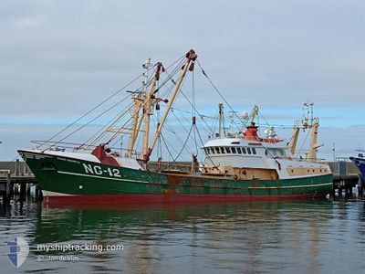
PRINS MAURITS
Fishing
Current Trip
| Trip Time | 7 h, 50 mins |
|---|---|
| Trip Distance | 81.51 nm |
| AVG Speed | 10.1 Knots |
| MAX Speed | 12.8 Knots |
| Dybgang | 4.3 m |
| AVG Wind | 15.2 knots |
| MAX Wind | 17 knots |
| MIN Temp | 3.2°C / 37.76°F |
| MAX Temp | 4.4°C / 39.92°F |
| Position Modtaget | 1 m siden |
Current Position
| Longitude | 4.58927° |
|---|---|
| Latitude | 52.45956° |
| Status | Under way using engine |
| Fart | |
| Kurs | 299° |
| Område | North Sea |
| Station | T-AIS |
| Position Modtaget | 1 m siden |
Info
Information
The current position of PRINS MAURITS is in North Sea with coordinates 52.45956° / 4.58927° as reported on 2026-01-08 10:34 by AIS to our vessel tracker app. The vessel's current speed is 0 Knots and is currently inside the port of IJMUIDEN.
The vessel PRINS MAURITS (IMO: 1918608, MMSI: 211315540) is a Fishing It's sailing under the flag of [DE] Germany.
In this page you can find informations about the vessels current position, last detected port calls, and current voyage information. If the vessels is not in coverage by AIS you will find the latest position.
The current position of PRINS MAURITS is detected by our AIS receivers and we are not responsible for the reliability of the data. The last position was recorded while the vessel was in Coverage by the Ais receivers of our vessel tracking app.
The current draught of PRINS MAURITS as reported by AIS is 4.3 meters
Weather
| Temperature | 5.5°C / 41.9°F |
|---|---|
| Wind Speed | 13 knots |
| Direction | 247° WSW |
| Pressure | 1004.4 hPa |
| Humidity | 78.5 % |
| Cloud Coverage | 100 % |
Featured Company
Last Port Calls
| Port | Arrival | Departure | Time In Port |
|---|---|---|---|
| 2026-01-05 12:57 | |||
| 2025-12-24 13:11 | 2026-01-05 05:07 | 11 d | |
| 2025-12-19 00:29 | 2025-12-22 02:04 | 3 d | |
| 2025-12-12 02:08 | 2025-12-15 02:06 | 2 d | |
| 2025-12-05 20:52 | 2025-12-08 02:20 | 2 d | |
| 2025-11-28 00:21 | 2025-12-02 00:23 | 4 d | |
| 2025-11-21 21:05 | 2025-11-24 02:02 | 2 d | |
| 2025-11-14 02:27 | 2025-11-17 20:58 | 3 d | |
| 2025-11-07 02:32 | 2025-11-10 02:03 | 2 d | |
| 2025-11-03 02:01 |
Last Trips
| Origin | Departure | Destination | Arrival | Distance | |
|---|---|---|---|---|---|
| 2026-01-05 05:07 | 2026-01-05 12:57 | 81.51 nm | |||
| 2025-12-22 02:04 | 2025-12-24 13:11 | 71.14 nm | |||
| 2025-12-15 02:06 | 2025-12-19 00:29 | 110.88 nm | |||
| 2025-12-08 02:20 | 2025-12-12 02:08 | 82.44 nm | |||
| 2025-12-02 00:23 | 2025-12-05 20:52 | 84.20 nm | |||
| 2025-11-24 02:02 | 2025-11-28 00:21 | 79.99 nm | |||
| 2025-11-17 20:58 | 2025-11-21 21:05 | 74.29 nm | |||
| 2025-11-10 02:03 | 2025-11-14 02:27 | 83.70 nm | |||
| 2025-11-03 02:01 | 2025-11-07 02:32 | 173.88 nm |
Events
| Tid | Hændelsen | Detaljer | Position / Dest | Info |
|---|---|---|---|---|
| 2026-01-08 07:41 | STOP Sejllads |
52.46000 / 4.58830
[NL] IJMUIDEN
|
Fart: 0.3 kn Kurs: 106° |
|
| 2026-01-08 07:32 | START Sejllads |
52.46066 / 4.57987
[NL] IJMUIDEN
|
Fart: 4.1 kn Kurs: 4° |
|
| 2026-01-05 11:58 | STOP Sejllads |
52.45884 / 4.57935
[NL] IJMUIDEN
|
Fart: 0.2 kn Kurs: 230° |
|
| 2026-01-05 11:57 | Skibe i havn |
|
52.45885 / 4.57935
[NL] IJMUIDEN
|
Fart: 0.6 kn Kurs: 230° |
| 2026-01-05 07:04 | Destination er ændret | IJMUIDEN FISHINGGROUND |
53.25939 / 4.80925
IJMUIDEN
|
Fart: 9.6 kn Kurs: 224° |
| 2026-01-05 07:04 | Status er ændret | Under way using engine Engaged in Fishing |
53.25972 / 4.80976
FISHINGGROUND
|
Fart: 9.5 kn Kurs: 220.3° |
| 2026-01-05 04:07 | Afsejlet fra sidste havn |
|
53.17730 / 5.40142
FISHINGGROUND
|
Fart: 10 kn Kurs: 283° |
| 2026-01-05 04:03 | START Sejllads |
53.17703 / 5.41196
[NL] HARLINGEN
|
Fart: 7.4 kn Kurs: 218° |