
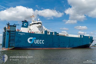
PTOLEMY
Vehicles Carrier
Current Trip
| Time Travelled | 17 h, 23 mins |
|---|---|
| Remaining Time | --- |
| Distance Travelled | --- |
| Remaining Distance | --- |
| AVG Speed | --- |
| MAX Speed | --- |
| AVG Wind | --- |
| MAX Wind | --- |
| MIN Temp | --- |
| MAX Temp | --- |
| Dybgang | 5.2 m |
| Position Modtaget | 2 d siden |
Current Position
| Longitude | 137.42103° |
|---|---|
| Latitude | 37.53805° |
| Status | Under way using engine |
| Fart | 12.7 Knots |
| Kurs | 354.4° |
| Område | Japan Sea |
| Station | T-AIS |
| Position Modtaget | 2 d siden |
Info
Information
The current position of PTOLEMY is in Japan Sea with coordinates 37.53805° / 137.42103° as reported on 2025-03-07 11:56 by AIS to our vessel tracker app. The vessel's current speed is 12.7 Knots
The vessel PTOLEMY (IMO: 9131967, MMSI: 352002257) is a Vehicles Carrier that was built in 1998 ( 27 år gamle ). It's sailing under the flag of [PA] Panama.
In this page you can find informations about the vessels current position, last detected port calls, and current voyage information. If the vessels is not in coverage by AIS you will find the latest position.
The current position of PTOLEMY is detected by our AIS receivers and we are not responsible for the reliability of the data. The last position was recorded while the vessel was in Coverage by the Ais receivers of our vessel tracking app.
The current draught of PTOLEMY as reported by AIS is 5.2 meters
Weather
| Temperature | 0.6°C / 33.08°F |
|---|---|
| Wind Speed | 8 knots |
| Direction | 146° SE |
| Pressure | 1028.3 hPa |
| Humidity | 83.8 % |
| Cloud Coverage | 4 % |
Featured Company
Last Port Calls
| Port | Arrival | Departure | Time In Port |
|---|---|---|---|
| 2025-03-08 19:13 | 2025-03-09 12:49 | 17 h | |
| 2025-02-15 16:49 | 2025-02-16 12:21 | 19 h | |
| 2025-02-10 06:05 | 2025-02-10 13:49 | 7 h |
Most Visited Ports (Last year)
| Port | Arrivals | |
|---|---|---|
| 34 | ||
| 1 |
Last Trips
| Origin | Departure | Destination | Arrival | Distance | |
|---|---|---|---|---|---|
| 2025-02-16 22:21 | 2025-03-09 05:13 | 957.32 nm | |||
| 2025-02-10 23:49 | 2025-02-16 02:49 | 945.96 nm | |||
| 2024-12-22 02:49 | 2025-02-10 16:05 | 6.04 nm |
Events
| Tid | Hændelsen | Detaljer | Position / Dest | Info |
|---|---|---|---|---|
| 2025-03-09 12:49 | Afsejlet fra sidste havn |
|
43.07157 / 131.88422
RUVVO
|
Fart: 8.4 kn Kurs: 123° |
| 2025-03-09 12:33 | START Sejllads |
43.09951 / 131.87782
[RU] VLADIVOSTOK
|
Fart: 6.6 kn Kurs: 180° |
|
| 2025-03-08 19:45 | STOP Sejllads |
43.10389 / 131.87756
[RU] VLADIVOSTOK
|
Fart: Kurs: 231° |
|
| 2025-03-08 19:13 | Skibe i havn |
|
43.08210 / 131.87544
[RU] VLADIVOSTOK
|
Fart: 6.2 kn Kurs: 322° |
| 2025-03-07 12:11 | Status er ændret | Default Under way using engine |
37.58949 / 137.39847
RUVVO
|
Fart: 12.7 kn Kurs: 354.4° |
| 2025-03-07 11:56 | Udenfor Dækning |
37.53805 / 137.42103
Japan Sea
RUVVO
|
Fart: 12.7 kn Kurs: 354.4° |
|
| 2025-03-07 10:59 | Dybgangen er ændret | 5.2 4.7 |
37.31959 / 137.38504
RUVVO
|
Fart: 14.8 kn Kurs: 15.1° |
| 2025-03-07 10:59 | Destination er ændret | RUVVO JPTOY |
37.31959 / 137.38504
RUVVO
|
Fart: 14.8 kn Kurs: 15.1° |
| 2025-03-07 10:59 | ETA er ændret | 2025/03/09 16:00 2026/02/28 23:30 |
37.31959 / 137.38504
RUVVO
|
Fart: 14.8 kn Kurs: 15.1° |
| 2025-03-07 10:10 | Status er ændret | Under way using engine Default |
37.13455 / 137.34195
JPTOY
|
Fart: 12.8 kn Kurs: 16° |