
SENIORITY
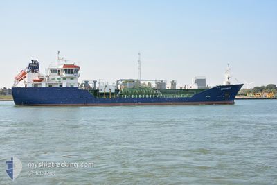
Oil/Chemical Tanker
Current Trip
| Time Travelled | 1 day |
|---|---|
| Remaining Time | 20 h, 17 mins |
| Distance Travelled | 232.47 nm |
| Remaining Distance | 192.26 nm |
| AVG Speed | 8.1 Knots |
| MAX Speed | 9.2 Knots |
| AVG Wind | 12.5 knots |
| MAX Wind | 20 knots |
| MIN Temp | 5.1°C / 41.18°F |
| MAX Temp | 7.1°C / 44.78°F |
| Dybgang | 5 m |
| Position Modtaget | 4 h, 4 m siden |
Current Position
| Longitude | 0.19192° |
|---|---|
| Latitude | 53.96183° |
| Status | Under way using engine |
| Fart | 8.8 Knots |
| Kurs | 157° |
| Område | North Sea |
| Station | T-AIS |
| Position Modtaget | 4 h, 4 m siden |
Info
Information
The current position of SENIORITY is in North Sea with coordinates 53.96183° / 0.19192° as reported on 2025-02-06 09:08 by AIS to our vessel tracker app. The vessel's current speed is 8.8 Knots and is heading at the port of AMSTERDAM. The estimated time of arrival as calculated by MyShipTracking vessel tracking app is 2025-02-07 09:30 LT
The vessel SENIORITY (IMO: 9285196, MMSI: 235098058) is a Oil/Chemical Tanker that was built in 2006 ( 19 år gamle ). It's sailing under the flag of [GB] United Kingdom.
In this page you can find informations about the vessels current position, last detected port calls, and current voyage information. If the vessels is not in coverage by AIS you will find the latest position.
The current position of SENIORITY is detected by our AIS receivers and we are not responsible for the reliability of the data. The last position was recorded while the vessel was in Coverage by the Ais receivers of our vessel tracking app.
The current draught of SENIORITY as reported by AIS is 5 meters
Weather
| Temperature | 6.1°C / 42.98°F |
|---|---|
| Wind Speed | 8 knots |
| Direction | 74° ENE |
| Pressure | 1044.9 hPa |
| Humidity | 88.9 % |
| Cloud Coverage | --- |
Featured Company
Last Port Calls
| Port | Arrival | Departure | Time In Port |
|---|---|---|---|
| 2025-02-04 07:47 | 2025-02-05 05:36 | 21 h | |
| 2025-02-02 15:36 | 2025-02-03 05:00 | 13 h | |
| 2025-01-27 17:56 | 2025-01-28 16:09 | 22 h | |
| 2025-01-20 10:57 | 2025-01-22 10:53 | 1 d | |
| 2025-01-19 14:33 | 2025-01-20 10:47 | 20 h | |
| 2025-01-17 13:59 | 2025-01-19 14:31 | 2 d | |
| 2025-01-14 19:50 | 2025-01-15 02:01 | 6 h | |
| 2025-01-13 21:28 | 2025-01-14 19:27 | 21 h | |
| 2025-01-11 06:01 | 2025-01-11 23:22 | 17 h | |
| 2025-01-08 15:31 | 2025-01-09 19:59 | 1 d |
Last Trips
| Origin | Departure | Destination | Arrival | Distance | |
|---|---|---|---|---|---|
| 2025-02-03 05:00 | 2025-02-04 07:47 | 255.00 nm | |||
| 2025-01-28 17:09 | 2025-02-02 15:36 | 748.62 nm | |||
| 2025-01-22 10:53 | 2025-01-27 18:56 | 604.49 nm | |||
| 2025-01-20 10:47 | 2025-01-20 10:57 | 0.45 nm | |||
| 2025-01-19 14:31 | 2025-01-19 14:33 | 0.05 nm | |||
| 2025-01-15 03:01 | 2025-01-17 13:59 | 590.11 nm | |||
| 2025-01-14 20:27 | 2025-01-14 20:50 | 1.84 nm | |||
| 2025-01-12 00:22 | 2025-01-13 22:28 | 395.17 nm | |||
| 2025-01-09 20:59 | 2025-01-11 07:01 | 335.28 nm | |||
| 2025-01-08 01:20 | 2025-01-08 16:31 | 97.81 nm |
Events
| Tid | Hændelsen | Detaljer | Position / Dest | Info |
|---|---|---|---|---|
| 2025-02-06 13:09 | STOP Sejllads | 18.55 nm, East of GRIMSBY |
53.67604 / .42436
AMSTERDAM
|
Fart: 0.1 kn Kurs: 176° |
| 2025-02-06 09:13 | Status er ændret | Default Under way using engine |
53.95087 / .19939
AMSTERDAM
|
Fart: 8.8 kn Kurs: 157° |
| 2025-02-06 09:08 | Status er ændret | Under way using engine Default |
53.96183 / .19192
AMSTERDAM
|
Fart: 8.7 kn Kurs: 157° |
| 2025-02-06 09:08 | Udenfor Dækning |
53.96183 / .19192
North Sea
AMSTERDAM
|
Fart: 8.8 kn Kurs: 157° |
|
| 2025-02-06 08:53 | Indenfor Dækning |
53.96183 / .19192
North Sea
AMSTERDAM
|
Fart: 8.8 kn Kurs: 157° |
|
| 2025-02-06 08:12 | Status er ændret | Default Under way using engine |
54.08751 / .10371
AMSTERDAM
|
Fart: 8.7 kn Kurs: 153° |
| 2025-02-06 07:59 | Status er ændret | Under way using engine Default |
54.11657 / .08308
AMSTERDAM
|
Fart: 8.6 kn Kurs: 153° |
| 2025-02-06 07:59 | Udenfor Dækning |
54.11657 / .08308
North Sea
AMSTERDAM
|
Fart: 8.7 kn Kurs: 153° |
|
| 2025-02-06 07:39 | Indenfor Dækning |
54.11657 / .08308
North Sea
AMSTERDAM
|
Fart: 8.7 kn Kurs: 153° |
|
| 2025-02-05 07:59 | Udenfor Dækning |
56.85200 / -2.04632
North Sea
AMSTERDAM
|
Fart: 7.4 kn Kurs: 188.9° |