
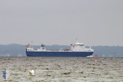
SIGRID
Nuclear Fuel Carrier
Current Trip
FOR ORDERS
| Time Travelled | 3 days |
|---|---|
| Remaining Time | --- |
| Distance Travelled | 252.15 nm |
| Remaining Distance | --- |
| AVG Speed | 7.4 Knots |
| MAX Speed | 12.7 Knots |
| AVG Wind | 18.5 knots |
| MAX Wind | 24 knots |
| MIN Temp | -2.2°C / 28.04°F |
| MAX Temp | 2.3°C / 36.14°F |
| Dybgang | 4.5 m |
| Position Modtaget | 1 d siden |
Current Position
| Longitude | 18.63120° |
|---|---|
| Latitude | 60.25856° |
| Status | Under way using engine |
| Fart | 12.6 Knots |
| Kurs | 303.1° |
| Område | Gulf of Bothnia |
| Station | T-AIS |
| Position Modtaget | 1 d siden |
Info
Information
The current position of SIGRID is in Gulf of Bothnia with coordinates 60.25856° / 18.63120° as reported on 2026-01-09 06:21 by AIS to our vessel tracker app. The vessel's current speed is 12.6 Knots
The vessel SIGRID (IMO: 9631840, MMSI: 266416000) is a Nuclear Fuel Carrier that was built in 2013 ( 13 år gamle ). It's sailing under the flag of [SE] Sweden.
In this page you can find informations about the vessels current position, last detected port calls, and current voyage information. If the vessels is not in coverage by AIS you will find the latest position.
The current position of SIGRID is detected by our AIS receivers and we are not responsible for the reliability of the data. The last position was recorded while the vessel was in Coverage by the Ais receivers of our vessel tracking app.
The current draught of SIGRID as reported by AIS is 4.5 meters
Weather
| Temperature | -1.3°C / 29.66°F |
|---|---|
| Wind Speed | 27 knots |
| Direction | 15° NNE |
| Pressure | 1018.3 hPa |
| Humidity | 60.5 % |
| Cloud Coverage | 100 % |
Featured Company
Last Port Calls
| Port | Arrival | Departure | Time In Port |
|---|---|---|---|
| 2025-12-15 08:52 | 2026-01-07 18:18 | 23 d | |
| 2025-12-06 08:01 | 2025-12-13 13:00 | 7 d | |
| 2025-12-01 14:24 | 2025-12-04 14:08 | 2 d | |
| 2025-11-26 15:49 | 2025-11-29 17:18 | 3 d | |
| 2025-11-24 06:44 | 2025-11-24 10:07 | 3 h | |
| 2025-11-21 13:22 | 2025-11-21 19:11 | 5 h | |
| 2025-11-14 14:46 | 2025-11-14 19:24 | 4 h | |
| 2025-11-03 08:55 | 2025-11-07 13:40 | 4 d | |
| 2025-11-01 09:06 |
Most Visited Ports (Last year)
| Port | Arrivals | |
|---|---|---|
| 36 | ||
| 11 | ||
| 6 | ||
| 2 | ||
| 1 | ||
| 1 |
Last Trips
| Origin | Departure | Destination | Arrival | Distance | |
|---|---|---|---|---|---|
| 2025-12-13 13:00 | 2025-12-15 08:52 | 387.29 nm | |||
| 2025-12-04 14:08 | 2025-12-06 08:01 | 376.51 nm | |||
| 2025-11-29 17:18 | 2025-12-01 14:24 | 391.13 nm | |||
| 2025-11-24 10:07 | 2025-11-26 15:49 | 665.02 nm | |||
| 2025-11-21 19:11 | 2025-11-24 06:44 | 331.00 nm | |||
| 2025-11-14 19:24 | 2025-11-21 13:22 | 1626.60 nm | |||
| 2025-11-07 13:40 | 2025-11-14 14:46 | 1270.07 nm | |||
| 2025-11-01 09:06 | 2025-11-03 08:55 | 376.69 nm |
Events
| Tid | Hændelsen | Detaljer | Position / Dest | Info |
|---|---|---|---|---|
| 2026-01-09 08:17 | STOP Sejllads | 8.35 nm, North West of GRASO |
60.40732 / 18.21026
FOR ORDERS
|
Fart: 0.3 kn Kurs: 159° |
| 2026-01-09 06:29 | Status er ændret | Default Under way using engine |
60.27410 / 18.59147
FOR ORDERS
|
Fart: 12.6 kn Kurs: 303.1° |
| 2026-01-09 06:21 | Udenfor Dækning |
60.25856 / 18.63120
Gulf of Bothnia
|
Fart: 12.6 kn Kurs: 303.1° |
|
| 2026-01-09 01:08 | Ændre havområde | Swedish part of the Gulf of Bothnia Finnish part of the Gulf of Bothnia |
59.86299 / 19.55085
Gulf of Bothnia
|
Fart: 6.2 kn Kurs: 296.1° |
| 2026-01-08 23:56 | Ændre havområde | Finnish part of the Gulf of Bothnia Finnish part of the Baltic Sea |
59.79062 / 19.74500
Gulf of Bothnia
|
Fart: 6 kn Kurs: 318.1° |
| 2026-01-08 21:35 | Fundet i havområde | Finnish part of the Baltic Sea |
59.61596 / 20.06678
Baltic Sea
|
Fart: 6.5 kn Kurs: 315.4° |
| 2026-01-08 21:34 | Indenfor Dækning |
59.61596 / 20.06678
Baltic Sea
|
Fart: 6.5 kn Kurs: 315.4° |
|
| 2026-01-08 21:32 | Status er ændret | Under way using engine Default |
59.61238 / 20.07391
FOR ORDERS
|
Fart: 6.5 kn Kurs: 316° |
| 2026-01-08 13:09 | Status er ændret | Default Under way using engine |
58.93994 / 19.23868
FOR ORDERS
|
Fart: 5.9 kn Kurs: 41.9° |
| 2026-01-08 13:02 | Udenfor Dækning |
58.93152 / 19.22447
Baltic Sea
|
Fart: 5.9 kn Kurs: 41.9° |