
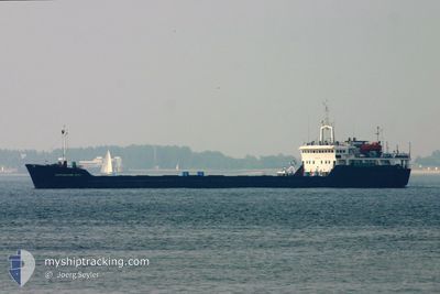
SORMOVSKIY 3053
General Cargo
Current Trip
| Time Travelled | 5 days |
|---|---|
| Remaining Time | --- |
| Distance Travelled | 819.66 nm |
| Remaining Distance | --- |
| AVG Speed | 7.4 Knots |
| MAX Speed | 9.2 Knots |
| AVG Wind | 9.3 knots |
| MAX Wind | 29.8 knots |
| MIN Temp | 6.5°C / 43.7°F |
| MAX Temp | 19.9°C / 67.82°F |
| Dybgang | 4.1 m |
| Position Modtaget | 1 h, 42 m siden |
Current Position
| Longitude | 26.33514° |
|---|---|
| Latitude | 39.42399° |
| Status | Under way using engine |
| Fart | 7.9 Knots |
| Kurs | 95° |
| Område | Aegean Sea |
| Station | T-AIS |
| Position Modtaget | 1 h, 42 m siden |
Info
Information
The current position of SORMOVSKIY 3053 is in Aegean Sea with coordinates 39.42399° / 26.33514° as reported on 2025-03-13 11:40 by AIS to our vessel tracker app. The vessel's current speed is 7.9 Knots and is heading at the port of MERSIN. The estimated time of arrival as calculated by MyShipTracking vessel tracking app is 2025-03-18 23:00 LT
The vessel SORMOVSKIY 3053 (IMO: 8222381, MMSI: 273329500) is a General Cargo that was built in 1985 ( 40 år gamle ). It's sailing under the flag of [RU] Russia.
In this page you can find informations about the vessels current position, last detected port calls, and current voyage information. If the vessels is not in coverage by AIS you will find the latest position.
The current position of SORMOVSKIY 3053 is detected by our AIS receivers and we are not responsible for the reliability of the data. The last position was recorded while the vessel was in Coverage by the Ais receivers of our vessel tracking app.
The current draught of SORMOVSKIY 3053 as reported by AIS is 4.1 meters
Weather
| Temperature | 18.9°C / 66.02°F |
|---|---|
| Wind Speed | 24 knots |
| Direction | 173° S |
| Pressure | 1011.4 hPa |
| Humidity | 51.7 % |
| Cloud Coverage | 92 % |
Featured Company
Last Port Calls
| Port | Arrival | Departure | Time In Port |
|---|---|---|---|
| 2025-03-07 13:57 | |||
| 2025-02-05 13:37 | 2025-02-12 23:53 | 7 d | |
| 2025-01-13 14:43 | 2025-01-16 17:23 | 3 d |
Last Trips
| Origin | Departure | Destination | Arrival | Distance | |
|---|---|---|---|---|---|
| 2025-01-16 20:23 | 2025-02-05 16:37 | 1256.01 nm | |||
| 2024-12-07 02:36 | 2025-01-13 17:43 | 2542.92 nm |
Events
| Tid | Hændelsen | Detaljer | Position / Dest | Info |
|---|---|---|---|---|
| 2025-03-13 11:50 | Status er ændret | Default Under way using engine |
39.42123 / 26.36412
TR MER
|
Fart: 7.9 kn Kurs: 95° |
| 2025-03-13 11:40 | Fundet i havområde | Greek part of the Aegean Sea |
39.42399 / 26.33514
Aegean Sea
TR MER
|
Fart: 7.9 kn Kurs: 95° |
| 2025-03-13 11:40 | Udenfor Dækning |
39.42399 / 26.33514
Aegean Sea
TR MER
|
Fart: 7.9 kn Kurs: 95° |
|
| 2025-03-13 08:38 | Dybgangen er ændret | 4.1 4.2 |
39.57454 / 26.06249
TR MER
|
Fart: 6.9 kn Kurs: 191.6° |
| 2025-03-13 08:14 | Status er ændret | Under way using engine Default |
39.61944 / 26.07614
TR MER
|
Fart: 6.8 kn Kurs: 192° |
| 2025-03-13 08:01 | Status er ændret | Default Under way using engine |
39.64359 / 26.08335
TR MER
|
Fart: 7.2 kn Kurs: 192.3° |
| 2025-03-13 06:11 | Fundet i havområde | Turkish part of the Aegean Sea |
39.85045 / 26.08532
Aegean Sea
TR MER
|
Fart: 7.8 kn Kurs: 189.5° |
| 2025-03-13 06:11 | Status er ændret | Under way using engine Default |
39.85045 / 26.08532
TR MER
|
Fart: 7.7 kn Kurs: 197° |
| 2025-03-13 06:11 | Indenfor Dækning |
39.85045 / 26.08532
Aegean Sea
TR MER
|
Fart: 7.8 kn Kurs: 189.5° |
|
| 2025-03-13 04:00 | Udenfor Dækning |
40.07353 / 26.29313
Sea of Marmara
TR MER
|
Fart: 8.9 kn Kurs: 232.2° |