
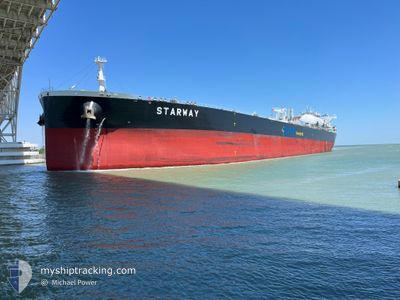
STARWAY
Tanker
Current Trip
| Time Travelled | 38 days |
|---|---|
| Remaining Time | --- |
| Distance Travelled | 9083.10 nm |
| Remaining Distance | --- |
| AVG Speed | 10.8 Knots |
| MAX Speed | 14.9 Knots |
| AVG Wind | 13.4 knots |
| MAX Wind | 29 knots |
| MIN Temp | 6.6°C / 43.88°F |
| MAX Temp | 27.3°C / 81.14°F |
| Dybgang | 10.3 m |
| Position Modtaget | 5 m siden |
Current Position
| Longitude | -5.35785° |
|---|---|
| Latitude | 36.10539° |
| Status | At anchor |
| Fart | |
| Kurs | 332° |
| Område | Strait of Gibraltar |
| Station | T-AIS |
| Position Modtaget | 5 m siden |
Info
Information
The current position of STARWAY is in Strait of Gibraltar with coordinates 36.10539° / -5.35785° as reported on 2025-02-07 00:35 by AIS to our vessel tracker app. The vessel's current speed is 0 Knots
The vessel STARWAY (IMO: 9900801, MMSI: 636021146) is a Tanker It's sailing under the flag of [LR] Liberia.
In this page you can find informations about the vessels current position, last detected port calls, and current voyage information. If the vessels is not in coverage by AIS you will find the latest position.
The current position of STARWAY is detected by our AIS receivers and we are not responsible for the reliability of the data. The last position was recorded while the vessel was in Coverage by the Ais receivers of our vessel tracking app.
The current draught of STARWAY as reported by AIS is 10.3 meters
Weather
| Temperature | 14.7°C / 58.46°F |
|---|---|
| Wind Speed | 9 knots |
| Direction | 106° ESE |
| Pressure | 1025.8 hPa |
| Humidity | 74 % |
| Cloud Coverage | 3 % |
Featured Company
Most Visited Ports (Last year)
| Port | Arrivals | |
|---|---|---|
| 6 | ||
| 2 | ||
| 2 | ||
| 1 | ||
| 1 |
Events
| Tid | Hændelsen | Detaljer | Position / Dest | Info |
|---|---|---|---|---|
| 2025-02-06 23:08 | STOP Sejllads | 2.46 nm, South of GIBRALTAR |
36.10661 / -5.35757
GI GIB
|
Fart: 0.3 kn Kurs: 316° |
| 2025-02-06 23:02 | Status er ændret | At anchor Under way using engine |
36.10646 / -5.35863
GI GIB
|
Fart: 0.5 kn Kurs: 318° |
| 2025-02-06 22:32 | Ændre havområde | Gibraltarian part of the Strait of Gibraltar Gibraltarian part of the Alboran Sea |
36.08061 / -5.33421
Strait of Gibraltar
GI GIB
|
Fart: 3.1 kn Kurs: 287.4° |
| 2025-02-06 22:32 | START Sejllads | 4.24 nm, South of GIBRALTAR |
36.08061 / -5.33421
GI GIB
|
Fart: 3.1 kn Kurs: 297° |
| 2025-02-06 22:14 | Ændre havområde | Gibraltarian part of the Alboran Sea Gibraltarian part of the Strait of Gibraltar |
36.08555 / -5.33444
Alboran Sea
GI GIB
|
Fart: 0.8 kn Kurs: 120.2° |
| 2025-02-06 21:56 | Ændre havområde | Gibraltarian part of the Strait of Gibraltar Gibraltarian part of the Alboran Sea |
36.08793 / -5.33529
Strait of Gibraltar
GI GIB
|
Fart: 1 kn Kurs: 276.3° |
| 2025-02-06 21:43 | STOP Sejllads | 3.98 nm, South of GIBRALTAR |
36.08543 / -5.33349
GI GIB
|
Fart: 0.3 kn Kurs: 309° |
| 2025-02-06 20:11 | Ændre havområde | Gibraltarian part of the Alboran Sea Spanish part of the Alboran Sea |
36.13538 / -5.12080
Alboran Sea
GI GIB
|
Fart: 7.7 kn Kurs: 238.4° |
| 2025-02-06 13:05 | ETA er ændret | 2025/02/06 22:00 2025/02/06 21:00 |
36.24218 / -3.55380
GI GIB
|
Fart: 12.2 kn Kurs: 268.7° |
| 2025-02-06 12:41 | Status er ændret | Under way using engine Default |
36.24171 / -3.45354
GI GIB
|
Fart: 11.6 kn Kurs: 271° |