
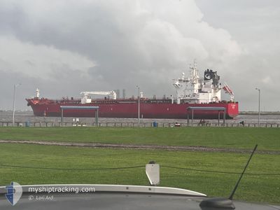
STI LEBLON
Tanker
Current Trip
| Time Travelled | 9 days |
|---|---|
| Remaining Time | --- |
| Distance Travelled | 653.31 nm |
| Remaining Distance | --- |
| AVG Speed | 11.9 Knots |
| MAX Speed | 13.4 Knots |
| AVG Wind | 10 knots |
| MAX Wind | 18 knots |
| MIN Temp | 13.7°C / 56.66°F |
| MAX Temp | 25.4°C / 77.72°F |
| Dybgang | 8.7 m |
| Position Modtaget | 4 d siden |
Current Position
| Longitude | -94.45560° |
|---|---|
| Latitude | 28.95419° |
| Status | At anchor |
| Fart | |
| Kurs | 170° |
| Område | Gulf of Mexico |
| Station | T-AIS |
| Position Modtaget | 4 d siden |
Info
Information
The current position of STI LEBLON is in Gulf of Mexico with coordinates 28.95419° / -94.45560° as reported on 2025-02-04 09:49 by AIS to our vessel tracker app. The vessel's current speed is 0 Knots
The vessel STI LEBLON (IMO: 9785706, MMSI: 538007039) is a Tanker It's sailing under the flag of [MH] Marshall Is.
In this page you can find informations about the vessels current position, last detected port calls, and current voyage information. If the vessels is not in coverage by AIS you will find the latest position.
The current position of STI LEBLON is detected by our AIS receivers and we are not responsible for the reliability of the data. The last position was recorded while the vessel was in Coverage by the Ais receivers of our vessel tracking app.
The current draught of STI LEBLON as reported by AIS is 8.7 meters
Weather
| Temperature | 24.1°C / 75.38°F |
|---|---|
| Wind Speed | 4 knots |
| Direction | 100° E |
| Pressure | 1016.5 hPa |
| Humidity | 81 % |
| Cloud Coverage | --- |
Featured Company
Last Port Calls
| Port | Arrival | Departure | Time In Port |
|---|---|---|---|
| 2025-01-27 20:29 | 2025-01-29 21:42 | 2 d | |
| 2025-01-03 19:43 | 2025-01-03 20:25 | 41 m | |
| 2024-12-10 14:02 | 2024-12-11 21:52 | 1 d | |
| 2024-12-02 03:34 | 2024-12-03 23:17 | 1 d |
Most Visited Ports (Last year)
| Port | Arrivals | |
|---|---|---|
| 5 | ||
| 2 | ||
| 2 | ||
| 2 | ||
| 2 | ||
| 1 |
Last Trips
| Origin | Departure | Destination | Arrival | Distance | |
|---|---|---|---|---|---|
| 2025-01-03 14:25 | 2025-01-27 14:29 | 2740.47 nm | |||
| 2024-12-11 15:52 | 2025-01-03 13:43 | 1677.58 nm | |||
| 2024-12-03 18:17 | 2024-12-10 08:02 | 1177.87 nm | |||
| 2024-11-24 13:21 | 2024-12-01 22:34 | 23.35 nm |
Events
| Tid | Hændelsen | Detaljer | Position / Dest | Info |
|---|---|---|---|---|
| 2025-02-07 15:58 | STOP Sejllads | 6.68 nm, North East of BOCA DEL RIO |
19.16770 / -96.01001
MX VER
|
Fart: 0.2 kn Kurs: 183° |
| 2025-02-05 16:38 | START Sejllads |
28.93517 / -94.44703
MX VER
|
Fart: 8.5 kn Kurs: 161° |
|
| 2025-02-04 09:55 | Status er ændret | Default At anchor |
28.95420 / -94.45562
MX VER
|
Fart: Kurs: 170° |
| 2025-02-04 09:49 | Status er ændret | At anchor Default |
28.95419 / -94.45560
MX VER
|
Fart: Kurs: 168° |
| 2025-02-04 09:49 | Udenfor Dækning |
28.95419 / -94.45560
Gulf of Mexico
MX VER
|
Fart: Kurs: 181° |
|
| 2025-02-04 09:31 | Status er ændret | Default At anchor |
28.95420 / -94.45564
MX VER
|
Fart: Kurs: 166° |
| 2025-02-04 09:25 | Status er ændret | At anchor Default |
28.95420 / -94.45565
MX VER
|
Fart: Kurs: 166° |
| 2025-02-04 09:25 | Indenfor Dækning |
28.95420 / -94.45565
Gulf of Mexico
MX VER
|
Fart: Kurs: 181° |
|
| 2025-02-02 00:01 | Status er ændret | Default At anchor |
28.95394 / -94.45618
MX VER
|
Fart: Kurs: 146° |
| 2025-02-01 23:55 | Udenfor Dækning |
28.95397 / -94.45616
Gulf of Mexico
MX VER
|
Fart: Kurs: 51.2° |