
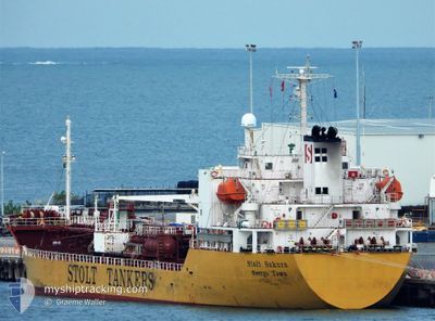
STOLT SAKURA
Oil/Chemical Tanker
Current Trip
| Time Travelled | 1 day |
|---|---|
| Remaining Time | 1 day |
| Distance Travelled | 423.32 nm |
| Remaining Distance | 447.58 nm |
| AVG Speed | 11.3 Knots |
| MAX Speed | 13 Knots |
| AVG Wind | 22.7 knots |
| MAX Wind | 28.9 knots |
| MIN Temp | 17.2°C / 62.96°F |
| MAX Temp | 26.3°C / 79.34°F |
| Dybgang | 7.5 m |
| Position Modtaget | 12 h, 54 m siden |
Current Position
| Longitude | 112.91326° |
|---|---|
| Latitude | -27.94535° |
| Status | Under way using engine |
| Fart | 12.2 Knots |
| Kurs | 330.4° |
| Område | Indian Ocean |
| Station | T-AIS |
| Position Modtaget | 12 h, 54 m siden |
Info
Information
The current position of STOLT SAKURA is in Indian Ocean with coordinates -27.94535° / 112.91326° as reported on 2025-02-13 17:08 by AIS to our vessel tracker app. The vessel's current speed is 12.2 Knots and is heading at the port of FREMANTLE. The estimated time of arrival as calculated by MyShipTracking vessel tracking app is 2025-02-16 02:36 LT
The vessel STOLT SAKURA (IMO: 9432969, MMSI: 563206500) is a Oil/Chemical Tanker that was built in 2010 ( 15 år gamle ). It's sailing under the flag of [SG] Singapore.
In this page you can find informations about the vessels current position, last detected port calls, and current voyage information. If the vessels is not in coverage by AIS you will find the latest position.
The current position of STOLT SAKURA is detected by our AIS receivers and we are not responsible for the reliability of the data. The last position was recorded while the vessel was in Coverage by the Ais receivers of our vessel tracking app.
The current draught of STOLT SAKURA as reported by AIS is 7.5 meters
Weather
| Temperature | 26.2°C / 79.16°F |
|---|---|
| Wind Speed | 15 knots |
| Direction | 133° SE |
| Pressure | 1009.7 hPa |
| Humidity | 62.3 % |
| Cloud Coverage | --- |
Featured Company
Last Port Calls
| Port | Arrival | Departure | Time In Port |
|---|---|---|---|
| 2025-02-11 15:51 | 2025-02-12 16:36 | 1 d | |
| 2025-02-01 04:13 | 2025-02-01 17:49 | 13 h | |
| 2025-01-26 08:11 | 2025-01-27 18:11 | 1 d | |
| 2025-01-23 02:51 | 2025-01-23 23:38 | 20 h | |
| 2025-01-09 19:59 | 2025-01-11 01:28 | 1 d | |
| 2024-12-29 18:22 | 2024-12-30 08:32 | 14 h | |
| 2024-12-27 14:48 | 2024-12-28 08:22 | 17 h | |
| 2024-12-24 05:56 | 2024-12-25 02:24 | 20 h | |
| 2024-12-17 03:30 | 2024-12-18 13:09 | 1 d | |
| 2024-12-09 08:14 | 2024-12-12 00:18 | 2 d |
Most Visited Ports (Last year)
| Port | Arrivals | |
|---|---|---|
| 10 | ||
| 8 | ||
| 5 | ||
| 4 | ||
| 4 | ||
| 4 |
Last Trips
| Origin | Departure | Destination | Arrival | Distance | |
|---|---|---|---|---|---|
| 2025-02-02 03:49 | 2025-02-11 23:51 | 2697.15 nm | |||
| 2025-01-28 05:11 | 2025-02-01 14:13 | 1119.39 nm | |||
| 2025-01-24 10:38 | 2025-01-26 19:11 | 655.35 nm | |||
| 2025-01-11 12:28 | 2025-01-23 13:51 | 1900.51 nm | |||
| 2024-12-30 21:32 | 2025-01-10 06:59 | 1909.61 nm | |||
| 2024-12-28 21:22 | 2024-12-30 07:22 | 300.42 nm | |||
| 2024-12-25 15:24 | 2024-12-28 03:48 | 346.46 nm | |||
| 2024-12-19 00:09 | 2024-12-24 18:56 | 1529.48 nm | |||
| 2024-12-12 11:18 | 2024-12-17 14:30 | 621.72 nm | |||
| 2024-12-02 17:18 | 2024-12-09 19:14 | 615.78 nm |
Events
| Tid | Hændelsen | Detaljer | Position / Dest | Info |
|---|---|---|---|---|
| 2025-02-13 17:08 | Status er ændret | Default Under way using engine |
-27.94384 / 112.91228
FREMANTLE AU FRE
|
Fart: 12.2 kn Kurs: 330.4° |
| 2025-02-13 17:08 | Status er ændret | Under way using engine Default |
-27.94535 / 112.91326
FREMANTLE AU FRE
|
Fart: 12.4 kn Kurs: 332° |
| 2025-02-13 17:08 | Udenfor Dækning |
-27.94535 / 112.91326
Indian Ocean
|
Fart: 12.2 kn Kurs: 330.4° |
|
| 2025-02-13 16:48 | Indenfor Dækning |
-27.94535 / 112.91326
Indian Ocean
|
Fart: 12.2 kn Kurs: 330.4° |
|
| 2025-02-13 10:51 | Status er ændret | Default Under way using engine |
-29.03899 / 113.62052
FREMANTLE AU FRE
|
Fart: 11.2 kn Kurs: 331.1° |
| 2025-02-13 10:45 | Status er ændret | Under way using engine Default |
-29.05619 / 113.63081
FREMANTLE AU FRE
|
Fart: 11 kn Kurs: 328° |
| 2025-02-13 10:45 | Udenfor Dækning |
-29.05619 / 113.63081
Indian Ocean
|
Fart: 11.2 kn Kurs: 331.1° |
|
| 2025-02-13 10:33 | Indenfor Dækning |
-29.05619 / 113.63081
Indian Ocean
|
Fart: 11.2 kn Kurs: 331.1° |
|
| 2025-02-12 16:36 | Afsejlet fra sidste havn |
|
-32.05573 / 115.71353
FREMANTLE AU FRE
|
Fart: 8.2 kn Kurs: 262° |
| 2025-02-12 16:32 | START Sejllads |
-32.05524 / 115.72652
[AU] NORTH FREMANTLE
|
Fart: 8.2 kn Kurs: 262° |