
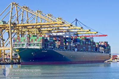
TITAN
Cargo
Current Trip
| Time Travelled | 7 days |
|---|---|
| Remaining Time | --- |
| Distance Travelled | 2919.96 nm |
| Remaining Distance | --- |
| AVG Speed | 15.6 Knots |
| MAX Speed | 19 Knots |
| AVG Wind | 10.1 knots |
| MAX Wind | 19.9 knots |
| MIN Temp | 18.3°C / 64.94°F |
| MAX Temp | 25.8°C / 78.44°F |
| Dybgang | 12 m |
| Position Modtaget | 5 d siden |
Current Position
| Longitude | -67.02880° |
|---|---|
| Latitude | 32.80146° |
| Status | Under way using engine |
| Fart | 14 Knots |
| Kurs | 122.2° |
| Område | North Atlantic Ocean |
| Station | T-AIS |
| Position Modtaget | 5 d siden |
Information
The current position of TITAN is in North Atlantic Ocean with coordinates 32.80146° / -67.02880° as reported on 2025-05-10 19:59 by AIS to our vessel tracker app. The vessel's current speed is 14 Knots and is heading at the port of PORT KLANG. The estimated time of arrival as calculated by MyShipTracking vessel tracking app is 2025-06-14 17:00 LT
The vessel TITAN (IMO: 9728928, MMSI: 249558000) is a Cargo It's sailing under the flag of [MT] Malta.
In this page you can find informations about the vessels current position, last detected port calls, and current voyage information. If the vessels is not in coverage by AIS you will find the latest position.
The current position of TITAN is detected by our AIS receivers and we are not responsible for the reliability of the data. The last position was recorded while the vessel was in Coverage by the Ais receivers of our vessel tracking app.
The current draught of TITAN as reported by AIS is 12 meters
Weather
| Temperature | 25.7°C / 78.26°F |
|---|---|
| Wind Speed | 14 knots |
| Direction | 65° ENE |
| Pressure | 1012.8 hPa |
| Humidity | 74.6 % |
| Cloud Coverage | 95 % |
Featured Company
Last Port Calls
| Port | Arrival | Departure | Time In Port |
|---|---|---|---|
| 2025-05-07 07:32 | 2025-05-08 21:35 | 1 d | |
| 2025-05-04 18:42 | 2025-05-06 06:31 | 1 d | |
| 2025-05-01 07:42 | 2025-05-03 12:33 | 2 d | |
| 2025-04-26 09:23 | 2025-04-28 03:44 | 1 d | |
| 2025-04-21 04:16 | 2025-04-22 17:39 | 1 d | |
| 2025-03-29 03:09 | 2025-03-30 15:46 | 1 d | |
| 2025-03-27 19:19 | 2025-03-28 16:05 | 20 h | |
| 2025-03-24 19:30 | 2025-03-26 21:48 | 2 d | |
| 2025-03-15 20:34 | 2025-03-17 05:26 | 1 d |
Last Trips
| Origin | Departure | Destination | Arrival | Distance | |
|---|---|---|---|---|---|
| 2025-05-06 02:31 | 2025-05-07 03:32 | 204.75 nm | |||
| 2025-05-03 08:33 | 2025-05-04 14:42 | 305.56 nm | |||
| 2025-04-27 23:44 | 2025-05-01 03:42 | 739.69 nm | |||
| 2025-04-22 12:39 | 2025-04-26 05:23 | 1578.91 nm | |||
| 2025-03-30 23:46 | 2025-04-20 23:16 | 9344.53 nm | |||
| 2025-03-29 00:05 | 2025-03-29 11:09 | 73.67 nm | |||
| 2025-03-27 05:48 | 2025-03-28 03:19 | 356.28 nm | |||
| 2025-03-17 13:26 | 2025-03-25 03:30 | 2201.08 nm | |||
| 2025-02-11 07:17 | 2025-03-16 04:34 | 12634.09 nm |
Events
| Tid | Hændelsen | Detaljer | Position / Dest | Info |
|---|---|---|---|---|
| 2025-05-10 19:59 | Status er ændret | Default Under way using engine |
32.80025 / -67.02652
MYPKG
|
Fart: 14 kn Kurs: 122.2° |
| 2025-05-10 19:59 | Udenfor Dækning |
32.80146 / -67.02880
North Atlantic Ocean
|
Fart: 14 kn Kurs: 122.2° |
|
| 2025-05-10 19:57 | Status er ændret | Under way using engine Default |
32.80591 / -67.03710
MYPKG
|
Fart: 13.9 kn Kurs: 122° |
| 2025-05-10 19:57 | Indenfor Dækning |
32.80146 / -67.02880
North Atlantic Ocean
|
Fart: 14 kn Kurs: 122.2° |
|
| 2025-05-10 18:04 | Status er ændret | Default Under way using engine |
33.03101 / -67.48194
MYPKG
|
Fart: 14 kn Kurs: 122.1° |
| 2025-05-10 17:49 | Udenfor Dækning |
33.06203 / -67.54004
North Atlantic Ocean
|
Fart: 14 kn Kurs: 122.1° |
|
| 2025-05-10 17:09 | Status er ændret | Under way using engine Default |
33.14526 / -67.69554
MYPKG
|
Fart: 13.7 kn Kurs: 122° |
| 2025-05-10 16:40 | Status er ændret | Default Under way using engine |
33.20512 / -67.80967
MYPKG
|
Fart: 13.8 kn Kurs: 121.4° |
| 2025-05-10 16:26 | Status er ændret | Under way using engine Default |
33.23308 / -67.86403
MYPKG
|
Fart: 13.8 kn Kurs: 122° |
| 2025-05-10 16:20 | Status er ændret | Default Under way using engine |
33.24514 / -67.88751
MYPKG
|
Fart: 13.8 kn Kurs: 121.4° |