
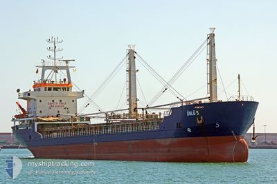
UNLU-5
General Cargo
Current Trip
| Trip Time | 2 days |
|---|---|
| Trip Distance | 863.12 nm |
| AVG Speed | 12 Knots |
| MAX Speed | 12 Knots |
| Dybgang | 6.1 m |
| AVG Wind | 11.5 knots |
| MAX Wind | 24 knots |
| MIN Temp | 9.4°C / 48.92°F |
| MAX Temp | 17.3°C / 63.14°F |
| Position Modtaget | 1 d siden |
Current Position
| Longitude | 33.41434° |
|---|---|
| Latitude | 45.11768° |
| Status | Under way using engine |
| Fart | 13.1 Knots |
| Kurs | 316° |
| Område | Black Sea |
| Station | T-AIS |
| Position Modtaget | 1 d siden |
Info
Information
The current position of UNLU-5 is in Black Sea with coordinates 45.11768° / 33.41434° as reported on 2025-03-13 01:18 by AIS to our vessel tracker app. The vessel's current speed is 13.1 Knots and is currently inside the port of VARNA.
The vessel UNLU-5 (IMO: 9334416, MMSI: 271000854) is a General Cargo that was built in 2006 ( 19 år gamle ). It's sailing under the flag of [TR] Turkey.
In this page you can find informations about the vessels current position, last detected port calls, and current voyage information. If the vessels is not in coverage by AIS you will find the latest position.
The current position of UNLU-5 is detected by our AIS receivers and we are not responsible for the reliability of the data. The last position was recorded while the vessel was in Coverage by the Ais receivers of our vessel tracking app.
The current draught of UNLU-5 as reported by AIS is 6.1 meters
Weather
| Temperature | 15.6°C / 60.08°F |
|---|---|
| Wind Speed | 3 knots |
| Direction | 187° S |
| Pressure | 1013.4 hPa |
| Humidity | 67.4 % |
| Cloud Coverage | 29 % |
Featured Company
Last Port Calls
| Port | Arrival | Departure | Time In Port |
|---|---|---|---|
| 2025-03-13 18:29 | |||
| 2025-03-05 22:54 | 2025-03-10 21:17 | 4 d | |
| 2025-02-23 16:52 | 2025-02-25 13:05 | 1 d | |
| 2025-02-14 15:19 | 2025-02-20 22:50 | 6 d | |
| 2025-02-04 11:31 | 2025-02-11 01:11 | 6 d | |
| 2025-01-12 23:32 | 2025-01-13 21:08 | 21 h | |
| 2025-01-03 19:01 | 2025-01-04 14:20 | 19 h |
Last Trips
| Origin | Departure | Destination | Arrival | Distance | |
|---|---|---|---|---|---|
| 2025-03-10 21:17 | 2025-03-13 18:29 | 863.12 nm | |||
| 2025-02-25 13:05 | 2025-03-05 22:54 | 673.17 nm | |||
| 2025-02-20 22:50 | 2025-02-23 16:52 | 250.09 nm | |||
| 2025-02-11 01:11 | 2025-02-14 15:19 | 33.58 nm | |||
| 2025-01-13 21:08 | 2025-02-04 11:31 | 979.76 nm | |||
| 2025-01-04 14:20 | 2025-01-12 23:32 | 505.98 nm | |||
| 2024-12-24 06:29 | 2025-01-03 19:01 | 414.71 nm |
Events
| Tid | Hændelsen | Detaljer | Position / Dest | Info |
|---|---|---|---|---|
| 2025-03-13 18:22 | STOP Sejllads |
43.18908 / 27.65670
[BG] VARNA
|
Fart: 0.1 kn Kurs: 278° |
|
| 2025-03-13 16:29 | Skibe i havn |
|
43.18413 / 27.91432
[BG] VARNA
|
Fart: 7 kn Kurs: 261° |
| 2025-03-13 01:18 | Udenfor Dækning |
45.11768 / 33.41434
Black Sea
BG VAR
|
Fart: 13.1 kn Kurs: 316° |
|
| 2025-03-13 00:41 | Indenfor Dækning |
45.11874 / 33.41252
Black Sea
BG VAR
|
Fart: 7.7 kn Kurs: 270.1° |
|
| 2025-03-12 23:39 | Udenfor Dækning |
45.33660 / 33.66175
Black Sea
BG VAR
|
Fart: 11.8 kn Kurs: 350° |
|
| 2025-03-12 23:21 | Indenfor Dækning |
45.33260 / 33.66533
Black Sea
BG VAR
|
Fart: 7.8 kn Kurs: 359.8° |
|
| 2025-03-12 22:10 | Udenfor Dækning |
45.33103 / 33.66655
Black Sea
BG VAR
|
Fart: 5.6 kn Kurs: 9° |
|
| 2025-03-12 21:22 | Ændre havområde | Ukrainian part of the Black Sea Turkish part of the Black Sea |
45.11872 / 33.41711
Black Sea
BG VAR
|
Fart: 7.8 kn Kurs: 270.3° |
| 2025-03-12 21:12 | Dybgangen er ændret | 6.1 4.2 |
45.32532 / 33.66568
BG VAR
|
Fart: 3.7 kn Kurs: 275° |
| 2025-03-12 21:12 | Destination er ændret | BG VAR GE BUS |
45.32532 / 33.66568
BG VAR
|
Fart: 3.7 kn Kurs: 275° |