

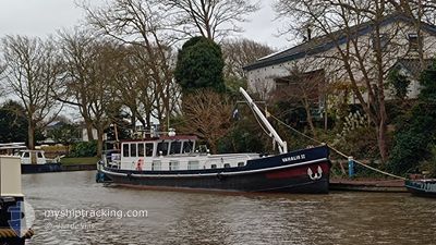
VAHALIS 2
Pleasure Craft

Current Trip
Current Position
| Longitude | 5.42419° |
|---|---|
| Latitude | 53.17271° |
| Status | Default |
| Fart | |
| Kurs | --- |
| Område | North Sea |
| Station | T-AIS |
| Position Modtaget | Nu |
Information
The current position of VAHALIS 2 is in North Sea with coordinates 53.17271° / 5.42419° as reported on 2025-04-15 21:12 by AIS to our vessel tracker app. The vessel's current speed is 0 Knots and is currently inside the port of HARLINGEN.
The vessel VAHALIS 2 (MMSI: 244010890) is a Pleasure Craft It's sailing under the flag of [NL] Netherlands.
In this page you can find informations about the vessels current position, last detected port calls, and current voyage information. If the vessels is not in coverage by AIS you will find the latest position.
The current position of VAHALIS 2 is detected by our AIS receivers and we are not responsible for the reliability of the data. The last position was recorded while the vessel was in Coverage by the Ais receivers of our vessel tracking app.
The current draught of VAHALIS 2 as reported by AIS is 1.2 meters
Weather
| Temperature | 10.5°C / 50.9°F |
|---|---|
| Wind Speed | 7 knots |
| Direction | 228° SW |
| Pressure | 999.7 hPa |
| Humidity | 93.7 % |
| Cloud Coverage | 100 % |


Featured Company
Last Port Calls
Most Visited Ports (Last year)
| Port | Arrivals | |
|---|---|---|
| 5 | ||
| 4 | ||
| 1 | ||
| 1 | ||
| 1 | ||
| 1 |
Last Trips
| Origin | Departure | Destination | Arrival | Distance |
|---|
Events
| Tid | Hændelsen | Detaljer | Position / Dest | Info |
|---|---|---|---|---|
| 2025-04-15 19:17 | Status er ændret | Default Under way using engine |
53.17269 / 5.42417
[NL] HARLINGEN
|
Fart: 96 kn Kurs: 511° |
| 2025-04-15 19:17 | Status er ændret | Under way using engine Default |
53.17271 / 5.42420
[NL] HARLINGEN
|
Fart: 0.3 kn Kurs: 511° |
| 2025-04-14 10:09 | Status er ændret | Default Under way using engine |
53.17275 / 5.42415
[NL] HARLINGEN
|
Fart: 96 kn Kurs: 511° |
| 2025-04-14 10:08 | Status er ændret | Under way using engine Default |
53.17273 / 5.42416
[NL] HARLINGEN
|
Fart: Kurs: 511° |
| 2025-04-13 22:59 | Status er ændret | Default Under way using engine |
53.17278 / 5.42414
[NL] HARLINGEN
|
Fart: 96 kn Kurs: 511° |
| 2025-04-13 22:59 | Status er ændret | Under way using engine Default |
53.17278 / 5.42413
[NL] HARLINGEN
|
Fart: Kurs: 511° |
| 2025-04-10 22:30 | Status er ændret | Default Under way using engine |
53.17269 / 5.42412
[NL] HARLINGEN
|
Fart: 96 kn Kurs: 511° |
| 2025-04-10 22:30 | Status er ændret | Under way using engine Default |
53.17271 / 5.42414
[NL] HARLINGEN
|
Fart: Kurs: 511° |
| 2025-04-10 11:21 | Status er ændret | Default Under way using engine |
53.17270 / 5.42422
[NL] HARLINGEN
|
Fart: 96 kn Kurs: 511° |
| 2025-04-10 11:21 | Status er ændret | Under way using engine Default |
53.17273 / 5.42422
[NL] HARLINGEN
|
Fart: Kurs: 511° |