

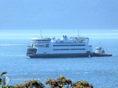
WSF KENNEWICK
Ro-Ro/Passenger Ship

Current Trip
| Time Travelled | 37 mins |
|---|---|
| Remaining Time | 24 mins |
| Distance Travelled | 3.90 nm |
| Remaining Distance | --- |
| AVG Speed | 8.8 Knots |
| MAX Speed | 12.7 Knots |
| AVG Wind | 9 knots |
| MAX Wind | 9 knots |
| MIN Temp | 9.3°C / 48.74°F |
| MAX Temp | 11.3°C / 52.34°F |
| Dybgang | 0 m |
| Position Modtaget | Nu |
Current Position
| Longitude | -122.67270° |
|---|---|
| Latitude | 48.15893° |
| Status | Under way using engine |
| Fart | |
| Kurs | 359° |
| Område | The Coastal Waters of Southeast Alaska and British Columbia |
| Station | T-AIS |
| Position Modtaget | Nu |
Information
The current position of WSF KENNEWICK is in The Coastal Waters of Southeast Alaska and British Columbia with coordinates 48.15893° / -122.67270° as reported on 2025-04-16 18:46 by AIS to our vessel tracker app. The vessel's current speed is 0 Knots and is heading at the port of PORT TOWNSEND. The estimated time of arrival as calculated by MyShipTracking vessel tracking app is 2025-04-16 12:11 LT
The vessel WSF KENNEWICK (IMO: 9618331, MMSI: 367479990) is a Ro-Ro/Passenger Ship that was built in 2011 ( 14 år gamle ). It's sailing under the flag of [US] USA.
In this page you can find informations about the vessels current position, last detected port calls, and current voyage information. If the vessels is not in coverage by AIS you will find the latest position.
The current position of WSF KENNEWICK is detected by our AIS receivers and we are not responsible for the reliability of the data. The last position was recorded while the vessel was in Coverage by the Ais receivers of our vessel tracking app.
Weather
| Temperature | 9.3°C / 48.74°F |
|---|---|
| Wind Speed | 9 knots |
| Direction | 314° NW |
| Pressure | 1018.7 hPa |
| Humidity | 78.3 % |
| Cloud Coverage | 7 % |


Featured Company
Last Port Calls
| Port | Arrival | Departure | Time In Port |
|---|---|---|---|
| 2025-04-16 10:43 | 2025-04-16 11:10 | 26 m | |
| 2025-04-16 09:14 | 2025-04-16 09:39 | 25 m | |
| 2025-04-16 07:41 | 2025-04-16 08:07 | 25 m | |
| 2025-04-15 21:34 | 2025-04-16 06:36 | 9 h | |
| 2025-04-15 19:53 | 2025-04-15 20:37 | 44 m | |
| 2025-04-15 18:24 | 2025-04-15 18:50 | 25 m | |
| 2025-04-15 16:43 | 2025-04-15 17:20 | 36 m | |
| 2025-04-15 15:13 | 2025-04-15 15:33 | 20 m | |
| 2025-04-15 13:44 | 2025-04-15 14:05 | 21 m | |
| 2025-04-15 12:16 | 2025-04-15 12:36 | 19 m |
Most Visited Ports (Last year)
| Port | Arrivals | |
|---|---|---|
| 3159 | ||
| 1 |
Last Trips
| Origin | Departure | Destination | Arrival | Distance | |
|---|---|---|---|---|---|
| 2025-04-16 09:39 | 2025-04-16 10:43 | 8.20 nm | |||
| 2025-04-16 08:07 | 2025-04-16 09:14 | 8.55 nm | |||
| 2025-04-16 06:36 | 2025-04-16 07:41 | 6.65 nm | |||
| 2025-04-15 20:37 | 2025-04-15 21:34 | 6.59 nm | |||
| 2025-04-15 18:50 | 2025-04-15 19:53 | 8.31 nm | |||
| 2025-04-15 17:20 | 2025-04-15 18:24 | 8.58 nm | |||
| 2025-04-15 15:33 | 2025-04-15 16:43 | 9.22 nm | |||
| 2025-04-15 14:05 | 2025-04-15 15:13 | 8.92 nm | |||
| 2025-04-15 12:36 | 2025-04-15 13:44 | 9.01 nm | |||
| 2025-04-15 11:09 | 2025-04-15 12:16 | 8.84 nm |
Events
| Tid | Hændelsen | Detaljer | Position / Dest | Info |
|---|---|---|---|---|
| 2025-04-16 18:33 | STOP Sejllads | 4.39 nm, North East of PORT TOWNSEND |
48.15894 / -122.67265
|
Fart: Kurs: 352° |
| 2025-04-16 18:10 | Afsejlet fra sidste havn |
|
48.11478 / -122.74130
WSFTERMINAL
|
Fart: 12.9 kn Kurs: 62° |
| 2025-04-16 18:06 | START Sejllads |
48.10948 / -122.75709
[US] PORT TOWNSEND
|
Fart: 7.5 kn Kurs: 114° |
|
| 2025-04-16 17:46 | STOP Sejllads |
48.11099 / -122.75893
[US] PORT TOWNSEND
|
Fart: 0.2 kn Kurs: 332° |
|
| 2025-04-16 17:43 | Skibe i havn |
|
48.10853 / -122.75513
[US] PORT TOWNSEND
|
Fart: 8.2 kn Kurs: 295.7° |
| 2025-04-16 17:19 | START Sejllads | 4.32 nm, North East of PORT TOWNSEND |
48.15675 / -122.67199
|
Fart: 8 kn Kurs: 167° |
| 2025-04-16 17:02 | STOP Sejllads | 4.39 nm, North East of PORT TOWNSEND |
48.15893 / -122.67266
|
Fart: 0.2 kn Kurs: 354° |
| 2025-04-16 16:39 | Afsejlet fra sidste havn |
|
48.11433 / -122.74200
WSFTERMINAL
|
Fart: 13.1 kn Kurs: 54° |
| 2025-04-16 16:36 | START Sejllads |
48.10942 / -122.75720
[US] PORT TOWNSEND
|
Fart: 8.9 kn Kurs: 124° |
|
| 2025-04-16 16:14 | STOP Sejllads |
48.11098 / -122.75892
[US] PORT TOWNSEND
|
Fart: 0.3 kn Kurs: 333° |