
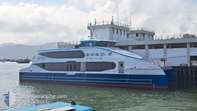
XIN MING ZHU XXX
High speed craft
Current Trip
| Trip Time | 4 days |
|---|---|
| Trip Distance | 403.09 nm |
| AVG Speed | 12.5 Knots |
| MAX Speed | 15.2 Knots |
| Dybgang | 1.6 m |
| AVG Wind | 11.9 knots |
| MAX Wind | 19 knots |
| MIN Temp | 12.8°C / 55.04°F |
| MAX Temp | 19.8°C / 67.64°F |
| Position Modtaget | 2 m siden |
Current Position
| Longitude | 114.14560° |
|---|---|
| Latitude | 22.32817° |
| Status | Under way using engine |
| Fart | 0.1 Knots |
| Kurs | 25° |
| Område | South China Sea |
| Station | T-AIS |
| Position Modtaget | 2 m siden |
Info
Information
The current position of XIN MING ZHU XXX is in South China Sea with coordinates 22.32817° / 114.14560° as reported on 2026-01-04 11:34 by AIS to our vessel tracker app. The vessel's current speed is 0.1 Knots and is currently inside the port of HONG KONG.
The vessel XIN MING ZHU XXX (IMO: 1034917, MMSI: 477997113) is a High speed craft It's sailing under the flag of [HK] Hong Kong.
In this page you can find informations about the vessels current position, last detected port calls, and current voyage information. If the vessels is not in coverage by AIS you will find the latest position.
The current position of XIN MING ZHU XXX is detected by our AIS receivers and we are not responsible for the reliability of the data. The last position was recorded while the vessel was in Coverage by the Ais receivers of our vessel tracking app.
The current draught of XIN MING ZHU XXX as reported by AIS is 1.6 meters
Weather
| Temperature | 17.6°C / 63.68°F |
|---|---|
| Wind Speed | 4 knots |
| Direction | 97° E |
| Pressure | 1020.6 hPa |
| Humidity | 70.4 % |
| Cloud Coverage | 13 % |
Featured Company
Last Port Calls
| Port | Arrival | Departure | Time In Port |
|---|---|---|---|
| 2026-01-03 20:46 | |||
| 2025-12-30 11:32 | 2025-12-30 15:56 | 4 h | |
| 2025-12-12 10:07 | 2025-12-12 17:47 | 7 h | |
| 2025-12-03 11:37 | 2025-12-03 15:50 | 4 h | |
| 2025-11-24 15:51 | 2025-11-26 16:56 | 2 d | |
| 2025-11-06 11:36 | 2025-11-24 15:40 | 18 d |
Most Visited Ports (Last year)
| Port | Arrivals | |
|---|---|---|
| 281 |
Last Trips
| Origin | Departure | Destination | Arrival | Distance | |
|---|---|---|---|---|---|
| 2025-12-30 15:56 | 2026-01-03 20:46 | 403.09 nm | |||
| 2025-12-12 17:47 | 2025-12-30 11:32 | 1667.94 nm | |||
| 2025-12-03 15:50 | 2025-12-12 10:07 | 787.81 nm | |||
| 2025-11-26 16:56 | 2025-12-03 11:37 | 683.60 nm | |||
| 2025-11-24 15:40 | 2025-11-24 15:51 | 2.91 nm | |||
| 2025-10-30 15:32 | 2025-11-06 11:36 | 687.06 nm |
Events
| Tid | Hændelsen | Detaljer | Position / Dest | Info |
|---|---|---|---|---|
| 2026-01-03 12:56 | STOP Sejllads |
22.32813 / 114.14557
[HK] HONG KONG
|
Fart: 0.1 kn Kurs: 26° |
|
| 2026-01-03 12:46 | Skibe i havn |
|
22.31094 / 114.14200
[HK] HONG KONG
|
Fart: 11.1 kn Kurs: 34.4° |
| 2026-01-03 12:26 | Status er ændret | Under way using engine Default |
22.27906 / 114.07318
NANSHA
|
Fart: 13.4 kn Kurs: 82° |
| 2026-01-03 12:21 | Status er ændret | Default Under way using engine |
22.27255 / 114.05463
NANSHA
|
Fart: 12.4 kn Kurs: 60.2° |
| 2026-01-03 12:15 | Status er ændret | Under way using engine Default |
22.26528 / 114.03551
NANSHA
|
Fart: 13.1 kn Kurs: 44° |
| 2026-01-03 12:13 | START Sejllads | 5.48 nm, South East of CHEK LAP KOK |
22.26020 / 114.02621
NANSHA
|
Fart: 13.1 kn Kurs: 44° |
| 2026-01-03 12:05 | Indenfor Dækning |
22.26528 / 114.03551
South China Sea
|
Fart: 12.4 kn Kurs: 60.2° |
|
| 2026-01-03 08:59 | STOP Sejllads | 6.19 nm, South East of CHEK LAP KOK |
22.24425 / 114.02988
NANSHA
|
Fart: 0.1 kn Kurs: 318° |
| 2026-01-03 08:13 | Status er ændret | Default Under way using engine |
22.23958 / 114.00071
NANSHA
|
Fart: 13.5 kn Kurs: 145.3° |
| 2026-01-03 08:05 | Udenfor Dækning |
22.25957 / 114.00974
South China Sea
|
Fart: 13.5 kn Kurs: 145.3° |