
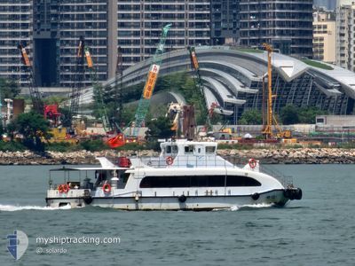
YUE LONG 1
Passenger
Current Trip
| Time Travelled | 12 h, 8 mins |
|---|---|
| Remaining Time | 10 h, 58 mins |
| Distance Travelled | 17.88 nm |
| Remaining Distance | --- |
| AVG Speed | 11.3 Knots |
| MAX Speed | 12.6 Knots |
| AVG Wind | 13.2 knots |
| MAX Wind | 14 knots |
| MIN Temp | 12.3°C / 54.14°F |
| MAX Temp | 19.1°C / 66.38°F |
| Dybgang | 0 m |
| Position Modtaget | 2 h, 4 m siden |
Current Position
| Longitude | 114.08314° |
|---|---|
| Latitude | 22.24243° |
| Status | Default |
| Fart | 11.8 Knots |
| Kurs | 258.3° |
| Område | South China Sea |
| Station | T-AIS |
| Position Modtaget | 2 h, 4 m siden |
Info
Information
The current position of YUE LONG 1 is in South China Sea with coordinates 22.24243° / 114.08314° as reported on 2026-01-05 22:40 by AIS to our vessel tracker app. The vessel's current speed is 11.8 Knots and is heading at the port of HONG KONG. The estimated time of arrival as calculated by MyShipTracking vessel tracking app is 2026-01-06 11:42 LT
The vessel YUE LONG 1 (IMO: 123456789, MMSI: 477996829) is a Passenger It's sailing under the flag of [HK] Hong Kong.
In this page you can find informations about the vessels current position, last detected port calls, and current voyage information. If the vessels is not in coverage by AIS you will find the latest position.
The current position of YUE LONG 1 is detected by our AIS receivers and we are not responsible for the reliability of the data. The last position was recorded while the vessel was in Coverage by the Ais receivers of our vessel tracking app.
Weather
| Temperature | 12.3°C / 54.14°F |
|---|---|
| Wind Speed | 14 knots |
| Direction | 6° N |
| Pressure | 1024.9 hPa |
| Humidity | 65.9 % |
| Cloud Coverage | 2 % |
Featured Company
Last Port Calls
| Port | Arrival | Departure | Time In Port |
|---|---|---|---|
| 2026-01-05 12:12 | 2026-01-05 12:36 | 23 m | |
| 2026-01-04 12:16 | 2026-01-04 12:39 | 23 m | |
| 2026-01-01 12:19 | 2026-01-01 12:39 | 20 m | |
| 2025-12-28 12:16 | 2025-12-28 12:40 | 24 m | |
| 2025-12-26 12:20 | 2025-12-26 12:48 | 27 m | |
| 2025-12-25 12:21 | 2025-12-25 12:46 | 24 m | |
| 2025-12-23 12:14 | 2025-12-23 12:42 | 28 m | |
| 2025-12-22 12:12 | 2025-12-22 12:35 | 22 m | |
| 2025-12-21 13:12 | 2025-12-21 13:35 | 22 m | |
| 2025-12-20 12:06 | 2025-12-20 12:35 | 29 m |
Most Visited Ports (Last year)
| Port | Arrivals | |
|---|---|---|
| 292 |
Last Trips
| Origin | Departure | Destination | Arrival | Distance | |
|---|---|---|---|---|---|
| 2026-01-04 20:39 | 2026-01-05 20:12 | 44.46 nm | |||
| 2026-01-01 20:39 | 2026-01-04 20:16 | 98.35 nm | |||
| 2025-12-28 20:40 | 2026-01-01 20:19 | 130.94 nm | |||
| 2025-12-26 20:48 | 2025-12-28 20:16 | 68.27 nm | |||
| 2025-12-25 20:46 | 2025-12-26 20:20 | 43.99 nm | |||
| 2025-12-23 20:42 | 2025-12-25 20:21 | 72.74 nm | |||
| 2025-12-22 20:35 | 2025-12-23 20:14 | 42.59 nm | |||
| 2025-12-21 21:35 | 2025-12-22 20:12 | 44.45 nm | |||
| 2025-12-20 20:35 | 2025-12-21 21:12 | 44.46 nm | |||
| 2025-12-19 20:39 | 2025-12-20 20:06 | 40.91 nm |
Events
| Tid | Hændelsen | Detaljer | Position / Dest | Info |
|---|---|---|---|---|
| 2026-01-05 23:48 | START Sejllads | 6.26 nm, North West of WAILINGDING ISLAND |
22.19779 / 113.97842
|
Fart: 11.7 kn Kurs: 356° |
| 2026-01-05 23:43 | STOP Sejllads | 5.72 nm, North of WAILINGDING ISLAND |
22.19025 / 113.98402
|
Fart: 0.1 kn Kurs: -1° |
| 2026-01-05 22:40 | Udenfor Dækning |
22.24243 / 114.08314
South China Sea
|
Fart: 11.8 kn Kurs: 258.3° |
|
| 2026-01-05 22:29 | Indenfor Dækning |
22.24243 / 114.08314
South China Sea
|
Fart: 11.8 kn Kurs: 258.3° |
|
| 2026-01-05 12:48 | Udenfor Dækning |
22.27651 / 114.11318
South China Sea
|
Fart: 11.3 kn Kurs: 147.3° |
|
| 2026-01-05 12:36 | Afsejlet fra sidste havn |
|
22.31272 / 114.10867
|
Fart: 11.5 kn Kurs: 206.9° |
| 2026-01-05 12:12 | Skibe i havn |
|
22.36518 / 114.10004
[HK] HONG KONG
|
Fart: 12.4 kn Kurs: 21° |
| 2026-01-05 11:28 | Indenfor Dækning |
22.27822 / 114.04830
South China Sea
|
Fart: 11.7 kn Kurs: 43.1° |
|
| 2026-01-05 11:05 | START Sejllads | 6.15 nm, North West of WAILINGDING ISLAND |
22.19570 / 113.97797
|
Fart: 11.7 kn Kurs: 318° |
| 2026-01-05 10:56 | STOP Sejllads | 5.62 nm, North West of WAILINGDING ISLAND |
22.18846 / 113.98399
|
Fart: 0.1 kn Kurs: -1° |