
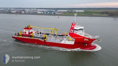
TEUNIS HUIBERTUS
Dredging or underwater ops
Current Trip
| Time Travelled | 40 days |
|---|---|
| Remaining Time | 5 h, 12 mins |
| Distance Travelled | 4018.21 nm |
| Remaining Distance | 47.96 nm |
| AVG Speed | 8.7 Knoten |
| MAX Speed | 16.8 Knoten |
| AVG Wind | 11.4 knots |
| MAX Wind | 38 knots |
| MIN Temp | -1.4°C / 29.48°F |
| MAX Temp | 10.9°C / 51.62°F |
| Tiefgang | 6.8 m |
| Position erhalten | Jetzt |
Current Position
| Länge | 7.04048° |
|---|---|
| Breite | 53.32403° |
| Zustand | Restricted manoeuverability |
| Geschwindigkeit | 2.8 Knoten |
| Kurs | 90° |
| Gebiet | North Sea |
| Station | T-AIS |
| Position erhalten | Jetzt |
Info
Information
Die aktuelle Position von TEUNIS HUIBERTUS befindet sich in North Sea mit den Koordinaten 53.32403° / 7.04048°, wie von AIS am 2025-02-11 23:53 an unsere Schiffsverfolgungs-App. Die aktuelle Geschwindigkeit des Schiffes betragt 2.8 Knoten und fahrt in den Hafen von HAREN. Die geschatzte Ankunftszeit, berechnet von der MyShipTracking-App zur Schiffsverfolgung, ist 2025-02-12 05:06 LT
Das Schiff TEUNIS HUIBERTUS (IMO: 9924156, MMSI: 246849000) ist Dredging or underwater ops Es segelt unter der Flagge [NL] Netherlands.
Auf dieser Seite finden Sie Informationen zur aktuellen Position des Schiffes, zu den zuletzt erkannten Hafenanlaufen und zu aktuellen Reiseinformationen. Wenn die Schiffe nicht von AIS abgedeckt werden, finden Sie die neueste Position.
Die aktuelle Position von TEUNIS HUIBERTUS wird von unseren AIS-Empfangern erkannt und wir sind nicht fur die Zuverlassigkeit der Daten verantwortlich. Die letzte Position wurde von den Ais-Empfangern unserer Schiffsverfolgungs-App aufgezeichnet, wahrend sich das Schiff in Deckung befand.
Der aktuelle Entwurf von TEUNIS HUIBERTUS, wie von AIS gemeldet, betragt 6.8 meter
Weather
| Temperature | 0.8°C / 33.44°F |
|---|---|
| Wind Speed | 10 knots |
| Direction | 95° E |
| Pressure | 1021 hPa |
| Humidity | 91.5 % |
| Cloud Coverage | 100 % |
Featured Company
Most Visited Ports (Last year)
| Port | Arrivals | |
|---|---|---|
| 9 | ||
| 5 | ||
| 1 | ||
| 1 | ||
| 1 |
Events
| Zeit | Ereignis | Details | Position / Ziel | Information |
|---|---|---|---|---|
| 2025-02-11 23:46 | Ändere Seegebiet | German part of the North Sea Dutch part of the North Sea |
53.32372 / 7.02123
North Sea
|
Geschwindigkeit: 9.4 kn Kurs: 93.8° |
| 2025-02-11 23:04 | START Bewegung | 4.12 nm, South East of EEMSHAVEN |
53.42209 / 6.94023
EMS DREDGING
|
Geschwindigkeit: 7.8 kn Kurs: 185.7° |
| 2025-02-11 23:01 | STOP Bewegung | 4.1 nm, South East of EEMSHAVEN |
53.42401 / 6.94109
EMS DREDGING
|
Geschwindigkeit: 0.2 kn Kurs: 234° |
| 2025-02-11 22:19 | Ändere Seegebiet | Dutch part of the North Sea German part of the North Sea |
53.33273 / 7.00231
North Sea
|
Geschwindigkeit: 8.9 kn Kurs: 311.8° |
| 2025-02-11 21:22 | Ändere Seegebiet | German part of the North Sea Dutch part of the North Sea |
53.32359 / 7.02592
North Sea
|
Geschwindigkeit: 8.2 kn Kurs: 90.8° |
| 2025-02-11 19:43 | Ändere Seegebiet | Dutch part of the North Sea German part of the North Sea |
53.32987 / 7.01109
North Sea
|
Geschwindigkeit: 7.9 kn Kurs: 298.5° |
| 2025-02-11 18:43 | Ändere Seegebiet | German part of the North Sea Dutch part of the North Sea |
53.32847 / 7.01827
North Sea
|
Geschwindigkeit: 11 kn Kurs: 110.9° |
| 2025-02-11 17:10 | Ändere Seegebiet | Dutch part of the North Sea German part of the North Sea |
53.32368 / 7.02004
North Sea
|
Geschwindigkeit: 7.8 kn Kurs: 276.7° |
| 2025-02-11 16:10 | Ändere Seegebiet | German part of the North Sea Dutch part of the North Sea |
53.32860 / 7.01659
North Sea
|
Geschwindigkeit: 10 kn Kurs: 108° |
| 2025-02-11 15:33 | START Bewegung | 4.31 nm, South East of EEMSHAVEN |
53.42111 / 6.94537
EMS DREDGING
|
Geschwindigkeit: 4.5 kn Kurs: 171° |