

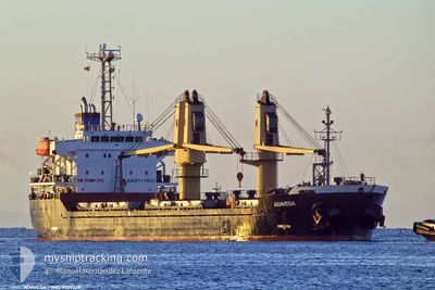
ADAVEGA
Bulk Carrier

Current Trip
| Time Travelled | 8 days |
|---|---|
| Remaining Time | --- |
| Distance Travelled | 949.66 nm |
| Remaining Distance | --- |
| AVG Speed | 10.5 Noeuds |
| MAX Speed | 13.3 Noeuds |
| AVG Wind | 6 knots |
| MAX Wind | 22 knots |
| MIN Temp | 13.7°C / 56.66°F |
| MAX Temp | 25.1°C / 77.18°F |
| Tirant d eau | 5.2 m |
| Position reçue | 7 d depuis |
Current Position
| Longitude | 31.57203° |
|---|---|
| Latitude | 41.61976° |
| Etat | Under way using engine |
| Vitesse | 12.7 Noeuds |
| Parcours | 59.6° |
| Zone | Black Sea |
| Station | T-AIS |
| Position reçue | 7 d depuis |
Information
The current position of ADAVEGA is in Black Sea with coordinates 41.61976° / 31.57203° as reported on 2025-05-25 03:05 by AIS to our vessel tracker app. The vessel's current speed is 12.7 Noeuds
The vessel ADAVEGA (IMO: 9539339, MMSI: 636019710) is a Bulk Carrier that was built in 2010 ( 15 Age ). It's sailing under the flag of [LR] Liberia.
In this page you can find informations about the vessels current position, last detected port calls, and current voyage information. If the vessels is not in coverage by AIS you will find the latest position.
The current position of ADAVEGA is detected by our AIS receivers and we are not responsible for the reliability of the data. The last position was recorded while the vessel was in Coverage by the Ais receivers of our vessel tracking app.
The current draught of ADAVEGA as reported by AIS is 5.2 meters
Weather
| Temperature | 16.1°C / 60.98°F |
|---|---|
| Wind Speed | 2 knots |
| Direction | 29° NNE |
| Pressure | 1016.7 hPa |
| Humidity | 67.7 % |
| Cloud Coverage | 15 % |


Featured Company
Last Trips
| Origin | Departure | Destination | Arrival | Distance | |
|---|---|---|---|---|---|
| 2025-05-14 18:39 | 2025-05-21 19:29 | 1419.45 nm | |||
| 2025-04-11 09:42 | 2025-04-23 07:58 | 3169.28 nm | |||
| 2025-04-05 12:32 | 2025-04-07 07:45 | 412.08 nm | |||
| 2025-04-04 14:32 | 2025-04-05 12:29 | 151.35 nm | |||
| 2025-03-26 13:10 | 2025-04-02 20:11 | 1716.89 nm |
Events
| Heure | Evenement | Détails | Position/ Destination | Info |
|---|---|---|---|---|
| 2025-05-31 04:58 | Démarrage | 8.09 nm, North East of TRABZON |
41.11615 / 39.84887
GEPTI
|
Vitesse: 3.4 kn Parcours: 273° |
| 2025-05-26 07:37 | Arret |
42.22902 / 39.19046
GEPTI
|
Vitesse: 0.2 kn Parcours: 177° |
|
| 2025-05-25 03:10 | Etat Changé | Default Under way using engine |
41.62948 / 31.59413
GEPTI
|
Vitesse: 12.7 kn Parcours: 59.6° |
| 2025-05-25 03:05 | Hors de la zone couverte |
41.61976 / 31.57203
Black Sea
GEPTI
|
Vitesse: 12.7 kn Parcours: 59.6° |
|
| 2025-05-25 03:05 | Etat Changé | Under way using engine Default |
41.61922 / 31.57080
GEPTI
|
Vitesse: 12.7 kn Parcours: 60° |
| 2025-05-25 02:39 | Etat Changé | Default Under way using engine |
41.57507 / 31.46759
GEPTI
|
Vitesse: 12.7 kn Parcours: 60.8° |
| 2025-05-25 02:16 | Etat Changé | Under way using engine Default |
41.53467 / 31.37061
GEPTI
|
Vitesse: 12.6 kn Parcours: 60° |
| 2025-05-25 02:11 | Dans la zone couverte |
41.53542 / 31.37238
Black Sea
GEPTI
|
Vitesse: 12.6 kn Parcours: 60.6° |
|
| 2025-05-25 01:14 | Etat Changé | Default Under way using engine |
41.49877 / 31.08962
GEPTI
|
Vitesse: 12.8 kn Parcours: 83.6° |
| 2025-05-25 01:09 | Hors de la zone couverte |
41.49672 / 31.06545
Black Sea
GEPTI
|
Vitesse: 12.8 kn Parcours: 83.6° |