
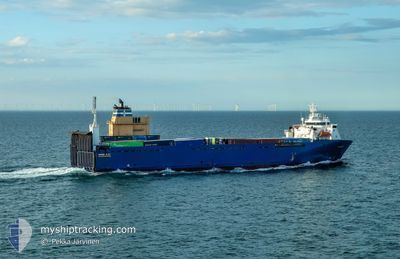
BORE BAY
Vehicles Carrier
Current Trip
| Time Travelled | 8 h, 4 mins |
|---|---|
| Remaining Time | 6 h, 54 mins |
| Distance Travelled | 105.76 nm |
| Remaining Distance | 96.42 nm |
| AVG Speed | 13.5 Noeuds |
| MAX Speed | 16.4 Noeuds |
| AVG Wind | 16.7 knots |
| MAX Wind | 28 knots |
| MIN Temp | 4.6°C / 40.28°F |
| MAX Temp | 5.3°C / 41.54°F |
| Tirant d eau | 6.1 m |
| Position reçue | Maintenant |
Current Position
| Longitude | 2.02586° |
|---|---|
| Latitude | 52.87622° |
| Etat | Under way using engine |
| Vitesse | 13.3 Noeuds |
| Parcours | 315.9° |
| Zone | North Sea |
| Station | T-AIS |
| Position reçue | Maintenant |
Info
Information
The current position of BORE BAY is in North Sea with coordinates 52.87622° / 2.02586° as reported on 2025-02-07 08:49 by AIS to our vessel tracker app. The vessel's current speed is 13.3 Noeuds and is heading at the port of IMMINGHAM. The estimated time of arrival as calculated by MyShipTracking vessel tracking app is 2025-02-07 15:44 LT
The vessel BORE BAY (IMO: 9122007, MMSI: 230357000) is a Vehicles Carrier that was built in 1997 ( 28 Age ). It's sailing under the flag of [FI] Finland.
In this page you can find informations about the vessels current position, last detected port calls, and current voyage information. If the vessels is not in coverage by AIS you will find the latest position.
The current position of BORE BAY is detected by our AIS receivers and we are not responsible for the reliability of the data. The last position was recorded while the vessel was in Coverage by the Ais receivers of our vessel tracking app.
The current draught of BORE BAY as reported by AIS is 6.1 meters
Weather
| Temperature | 4.3°C / 39.74°F |
|---|---|
| Wind Speed | 26 knots |
| Direction | 85° E |
| Pressure | 1032.8 hPa |
| Humidity | 76 % |
| Cloud Coverage | 100 % |
Featured Company
Last Port Calls
| Port | Arrival | Departure | Time In Port |
|---|---|---|---|
| 2025-02-06 17:57 | 2025-02-07 01:46 | 7 h | |
| 2025-02-05 13:20 | 2025-02-05 15:54 | 2 h | |
| 2025-02-04 15:58 | 2025-02-04 17:25 | 1 h | |
| 2025-02-04 07:49 | 2025-02-04 13:52 | 6 h | |
| 2025-02-03 22:16 | 2025-02-04 07:29 | 9 h | |
| 2025-02-03 16:01 | 2025-02-03 19:15 | 3 h | |
| 2025-02-03 08:35 | 2025-02-03 12:16 | 3 h | |
| 2025-02-03 02:01 | 2025-02-03 02:44 | 42 m | |
| 2025-02-02 19:37 | 2025-02-02 23:43 | 4 h | |
| 2025-01-31 14:12 | 2025-02-01 14:10 | 23 h |
Last Trips
| Origin | Departure | Destination | Arrival | Distance | |
|---|---|---|---|---|---|
| 2025-02-05 15:54 | 2025-02-06 17:57 | 308.30 nm | |||
| 2025-02-04 17:25 | 2025-02-05 13:20 | 265.63 nm | |||
| 2025-02-04 13:52 | 2025-02-04 15:58 | 26.30 nm | |||
| 2025-02-04 07:29 | 2025-02-04 07:49 | 1.35 nm | |||
| 2025-02-03 19:15 | 2025-02-03 22:16 | 40.98 nm | |||
| 2025-02-03 12:16 | 2025-02-03 16:01 | 50.30 nm | |||
| 2025-02-03 02:44 | 2025-02-03 08:35 | 76.98 nm | |||
| 2025-02-02 23:43 | 2025-02-03 02:01 | 27.07 nm | |||
| 2025-02-01 14:10 | 2025-02-02 19:37 | 387.93 nm | |||
| 2025-01-30 23:54 | 2025-01-31 14:12 | 201.36 nm |
Events
| Heure | Evenement | Détails | Position/ Destination | Info |
|---|---|---|---|---|
| 2025-02-07 08:18 | Etat Changé | Under way using engine Default |
52.79603 / 2.16230
GBIMM
|
Vitesse: 13.5 kn Parcours: 316° |
| 2025-02-07 08:17 | Etat Changé | Default Under way using engine |
52.79343 / 2.16671
GBIMM
|
Vitesse: 13.9 kn Parcours: 312.5° |
| 2025-02-07 08:09 | Changement de zone | United Kingdom part of the North Sea Dutch part of the North Sea |
52.77135 / 2.20371
North Sea
GBIMM
|
Vitesse: 13.9 kn Parcours: 312.5° |
| 2025-02-07 08:09 | Etat Changé | Under way using engine Default |
52.77135 / 2.20371
GBIMM
|
Vitesse: 13.9 kn Parcours: 315° |
| 2025-02-07 08:01 | Dans la zone couverte |
52.77135 / 2.20371
North Sea
GBIMM
|
Vitesse: 13.9 kn Parcours: 312.5° |
|
| 2025-02-07 03:11 | Etat Changé | Default Under way using engine |
52.10504 / 3.64218
GBIMM
|
Vitesse: 13.3 kn Parcours: 290.8° |
| 2025-02-07 03:03 | Hors de la zone couverte |
52.09296 / 3.69027
North Sea
GBIMM
|
Vitesse: 13.3 kn Parcours: 290.8° |
|
| 2025-02-07 00:46 | PORT DE DEPART |
|
51.89475 / 4.39670
GBIMM
|
Vitesse: 7.7 kn Parcours: 314° |
| 2025-02-07 00:40 | Etat Changé | Under way using engine Moored |
51.88459 / 4.40667
[NL] ROTTERDAM PERNIS
|
Vitesse: 5.9 kn Parcours: 337° |
| 2025-02-07 00:40 | Démarrage |
51.88436 / 4.40685
[NL] ROTTERDAM PERNIS
|
Vitesse: 5.9 kn Parcours: 337° |