

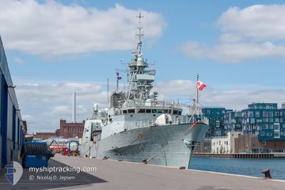
CANADIAN WARSHIP 340
Military ops

Current Trip
MILITARY OPS
| Time Travelled | 1 day |
|---|---|
| Remaining Time | --- |
| Distance Travelled | 158.95 nm |
| Remaining Distance | --- |
| AVG Speed | 9 Noeuds |
| MAX Speed | 9 Noeuds |
| AVG Wind | 9.8 knots |
| MAX Wind | 14 knots |
| MIN Temp | 8.4°C / 47.12°F |
| MAX Temp | 16.9°C / 62.42°F |
| Tirant d eau | 7.3 m |
| Position reçue | 13 h, 30 m depuis |
Current Position
| Longitude | -63.17776° |
|---|---|
| Latitude | 44.16409° |
| Etat | Under way using engine |
| Vitesse | 16.2 Noeuds |
| Parcours | 138.5° |
| Zone | North Atlantic Ocean |
| Station | T-AIS |
| Position reçue | 13 h, 30 m depuis |
Information
The current position of CANADIAN WARSHIP 340 is in North Atlantic Ocean with coordinates 44.16409° / -63.17776° as reported on 2025-06-09 21:55 by AIS to our vessel tracker app. The vessel's current speed is 16.2 Noeuds
The vessel CANADIAN WARSHIP 340 (MMSI: 316196000) is a Military ops It's sailing under the flag of [CA] Canada.
In this page you can find informations about the vessels current position, last detected port calls, and current voyage information. If the vessels is not in coverage by AIS you will find the latest position.
The current position of CANADIAN WARSHIP 340 is detected by our AIS receivers and we are not responsible for the reliability of the data. The last position was recorded while the vessel was in Coverage by the Ais receivers of our vessel tracking app.
The current draught of CANADIAN WARSHIP 340 as reported by AIS is 7.3 meters
Weather
| Temperature | 11.2°C / 52.16°F |
|---|---|
| Wind Speed | 10 knots |
| Direction | 93° E |
| Pressure | 1020.7 hPa |
| Humidity | 80.1 % |
| Cloud Coverage | 77 % |


Featured Company
Last Port Calls
| Port | Arrival | Departure | Time In Port |
|---|---|---|---|
| 2025-04-29 16:31 | 2025-06-08 11:13 | ||
| 2025-04-25 14:18 | 2025-04-28 09:24 | 2 d | |
| 2025-04-24 08:21 | 2025-04-24 09:19 | 58 m | |
| 2025-04-23 07:49 | 2025-04-23 08:47 | 58 m | |
| 2025-04-17 07:40 | 2025-04-22 09:41 | 5 d | |
| 2025-04-16 00:35 | 2025-04-16 16:07 | 15 h | |
| 2025-04-16 00:05 | 2025-04-16 00:21 | 16 m | |
| 2025-04-15 23:25 | 2025-04-15 23:50 | 25 m | |
| 2025-04-15 22:49 | 2025-04-15 23:08 | 19 m | |
| 2025-04-15 22:10 | 2025-04-15 22:31 | 20 m |
Last Trips
| Origin | Departure | Destination | Arrival | Distance | |
|---|---|---|---|---|---|
| 2025-04-28 09:24 | 2025-04-29 16:31 | 4.89 nm | |||
| 2025-04-24 09:19 | 2025-04-25 14:18 | 187.93 nm | |||
| 2025-04-23 08:47 | 2025-04-24 08:21 | 42.26 nm | |||
| 2025-04-22 09:41 | 2025-04-23 07:49 | 70.66 nm | |||
| 2025-04-16 16:07 | 2025-04-17 07:40 | 38.31 nm | |||
| 2025-04-16 00:21 | 2025-04-16 00:35 | 3.96 nm | |||
| 2025-04-15 23:50 | 2025-04-16 00:05 | 4.28 nm | |||
| 2025-04-15 23:08 | 2025-04-15 23:25 | 3.42 nm | |||
| 2025-04-15 22:31 | 2025-04-15 22:49 | 4.08 nm | |||
| 2025-04-15 21:50 | 2025-04-15 22:10 | 4.40 nm |
Events
| Heure | Evenement | Détails | Position/ Destination | Info |
|---|---|---|---|---|
| 2025-06-09 21:55 | Hors de la zone couverte |
44.16409 / -63.17776
North Atlantic Ocean
|
Vitesse: 16.2 kn Parcours: 138.5° |
|
| 2025-06-09 21:39 | Dans la zone couverte |
44.18323 / -63.20900
North Atlantic Ocean
|
Vitesse: 14.8 kn Parcours: 329.9° |
|
| 2025-06-09 17:38 | Hors de la zone couverte |
44.15199 / -63.26670
North Atlantic Ocean
|
Vitesse: 21 kn Parcours: 90.2° |
|
| 2025-06-09 17:33 | Dans la zone couverte |
44.15210 / -63.29098
North Atlantic Ocean
|
Vitesse: 20.9 kn Parcours: 89.2° |
|
| 2025-06-09 09:37 | Hors de la zone couverte |
44.21286 / -63.33668
North Atlantic Ocean
|
Vitesse: 4.3 kn Parcours: 109.2° |
|
| 2025-06-09 08:32 | Dans la zone couverte |
44.22388 / -63.40903
North Atlantic Ocean
|
Vitesse: 13.8 kn Parcours: 277.7° |
|
| 2025-06-09 06:58 | Hors de la zone couverte |
44.23612 / -63.31788
North Atlantic Ocean
|
Vitesse: 5.2 kn Parcours: 94.6° |
|
| 2025-06-09 06:22 | Dans la zone couverte |
44.23891 / -63.39940
North Atlantic Ocean
|
Vitesse: 6 kn Parcours: 104.6° |
|
| 2025-06-09 05:03 | Hors de la zone couverte |
44.32937 / -63.43761
North Atlantic Ocean
|
Vitesse: 4.3 kn Parcours: 161.5° |
|
| 2025-06-08 19:52 | Etat Changé | Under way using engine Restricted manoeuverability |
44.53902 / -63.38562
MILITARY OPS
|
Vitesse: 7.9 kn Parcours: 344.2° |