
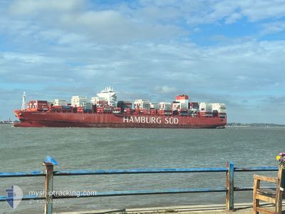
CAP SAN LAZARO
Cargo
Current Trip
| Time Travelled | 19 days |
|---|---|
| Remaining Time | 2 days |
| Distance Travelled | 8790.57 nm |
| Remaining Distance | 1145.90 nm |
| AVG Speed | 18.6 Noeuds |
| MAX Speed | 22.1 Noeuds |
| AVG Wind | 11 knots |
| MAX Wind | 23 knots |
| MIN Temp | 18.5°C / 65.3°F |
| MAX Temp | 29.2°C / 84.56°F |
| Tirant d eau | 12.6 m |
| Position reçue | 7 d depuis |
Current Position
| Longitude | 12.98648° |
|---|---|
| Latitude | -28.54503° |
| Etat | Under way using engine |
| Vitesse | 18.8 Noeuds |
| Parcours | 324° |
| Zone | South Atlantic Ocean |
| Station | T-AIS |
| Position reçue | 7 d depuis |
Info
Information
The current position of CAP SAN LAZARO is in South Atlantic Ocean with coordinates -28.54503° / 12.98648° as reported on 2025-03-07 03:36 by AIS to our vessel tracker app. The vessel's current speed is 18.8 Noeuds and is heading at the port of ALGECIRAS. The estimated time of arrival as calculated by MyShipTracking vessel tracking app is 2025-03-17 20:01 LT
The vessel CAP SAN LAZARO (IMO: 9717216, MMSI: 538008134) is a Cargo It's sailing under the flag of [MH] Marshall Is.
In this page you can find informations about the vessels current position, last detected port calls, and current voyage information. If the vessels is not in coverage by AIS you will find the latest position.
The current position of CAP SAN LAZARO is detected by our AIS receivers and we are not responsible for the reliability of the data. The last position was recorded while the vessel was in Coverage by the Ais receivers of our vessel tracking app.
The current draught of CAP SAN LAZARO as reported by AIS is 12.6 meters
Weather
| Temperature | 18.6°C / 65.48°F |
|---|---|
| Wind Speed | 16 knots |
| Direction | 22° NNE |
| Pressure | 1016.4 hPa |
| Humidity | 85.5 % |
| Cloud Coverage | --- |
Featured Company
Last Port Calls
| Port | Arrival | Departure | Time In Port |
|---|---|---|---|
| 2025-02-21 11:13 | 2025-02-23 10:53 | 1 d | |
| 2025-02-15 10:01 | 2025-02-17 19:29 | 2 d | |
| 2025-02-12 04:57 | 2025-02-12 20:41 | 15 h | |
| 2025-02-06 03:53 | 2025-02-06 22:00 | 18 h | |
| 2025-02-02 08:00 | 2025-02-03 07:10 | 23 h | |
| 2025-01-09 08:55 | 2025-01-10 05:05 | 20 h | |
| 2025-01-03 15:32 |
Most Visited Ports (Last year)
| Port | Arrivals | |
|---|---|---|
| 5 | ||
| 4 | ||
| 4 | ||
| 4 | ||
| 4 | ||
| 3 |
Last Trips
| Origin | Departure | Destination | Arrival | Distance | |
|---|---|---|---|---|---|
| 2025-02-18 00:59 | 2025-02-21 16:43 | 709.72 nm | |||
| 2025-02-13 02:11 | 2025-02-15 15:31 | 749.13 nm | |||
| 2025-02-07 02:00 | 2025-02-12 10:27 | 1971.04 nm | |||
| 2025-02-03 11:10 | 2025-02-06 07:53 | 1008.12 nm | |||
| 2025-01-10 06:05 | 2025-02-02 12:00 | 9437.29 nm | |||
| 2025-01-03 15:32 | 2025-01-09 09:55 | 1588.97 nm |
Events
| Heure | Evenement | Détails | Position/ Destination | Info |
|---|---|---|---|---|
| 2025-03-07 03:42 | Etat Changé | Default Under way using engine |
-28.51962 / 12.96448
ESALG
|
Vitesse: 18.8 kn Parcours: 324° |
| 2025-03-07 03:36 | Changement de zone | Namibian part of the South Atlantic Ocean South African part of the South Atlantic Ocean |
-28.54503 / 12.98648
South Atlantic Ocean
ESALG
|
Vitesse: 18.8 kn Parcours: 324° |
| 2025-03-07 03:36 | Etat Changé | Under way using engine Default |
-28.54503 / 12.98648
ESALG
|
Vitesse: 19 kn Parcours: 323° |
| 2025-03-07 03:36 | Hors de la zone couverte |
-28.54503 / 12.98648
South Atlantic Ocean
ESALG
|
Vitesse: 18.8 kn Parcours: 324° |
|
| 2025-03-07 03:23 | Dans la zone couverte |
-28.54503 / 12.98648
South Atlantic Ocean
ESALG
|
Vitesse: 18.8 kn Parcours: 324° |
|
| 2025-03-06 05:43 | Etat Changé | Default Under way using engine |
-34.19058 / 17.92665
ESALG
|
Vitesse: 18.3 kn Parcours: 327° |
| 2025-03-06 05:39 | Etat Changé | Under way using engine Default |
-34.20600 / 17.93895
ESALG
|
Vitesse: 18.4 kn Parcours: 325° |
| 2025-03-06 05:39 | Hors de la zone couverte |
-34.20600 / 17.93895
South Atlantic Ocean
ESALG
|
Vitesse: 18.3 kn Parcours: 327° |
|
| 2025-03-06 05:31 | Etat Changé | Default Under way using engine |
-34.23845 / 17.96472
ESALG
|
Vitesse: 18.3 kn Parcours: 325.3° |
| 2025-03-06 04:49 | Etat Changé | Under way using engine Default |
-34.39995 / 18.13140
ESALG
|
Vitesse: 18.5 kn Parcours: 311° |