
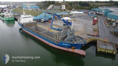
CLARA K
General Cargo
Current Trip
| Trip Time | 4 days |
|---|---|
| Trip Distance | 1004.66 nm |
| AVG Speed | 9 Noeuds |
| MAX Speed | 13.8 Noeuds |
| Tirant d eau | 5.4 m |
| AVG Wind | 13.6 knots |
| MAX Wind | 34 knots |
| MIN Temp | 3.2°C / 37.76°F |
| MAX Temp | 12.3°C / 54.14°F |
| Position reçue | 7 m depuis |
Current Position
| Longitude | -8.72336° |
|---|---|
| Latitude | 40.64340° |
| Etat | Moored |
| Vitesse | |
| Parcours | 243° |
| Zone | North Atlantic Ocean |
| Station | T-AIS |
| Position reçue | 7 m depuis |
Info
Information
The current position of CLARA K is in North Atlantic Ocean with coordinates 40.64340° / -8.72336° as reported on 2025-02-08 20:49 by AIS to our vessel tracker app. The vessel's current speed is 0 Noeuds and is currently inside the port of AVEIRO.
The vessel CLARA K (IMO: 9373321, MMSI: 244424000) is a General Cargo that was built in 2007 ( 18 Age ). It's sailing under the flag of [NL] Netherlands.
In this page you can find informations about the vessels current position, last detected port calls, and current voyage information. If the vessels is not in coverage by AIS you will find the latest position.
The current position of CLARA K is detected by our AIS receivers and we are not responsible for the reliability of the data. The last position was recorded while the vessel was in Coverage by the Ais receivers of our vessel tracking app.
The current draught of CLARA K as reported by AIS is 5.4 meters
Weather
| Temperature | 12.6°C / 54.68°F |
|---|---|
| Wind Speed | 6 knots |
| Direction | 162° SSE |
| Pressure | 1025.5 hPa |
| Humidity | 72.3 % |
| Cloud Coverage | 99 % |
Featured Company
Last Port Calls
| Port | Arrival | Departure | Time In Port |
|---|---|---|---|
| 2025-02-08 16:00 | |||
| 2025-02-02 19:56 | 2025-02-03 21:57 | 1 d | |
| 2025-01-26 17:16 | 2025-01-31 11:12 | 4 d | |
| 2025-01-22 07:50 | 2025-01-24 05:23 | 1 d | |
| 2025-01-20 13:00 | 2025-01-21 23:55 | 1 d | |
| 2025-01-09 17:59 | 2025-01-10 19:31 | 1 d | |
| 2024-12-29 09:14 | 2025-01-02 10:57 | 4 d | |
| 2024-12-20 06:53 | 2024-12-23 17:12 | 3 d | |
| 2024-12-16 19:24 | 2024-12-17 16:48 | 21 h | |
| 2024-12-12 18:03 | 2024-12-14 16:40 | 1 d |
Last Trips
| Origin | Departure | Destination | Arrival | Distance | |
|---|---|---|---|---|---|
| 2025-02-03 22:57 | 2025-02-08 16:00 | 1004.66 nm | |||
| 2025-01-31 11:12 | 2025-02-02 20:56 | 137.47 nm | |||
| 2025-01-24 06:23 | 2025-01-26 17:16 | 570.30 nm | |||
| 2025-01-22 00:55 | 2025-01-22 08:50 | 77.42 nm | |||
| 2025-01-10 20:31 | 2025-01-20 14:00 | 1406.60 nm | |||
| 2025-01-02 10:57 | 2025-01-09 18:59 | 185.26 nm | |||
| 2024-12-23 18:12 | 2024-12-29 09:14 | 642.10 nm | |||
| 2024-12-17 17:48 | 2024-12-20 07:53 | 512.10 nm | |||
| 2024-12-14 16:40 | 2024-12-16 20:24 | 276.52 nm | |||
| 2024-12-02 20:33 | 2024-12-12 18:03 | 685.90 nm |
Events
| Heure | Evenement | Détails | Position/ Destination | Info |
|---|---|---|---|---|
| 2025-02-08 16:37 | Etat Changé | Moored Under way using engine |
40.64341 / -8.72335
[PT] AVEIRO
|
Vitesse: Parcours: 241° |
| 2025-02-08 16:25 | Arret |
40.64366 / -8.72345
[PT] AVEIRO
|
Vitesse: 0.3 kn Parcours: 235° |
|
| 2025-02-08 16:00 | Port d'arrivée |
|
40.64393 / -8.75825
[PT] AVEIRO
|
Vitesse: 9.2 kn Parcours: 54.4° |
| 2025-02-08 10:16 | Changement d'ETA | 2025/02/08 15:00 2025/02/08 07:00 |
41.27176 / -9.16340
PT AVE
|
Vitesse: 6.1 kn Parcours: 157.7° |
| 2025-02-08 09:55 | Etat Changé | Under way using engine Default |
41.30592 / -9.18129
PT AVE
|
Vitesse: 6.4 kn Parcours: 159° |
| 2025-02-08 09:51 | Etat Changé | Default Under way using engine |
41.31271 / -9.18487
PT AVE
|
Vitesse: 7.1 kn Parcours: 160.3° |
| 2025-02-08 08:31 | Detecté en mer | Portuguese part of the North Atlantic Ocean |
41.45647 / -9.25578
North Atlantic Ocean
PT AVE
|
Vitesse: 7 kn Parcours: 156.2° |
| 2025-02-08 08:31 | Etat Changé | Under way using engine Default |
41.45647 / -9.25578
PT AVE
|
Vitesse: 7.1 kn Parcours: 152° |
| 2025-02-08 08:31 | Dans la zone couverte |
41.45647 / -9.25578
North Atlantic Ocean
PT AVE
|
Vitesse: 7 kn Parcours: 156.2° |
|
| 2025-02-05 15:17 | Hors de la zone couverte |
49.55584 / -4.13281
English Channel
PT AVE
|
Vitesse: 10.2 kn Parcours: 239.1° |