

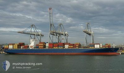
CMA CGM BLUE
Cargo

Current Trip
| Time Travelled | 2 days |
|---|---|
| Remaining Time | --- |
| Distance Travelled | 560.63 nm |
| Remaining Distance | --- |
| AVG Speed | 10.9 Noeuds |
| MAX Speed | 15.1 Noeuds |
| AVG Wind | 12.2 knots |
| MAX Wind | 16.9 knots |
| MIN Temp | 22.4°C / 72.32°F |
| MAX Temp | 26.1°C / 78.98°F |
| Tirant d eau | 8.6 m |
| Position reçue | 1 d depuis |
Current Position
| Longitude | 174.73153° |
|---|---|
| Latitude | -19.10266° |
| Etat | Under way using engine |
| Vitesse | 10.9 Noeuds |
| Parcours | 243.7° |
| Zone | South Pacific Ocean |
| Station | T-AIS |
| Position reçue | 1 d depuis |
Information
The current position of CMA CGM BLUE is in South Pacific Ocean with coordinates -19.10266° / 174.73153° as reported on 2025-06-07 02:32 by AIS to our vessel tracker app. The vessel's current speed is 10.9 Noeuds
The vessel CMA CGM BLUE (IMO: 9756107, MMSI: 249205000) is a Cargo It's sailing under the flag of [MT] Malta.
In this page you can find informations about the vessels current position, last detected port calls, and current voyage information. If the vessels is not in coverage by AIS you will find the latest position.
The current position of CMA CGM BLUE is detected by our AIS receivers and we are not responsible for the reliability of the data. The last position was recorded while the vessel was in Coverage by the Ais receivers of our vessel tracking app.
The current draught of CMA CGM BLUE as reported by AIS is 8.6 meters
Weather
| Temperature | 23.7°C / 74.66°F |
|---|---|
| Wind Speed | 7 knots |
| Direction | 38° NE |
| Pressure | 1015.6 hPa |
| Humidity | 54.1 % |
| Cloud Coverage | 100 % |


Featured Company
Last Port Calls
| Port | Arrival | Departure | Time In Port |
|---|---|---|---|
| 2025-06-05 12:50 | 2025-06-06 21:35 | 1 d | |
| 2025-05-14 06:52 | 2025-05-14 21:00 | 14 h | |
| 2025-05-10 11:12 | 2025-05-11 10:55 | 23 h | |
| 2025-05-07 04:09 | 2025-05-07 05:29 | 1 h | |
| 2025-04-26 22:03 | 2025-04-28 22:00 | 1 d | |
| 2025-04-26 20:58 | 2025-04-26 21:02 | 3 m | |
| 2025-04-24 10:31 | 2025-04-25 19:51 | 1 d | |
| 2025-04-22 11:00 | 2025-04-23 04:51 | 17 h | |
| 2025-04-12 05:46 | 2025-04-12 17:48 | 12 h | |
| 2025-04-09 11:17 | 2025-04-09 22:42 | 11 h |
Most Visited Ports (Last year)
| Port | Arrivals | |
|---|---|---|
| 2 | ||
| 2 | ||
| 2 | ||
| 1 | ||
| 1 | ||
| 1 |
Last Trips
| Origin | Departure | Destination | Arrival | Distance | |
|---|---|---|---|---|---|
| 2025-05-14 21:00 | 2025-06-05 12:50 | 7126.67 nm | |||
| 2025-05-11 10:55 | 2025-05-14 06:52 | 1068.40 nm | |||
| 2025-05-07 05:29 | 2025-05-10 11:12 | 724.01 nm | |||
| 2025-04-28 22:00 | 2025-05-07 04:09 | 3342.65 nm | |||
| 2025-04-26 21:02 | 2025-04-26 22:03 | 8.65 nm | |||
| 2025-04-25 19:51 | 2025-04-26 20:58 | 179.79 nm | |||
| 2025-04-23 04:51 | 2025-04-24 10:31 | 144.88 nm | |||
| 2025-04-12 17:48 | 2025-04-22 11:00 | 3659.10 nm | |||
| 2025-04-09 22:42 | 2025-04-12 05:46 | 701.80 nm | |||
| 2025-04-05 08:20 | 2025-04-09 11:17 | 1523.68 nm |
Events
| Heure | Evenement | Détails | Position/ Destination | Info |
|---|---|---|---|---|
| 2025-06-07 02:36 | Etat Changé | Default Under way using engine |
-19.10723 / 174.72188
FJLTK |
Vitesse: 10.9 kn Parcours: 243.7° |
| 2025-06-07 02:32 | Hors de la zone couverte |
-19.10266 / 174.73153
South Pacific Ocean
FJLTK |
Vitesse: 10.9 kn Parcours: 243.7° |
|
| 2025-06-07 00:32 | Etat Changé | Under way using engine Default |
-18.93958 / 175.07533
FJLTK |
Vitesse: 11.2 kn Parcours: 245° |
| 2025-06-07 00:21 | Dans la zone couverte |
-18.94262 / 175.06893
South Pacific Ocean
FJLTK |
Vitesse: 11.1 kn Parcours: 242.9° |
|
| 2025-06-06 14:17 | Etat Changé | Default Under way using engine |
-18.12172 / 176.79402
FJLTK |
Vitesse: 10.9 kn Parcours: 243.9° |
| 2025-06-06 14:12 | Etat Changé | Under way using engine Default |
-18.11535 / 176.80740
FJLTK |
Vitesse: 11 kn Parcours: 243° |
| 2025-06-06 14:12 | Hors de la zone couverte |
-18.11535 / 176.80740
South Pacific Ocean
FJLTK |
Vitesse: 10.9 kn Parcours: 243.9° |
|
| 2025-06-06 14:09 | Etat Changé | Default Under way using engine |
-18.11035 / 176.81789
FJLTK |
Vitesse: 11 kn Parcours: 243.7° |
| 2025-06-06 09:44 | Démarrage | 0.82 nm, North of LAUTOKA |
-17.59857 / 177.43765
FJLTK |
Vitesse: 3.2 kn Parcours: 275° |
| 2025-06-06 09:35 | PORT DE DEPART |
|
-17.60011 / 177.43882
FJLTK |
Vitesse: 2.1 kn Parcours: 197° |