

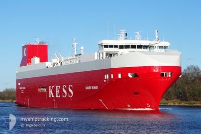
DANUBE HIGHWAY
Vehicles Carrier

Current Trip
| Time Travelled | 18 h, 5 mins |
|---|---|
| Remaining Time | 12 h, 8 mins |
| Distance Travelled | 299.31 nm |
| Remaining Distance | 223.48 nm |
| AVG Speed | 14.7 Noeuds |
| MAX Speed | 18.2 Noeuds |
| AVG Wind | 11.9 knots |
| MAX Wind | 17 knots |
| MIN Temp | 11°C / 51.8°F |
| MAX Temp | 12.8°C / 55.04°F |
| Tirant d eau | 7.4 m |
| Position reçue | 1 m depuis |
Current Position
| Longitude | 19.07787° |
|---|---|
| Latitude | 57.23066° |
| Etat | Under way using engine |
| Vitesse | 17.9 Noeuds |
| Parcours | 37° |
| Zone | Baltic Sea |
| Station | T-AIS |
| Position reçue | 1 m depuis |
Information
The current position of DANUBE HIGHWAY is in Baltic Sea with coordinates 57.23066° / 19.07787° as reported on 2025-06-10 15:12 by AIS to our vessel tracker app. The vessel's current speed is 17.9 Noeuds and is heading at the port of PALDISKI. The estimated time of arrival as calculated by MyShipTracking vessel tracking app is 2025-06-11 06:22 LT
The vessel DANUBE HIGHWAY (IMO: 9316309, MMSI: 308803000) is a Vehicles Carrier that was built in 2006 ( 19 Age ). It's sailing under the flag of [BS] Bahamas.
In this page you can find informations about the vessels current position, last detected port calls, and current voyage information. If the vessels is not in coverage by AIS you will find the latest position.
The current position of DANUBE HIGHWAY is detected by our AIS receivers and we are not responsible for the reliability of the data. The last position was recorded while the vessel was in Coverage by the Ais receivers of our vessel tracking app.
The current draught of DANUBE HIGHWAY as reported by AIS is 7.4 meters
Weather
| Temperature | 11°C / 51.8°F |
|---|---|
| Wind Speed | 13 knots |
| Direction | 201° SSW |
| Pressure | 1012.3 hPa |
| Humidity | 93.3 % |
| Cloud Coverage | 100 % |


Featured Company
Last Port Calls
| Port | Arrival | Departure | Time In Port |
|---|---|---|---|
| 2025-06-08 22:52 | 2025-06-09 23:09 | 1 d | |
| 2025-06-06 05:21 | 2025-06-07 07:36 | 1 d | |
| 2025-06-05 10:20 | 2025-06-05 19:41 | 9 h | |
| 2025-06-03 23:42 | 2025-06-04 14:56 | 15 h | |
| 2025-05-31 05:24 | 2025-06-02 17:05 | 2 d | |
| 2025-05-30 04:46 | 2025-05-30 18:02 | 13 h | |
| 2025-05-28 13:55 | 2025-05-28 21:11 | 7 h | |
| 2025-05-28 05:29 | 2025-05-28 10:51 | 5 h | |
| 2025-05-26 06:02 | 2025-05-26 20:48 | 14 h | |
| 2025-05-23 12:47 | 2025-05-24 14:36 | 1 d |
Last Trips
| Origin | Departure | Destination | Arrival | Distance | |
|---|---|---|---|---|---|
| 2025-06-07 07:36 | 2025-06-08 22:52 | 668.05 nm | |||
| 2025-06-05 19:41 | 2025-06-06 05:21 | 107.71 nm | |||
| 2025-06-04 14:56 | 2025-06-05 10:20 | 305.85 nm | |||
| 2025-06-02 17:05 | 2025-06-03 23:42 | 458.29 nm | |||
| 2025-05-30 18:02 | 2025-05-31 05:24 | 163.55 nm | |||
| 2025-05-28 21:11 | 2025-05-30 04:46 | 515.48 nm | |||
| 2025-05-28 10:51 | 2025-05-28 13:55 | 46.20 nm | |||
| 2025-05-26 20:48 | 2025-05-28 05:29 | 520.35 nm | |||
| 2025-05-24 14:36 | 2025-05-26 06:02 | 668.77 nm | |||
| 2025-05-22 21:10 | 2025-05-23 12:47 | 104.54 nm |
Events
| Heure | Evenement | Détails | Position/ Destination | Info |
|---|---|---|---|---|
| 2025-06-10 14:42 | Etat Changé | Under way using engine Default |
57.10761 / 18.90780
PALDISKI
|
Vitesse: 17.9 kn Parcours: 37° |
| 2025-06-10 14:27 | Dans la zone couverte |
57.11326 / 18.91555
Baltic Sea
PALDISKI
|
Vitesse: 18.1 kn Parcours: 36.7° |
|
| 2025-06-10 06:23 | Etat Changé | Default Under way using engine |
55.63273 / 15.42685
PALDISKI
|
Vitesse: 17.7 kn Parcours: 60° |
| 2025-06-10 06:17 | Changement de zone | Swedish part of the Baltic Sea Danish part of the Kattegat |
55.61840 / 15.38316
Baltic Sea
PALDISKI
|
Vitesse: 17.7 kn Parcours: 60° |
| 2025-06-10 06:17 | Hors de la zone couverte |
55.61840 / 15.38316
Baltic Sea
PALDISKI
|
Vitesse: 17.7 kn Parcours: 60° |
|
| 2025-06-10 05:35 | Etat Changé | Under way using engine Default |
55.51518 / 15.06669
PALDISKI
|
Vitesse: 18.1 kn Parcours: 60° |
| 2025-06-10 05:31 | Etat Changé | Default Under way using engine |
55.50377 / 15.03210
PALDISKI
|
Vitesse: 18.2 kn Parcours: 60.8° |
| 2025-06-10 05:13 | Etat Changé | Under way using engine Default |
55.45935 / 14.89357
PALDISKI
|
Vitesse: 18.2 kn Parcours: 61° |
| 2025-06-10 05:07 | Etat Changé | Default Under way using engine |
55.44443 / 14.84717
PALDISKI
|
Vitesse: 18.2 kn Parcours: 59.6° |
| 2025-06-10 05:01 | Etat Changé | Under way using engine Default |
55.43048 / 14.80510
PALDISKI
|
Vitesse: 18.2 kn Parcours: 59° |