
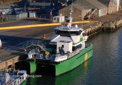
FARRA ORLA
High speed craft
Current Trip
| Trip Time | --- |
|---|---|
| Trip Distance | --- |
| AVG Speed | --- |
| MAX Speed | --- |
| Tirant d eau | --- |
| AVG Wind | --- |
| MAX Wind | --- |
| MIN Temp | --- |
| MAX Temp | --- |
| Position reçue | 20 h, 18 m depuis |
Current Position
| Longitude | 1.72815° |
|---|---|
| Latitude | 52.47578° |
| Etat | Moored |
| Vitesse | 0.4 Noeuds |
| Parcours | 300° |
| Zone | North Sea |
| Station | T-AIS |
| Position reçue | 20 h, 18 m depuis |
Info
Information
The current position of FARRA ORLA is in North Sea with coordinates 52.47578° / 1.72815° as reported on 2025-02-12 16:04 by AIS to our vessel tracker app. The vessel's current speed is 0.4 Noeuds and is currently inside the port of LOWESTOFT.
The vessel FARRA ORLA (IMO: 9925253, MMSI: 232035752) is a High speed craft It's sailing under the flag of [GB] United Kingdom.
In this page you can find informations about the vessels current position, last detected port calls, and current voyage information. If the vessels is not in coverage by AIS you will find the latest position.
The current position of FARRA ORLA is detected by our AIS receivers and we are not responsible for the reliability of the data. The last position was recorded while the vessel was in Coverage by the Ais receivers of our vessel tracking app.
The current draught of FARRA ORLA as reported by AIS is 1.7 meters
Weather
| Temperature | 4.3°C / 39.74°F |
|---|---|
| Wind Speed | 11 knots |
| Direction | 13° NNE |
| Pressure | 1018.8 hPa |
| Humidity | 81.8 % |
| Cloud Coverage | 79 % |
Featured Company
Last Port Calls
| Port | Arrival | Departure | Time In Port |
|---|---|---|---|
| 2025-01-16 14:07 | 2025-02-06 11:17 | 20 d | |
| 2024-12-12 11:14 | 2025-01-16 13:05 | ||
| 2024-12-11 16:57 | 2024-12-12 07:22 | 14 h | |
| 2024-12-04 17:22 | 2024-12-11 09:02 | 6 d | |
| 2024-12-02 14:14 | 2024-12-04 07:07 | 1 d | |
| 2024-12-02 07:06 |
Most Visited Ports (Last year)
| Port | Arrivals | |
|---|---|---|
| 149 | ||
| 4 |
Last Trips
| Origin | Departure | Destination | Arrival | Distance | |
|---|---|---|---|---|---|
| 2025-01-16 13:05 | 2025-01-16 14:07 | 8.68 nm | |||
| 2024-12-12 07:22 | 2024-12-12 11:14 | 33.61 nm | |||
| 2024-12-11 09:02 | 2024-12-11 16:57 | 85.06 nm | |||
| 2024-12-04 07:07 | 2024-12-04 17:22 | 68.55 nm | |||
| 2024-12-02 07:06 | 2024-12-02 14:14 | 39.17 nm |
Events
| Heure | Evenement | Détails | Position/ Destination | Info |
|---|---|---|---|---|
| 2025-02-12 16:04 | Hors de la zone couverte |
52.47578 / 1.72815
North Sea
[GB] LOWESTOFT
|
Vitesse: 0.4 kn Parcours: 356° |
|
| 2025-02-12 16:04 | Dans la zone couverte |
52.47578 / 1.72815
North Sea
[GB] LOWESTOFT
|
Vitesse: 0.4 kn Parcours: 356° |
|
| 2025-02-09 13:10 | Hors de la zone couverte |
52.47594 / 1.72829
North Sea
[GB] LOWESTOFT
|
Vitesse: Parcours: 291° |
|
| 2025-02-09 13:10 | Dans la zone couverte |
52.47594 / 1.72829
North Sea
[GB] LOWESTOFT
|
Vitesse: Parcours: 291° |
|
| 2025-02-07 10:52 | Hors de la zone couverte |
52.47291 / 1.74221
North Sea
[GB] LOWESTOFT
|
Vitesse: 4.5 kn Parcours: 282° |
|
| 2025-02-07 10:48 | Dans la zone couverte |
52.47275 / 1.75200
North Sea
[GB] LOWESTOFT
|
Vitesse: 3.3 kn Parcours: 270° |
|
| 2025-02-06 11:54 | Hors de la zone couverte |
52.47212 / 1.76088
North Sea
|
Vitesse: 10.7 kn Parcours: 248.4° |
|
| 2025-02-06 11:17 | PORT DE DEPART |
|
52.57239 / 1.73994
LOWESTOFT<>EA1 OSWF
|
Vitesse: 6.8 kn Parcours: 102° |
| 2025-02-06 10:54 | Démarrage |
52.60204 / 1.72571
[GB] GREAT YARMOUTH
|
Vitesse: 4.1 kn Parcours: 170° |